La Grange elevation
La Grange (Kentucky, Oldham County), United States elevation is 265 meters and La Grange elevation in feet is 869 ft above sea level [src 1]. La Grange is a seat of a second-order administrative division (feature code) with elevation that is 14 meters (46 ft) smaller than average city elevation in United States.
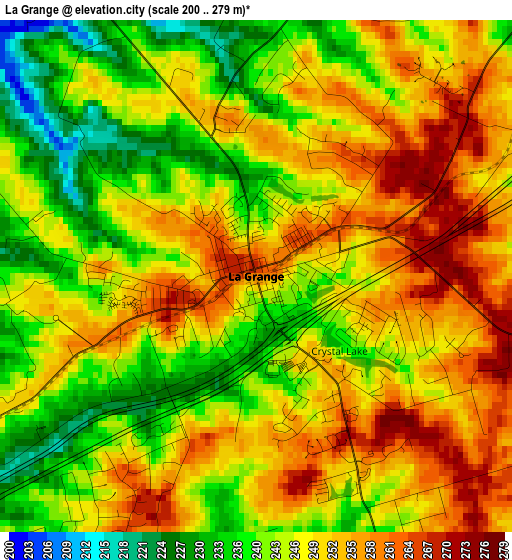
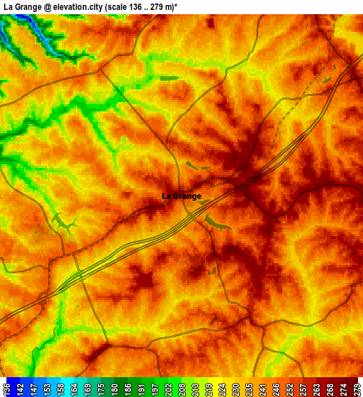
Below is the Elevation map of La Grange, which displays elevation range with different colors. Scale of the first map is from 200 to 279 m (656 to 915 ft) with average elevation of 247 meters (=810 ft) [note 1]
These maps also provides idea of topography and contour of this city, they are displayed at different zoom levels. More info about maps, scale and edge coordinates you can find below images.
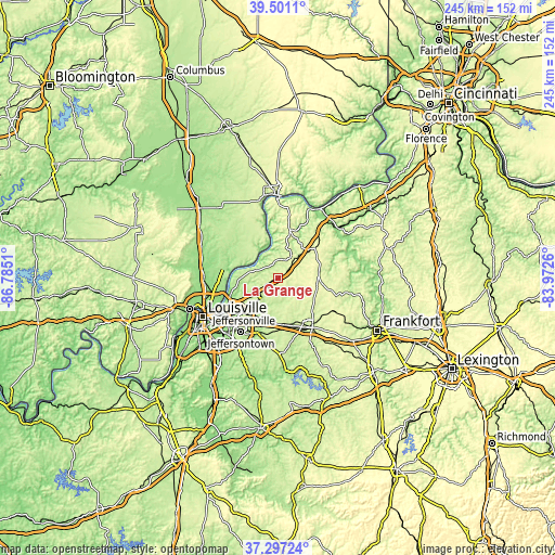
| \ | Map #1 | Map #2 | Topo.Map |
| Scale [m] | 200..279 m | 136..279 m | × |
| Scale [ft] | 656..915 ft | 446..915 ft | × |
| Average | 247 m = 810 ft | 238.8 m = 783 ft | × |
| Width | 7.66 km = 4.8 mi | 15.32 km = 9.5 mi | 245 km = 152.2 mi |
| Height | 7.66 km = 4.8 mi | 15.32 km = 9.5 mi | 245 km = 152.2 mi |
| ↑Max Latitude | 38.441998° | 38.476409° | 39.5011° |
| Latitude at center | 38.40757° | 38.40757° | 38.40757° |
| ↓Min Latitude | 38.373126° | 38.338665° | 37.29724° |
| ← Min Longitude | -85.422795° | -85.466741° | -86.7851° |
| Longitude center | -85.37885° | -85.37885° | -85.37885° |
| →Max Longitude | -85.334905° | -85.290959° | -83.9726° |
Nearby cities:
Cities around La Grange sort by population:
• Buckner elevation 251 m
6 km,  243°
243°
• Crestwood 240 m
12.3 km,  221°
221°
• Simpsonville 245 m
20.7 km,  174°
174°
• Eminence 284 m
17.8 km,  103°
103°
• Anchorage 222 m
20.6 km, 220°
• Orchard Grass Hills 202 m
15.5 km,  233°
233°
• Worthington 213 m
18.9 km, 237°
• Pewee Valley 239 m
14.3 km, 221°
• Worthington Hills 225 m
16.9 km, 229°
• Coldstream 232 m
16.3 km, 230°
• New Castle 256 m
18.4 km,  81°
81°
• Bedford 276 m
21.2 km,  14°
14°
Multilingual:
 En español:
La Grange elevación 265 m.
 En France:
La Grange élévation 265 m.
 Auf Deutsch:
La Grange höhe über dem Meeresspiegel ist 265 m.

Sources and notes:
- [note 1] Map square and city borders are not equal. Map elevation data is calculated only from area inside that square.
- [src 1] Elevation data from geonames database provided with same terms of usage.
- [src 2] The elevation map of La Grange is generated using elevation data from NASA's 3 arcsec (90m) resolution SRTM data.
- [src 3] Base (background) map © OpenStreetMap contributors tiles are generated by Geofabrik and OpenTopoMap.
Copyright & License:
This La Grange Elevation Map is licensed under CC BY-SA. You may reuse any part from this page, if you give a proper credit by linking to this URL:
 More info on terms of use page.