Buckner elevation
Buckner (Kentucky, Oldham County), United States elevation is 251 meters and Buckner elevation in feet is 823 ft above sea level [src 1]. Buckner is a populated place (feature code) with elevation that is 28 meters (92 ft) smaller than average city elevation in United States.
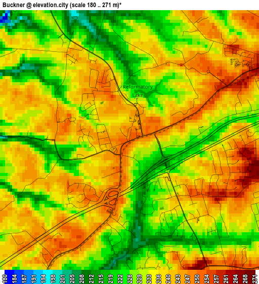
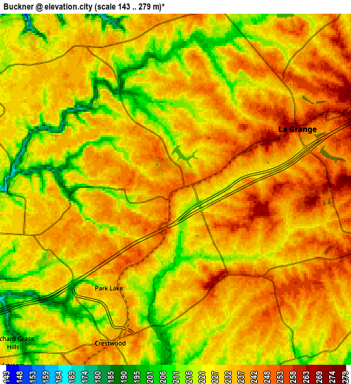
Below is the Elevation map of Buckner, which displays elevation range with different colors. Scale of the first map is from 180 to 271 m (591 to 889 ft) with average elevation of 233.9 meters (=767 ft) [note 1]
These maps also provides idea of topography and contour of this city, they are displayed at different zoom levels. More info about maps, scale and edge coordinates you can find below images.
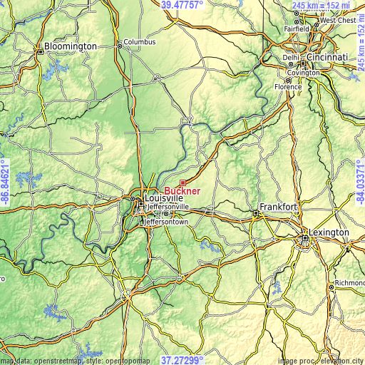
| \ | Map #1 | Map #2 | Topo.Map |
| Scale [m] | 180..271 m | 143..279 m | × |
| Scale [ft] | 591..889 ft | 469..915 ft | × |
| Average | 233.9 m = 767 ft | 230.8 m = 757 ft | × |
| Width | 7.66 km = 4.8 mi | 15.32 km = 9.5 mi | 245.1 km = 152.3 mi |
| Height | 7.66 km = 4.8 mi | 15.32 km = 9.5 mi | 245.1 km = 152.3 mi |
| ↑Max Latitude | 38.418119° | 38.452542° | 39.47757° |
| Latitude at center | 38.38368° | 38.38368° | 38.38368° |
| ↓Min Latitude | 38.349224° | 38.314752° | 37.27299° |
| ← Min Longitude | -85.483905° | -85.527851° | -86.84621° |
| Longitude center | -85.43996° | -85.43996° | -85.43996° |
| →Max Longitude | -85.396015° | -85.352069° | -84.03371° |
Nearby cities:
Cities around Buckner sort by population:
• La Grange elevation 265 m
6 km,  63°
63°
• Middletown 221 m
17.6 km,  209°
209°
• Douglass Hills 219 m
19 km, 211°
• Prospect 147 m
15.9 km,  254°
254°
• Crestwood 240 m
7.2 km,  203°
203°
• Anchorage 222 m
15.3 km, 211°
• Orchard Grass Hills 202 m
9.7 km,  226°
226°
• Worthington 213 m
13 km, 234°
• Pewee Valley 239 m
9.1 km, 207°
• Worthington Hills 225 m
11.2 km,  222°
222°
• Barbourmeade 195 m
17.2 km,  236°
236°
• Coldstream 232 m
10.6 km, 223°
Multilingual:
 En español:
Buckner elevación 251 m.
 En France:
Buckner élévation 251 m.


Sources and notes:
- [note 1] Map square and city borders are not equal. Map elevation data is calculated only from area inside that square.
- [src 1] Elevation data from geonames database provided with same terms of usage.
- [src 2] The elevation map of Buckner is generated using elevation data from NASA's 3 arcsec (90m) resolution SRTM data.
- [src 3] Base (background) map © OpenStreetMap contributors tiles are generated by Geofabrik and OpenTopoMap.
Copyright & License:
This Buckner Elevation Map is licensed under CC BY-SA. You may reuse any part from this page, if you give a proper credit by linking to this URL:
 More info on terms of use page.