Hurstbourne elevation
Hurstbourne (Kentucky, Jefferson County), United States elevation is 194 meters and Hurstbourne elevation in feet is 636 ft above sea level [src 1]. Hurstbourne is a populated place (feature code) with elevation that is 85 meters (279 ft) smaller than average city elevation in United States.
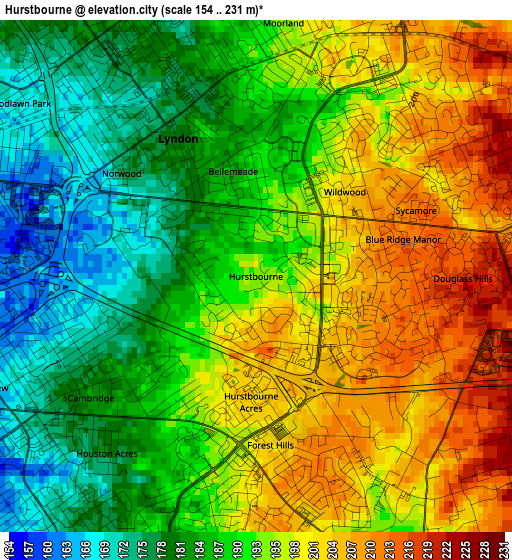
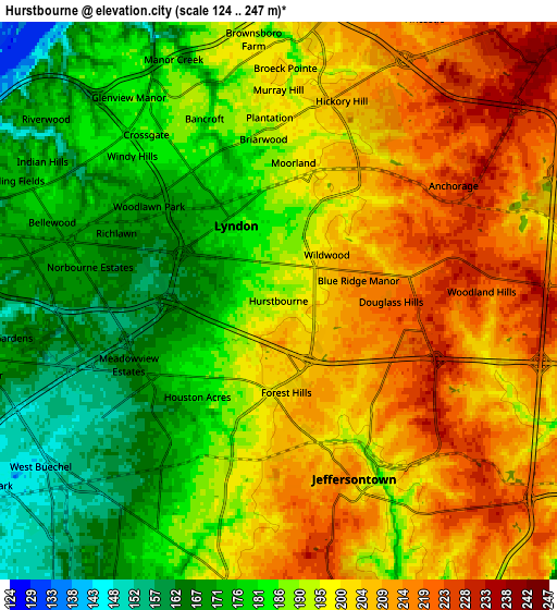
Below is the Elevation map of Hurstbourne, which displays elevation range with different colors. Scale of the first map is from 154 to 231 m (505 to 758 ft) with average elevation of 191.8 meters (=629 ft) [note 1]
These maps also provides idea of topography and contour of this city, they are displayed at different zoom levels. More info about maps, scale and edge coordinates you can find below images.
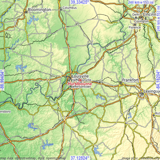
| \ | Map #1 | Map #2 | Topo.Map |
| Scale [m] | 154..231 m | 124..247 m | × |
| Scale [ft] | 505..758 ft | 407..810 ft | × |
| Average | 191.8 m = 629 ft | 192.8 m = 633 ft | × |
| Width | 7.68 km = 4.8 mi | 15.35 km = 9.5 mi | 245.6 km = 152.6 mi |
| Height | 7.68 km = 4.8 mi | 15.35 km = 9.5 mi | 245.6 km = 152.6 mi |
| ↑Max Latitude | 38.272638° | 38.30713° | 39.33425° |
| Latitude at center | 38.23813° | 38.23813° | 38.23813° |
| ↓Min Latitude | 38.203605° | 38.169064° | 37.12524° |
| ← Min Longitude | -85.632235° | -85.676181° | -86.99454° |
| Longitude center | -85.58829° | -85.58829° | -85.58829° |
| →Max Longitude | -85.544345° | -85.500399° | -84.18204° |
Nearby cities:
Cities around Hurstbourne sort by population:
• Jeffersontown elevation 215 m
5.3 km,  156°
156°
• Saint Matthews 168 m
6.1 km,  285°
285°
• Lyndon 180 m
2.4 km,  330°
330°
• Middletown 221 m
4.4 km,  79°
79°
• Douglass Hills 219 m
3.1 km,  90°
90°
• Graymoor-Devondale 185 m
4.9 km,  322°
322°
• Windy Hills 181 m
5.7 km,  314°
314°
• Anchorage 222 m
5.8 km,  56°
56°
• Hurstbourne Acres 200 m
1.9 km,  182°
182°
• Saint Regis Park 176 m
2.8 km,  242°
242°
• Beechwood Village 167 m
4.2 km,  296°
296°
• Barbourmeade 195 m
6.7 km,  348°
348°
Multilingual:
 En español:
Hurstbourne elevación 194 m.
 En France:
Hurstbourne élévation 194 m.
 Auf Deutsch:
Hurstbourne höhe über dem Meeresspiegel ist 194 m.

Sources and notes:
- [note 1] Map square and city borders are not equal. Map elevation data is calculated only from area inside that square.
- [src 1] Elevation data from geonames database provided with same terms of usage.
- [src 2] The elevation map of Hurstbourne is generated using elevation data from NASA's 3 arcsec (90m) resolution SRTM data.
- [src 3] Base (background) map © OpenStreetMap contributors tiles are generated by Geofabrik and OpenTopoMap.
Copyright & License:
This Hurstbourne Elevation Map is licensed under CC BY-SA. You may reuse any part from this page, if you give a proper credit by linking to this URL:
 More info on terms of use page.