Carrollton elevation
Carrollton (Kentucky, Carroll County), United States elevation is 149 meters and Carrollton elevation in feet is 489 ft above sea level [src 1]. Carrollton is a seat of a second-order administrative division (feature code) with elevation that is 130 meters (427 ft) smaller than average city elevation in United States.
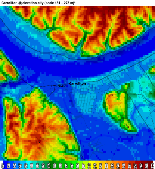
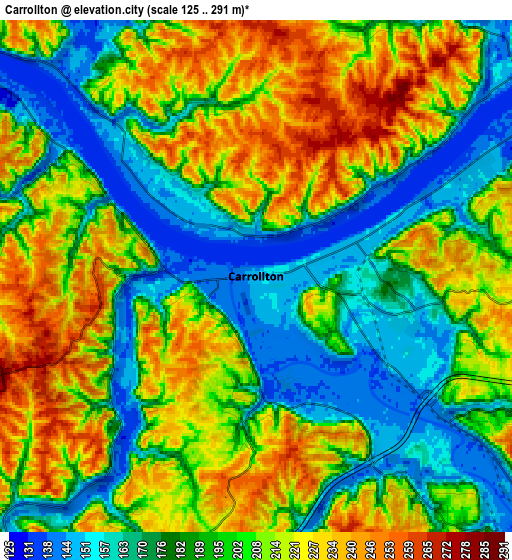
Below is the Elevation map of Carrollton, which displays elevation range with different colors. Scale of the first map is from 131 to 273 m (430 to 896 ft) with average elevation of 178.1 meters (=584 ft) [note 1]
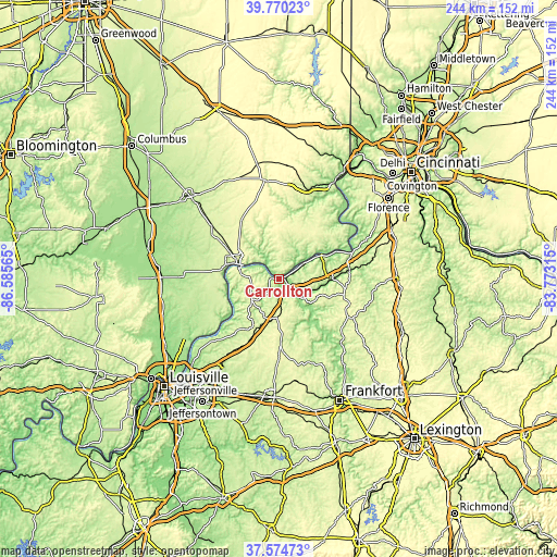
These maps also provides idea of topography and contour of this city, they are displayed at different zoom levels. More info about maps, scale and edge coordinates you can find below images.
| \ | Map #1 | Map #2 | Topo.Map |
| Scale [m] | 131..273 m | 125..291 m | × |
| Scale [ft] | 430..896 ft | 410..955 ft | × |
| Average | 178.1 m = 584 ft | 198.2 m = 650 ft | × |
| Width | 7.63 km = 4.7 mi | 15.26 km = 9.5 mi | 244.1 km = 151.7 mi |
| Height | 7.63 km = 4.7 mi | 15.26 km = 9.5 mi | 244.1 km = 151.7 mi |
| ↑Max Latitude | 38.715197° | 38.749478° | 39.77023° |
| Latitude at center | 38.6809° | 38.6809° | 38.6809° |
| ↓Min Latitude | 38.646586° | 38.612256° | 37.57473° |
| ← Min Longitude | -85.223345° | -85.267291° | -86.58565° |
| Longitude center | -85.1794° | -85.1794° | -85.1794° |
| →Max Longitude | -85.135455° | -85.091509° | -83.77315° |
Nearby cities:
Cities around Carrollton sort by population:
• North Madison elevation 275 m
21.2 km,  297°
297°
• Madison 150 m
18.4 km,  289°
289°
• La Grange 265 m
35 km,  209°
209°
• Hanover 238 m
25.8 km,  278°
278°
• Providence 255 m
12.4 km,  197°
197°
• Eminence 284 m
34.6 km,  180°
180°
• Warsaw 150 m
26.7 km,  64°
64°
• Vevay 149 m
12.3 km,  52°
52°
• Owenton 296 m
33.3 km,  118°
118°
• Dillsboro 266 m
38.9 km,  15°
15°
• New Castle 256 m
27.5 km, 178°
• Bedford 276 m
15.5 km,  230°
230°
Multilingual:
 En español:
Carrollton elevación 149 m.
 En France:
Carrollton élévation 149 m.
 Auf Deutsch:
Carrollton höhe über dem Meeresspiegel ist 149 m.

Sources and notes:
- [note 1] Map square and city borders are not equal. Map elevation data is calculated only from area inside that square.
- [src 1] Elevation data from geonames database provided with same terms of usage.
- [src 2] The elevation map of Carrollton is generated using elevation data from NASA's 3 arcsec (90m) resolution SRTM data.
- [src 3] Base (background) map © OpenStreetMap contributors tiles are generated by Geofabrik and OpenTopoMap.
Copyright & License:
This Carrollton Elevation Map is licensed under CC BY-SA. You may reuse any part from this page, if you give a proper credit by linking to this URL:
 More info on terms of use page.