Wamego elevation
Wamego (Kansas, Pottawatomie County), United States elevation is 307 meters and Wamego elevation in feet is 1007 ft above sea level [src 1]. Wamego is a populated place (feature code) with elevation that is 28 meters (92 ft) bigger than average city elevation in United States.
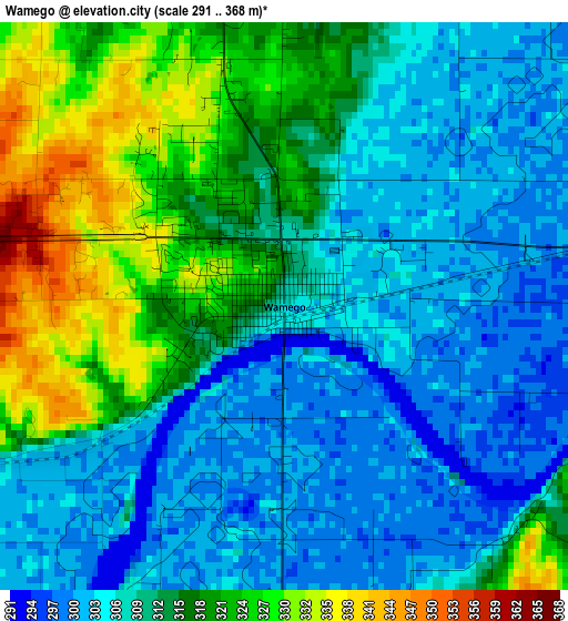
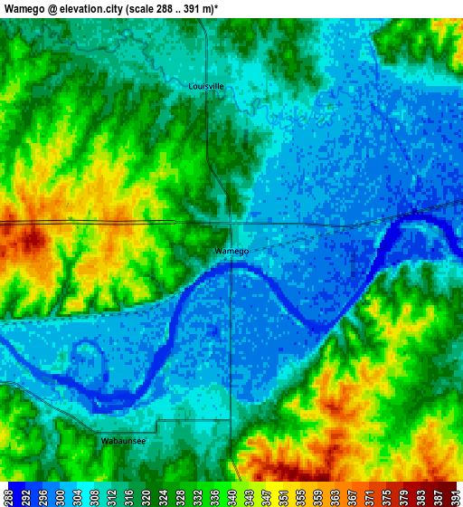
Below is the Elevation map of Wamego, which displays elevation range with different colors. Scale of the first map is from 291 to 368 m (955 to 1207 ft) with average elevation of 311.7 meters (=1023 ft) [note 1]
These maps also provides idea of topography and contour of this city, they are displayed at different zoom levels. More info about maps, scale and edge coordinates you can find below images.
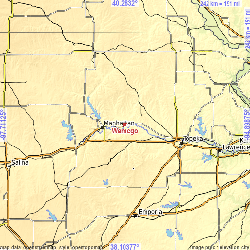
| \ | Map #1 | Map #2 | Topo.Map |
| Scale [m] | 291..368 m | 288..391 m | × |
| Scale [ft] | 955..1207 ft | 945..1283 ft | × |
| Average | 311.7 m = 1023 ft | 319.5 m = 1048 ft | × |
| Width | 7.57 km = 4.7 mi | 15.15 km = 9.4 mi | 242.3 km = 150.6 mi |
| Height | 7.57 km = 4.7 mi | 15.15 km = 9.4 mi | 242.3 km = 150.6 mi |
| ↑Max Latitude | 39.235986° | 39.270015° | 40.2832° |
| Latitude at center | 39.20194° | 39.20194° | 39.20194° |
| ↓Min Latitude | 39.167878° | 39.133799° | 38.10377° |
| ← Min Longitude | -96.348945° | -96.392891° | -97.71125° |
| Longitude center | -96.305° | -96.305° | -96.305° |
| →Max Longitude | -96.261055° | -96.217109° | -94.89875° |
Nearby cities:
Cities around Wamego sort by population:
• Topeka elevation 306 m
56.7 km,  107°
107°
• Manhattan 315 m
23.1 km,  264°
264°
• Junction City 342 m
49.3 km,  247°
247°
• Fort Riley North 408 m
45 km, 256°
• Saint Marys 297 m
20.2 km,  92°
92°
• Ogden 321 m
36 km, 253°
• Grandview Plaza 346 m
46 km, 245°
• Silver Lake 284 m
40 km, 105°
• Auburn 335 m
53.5 km,  127°
127°
• Rossville 287 m
31.3 km,  103°
103°
• Alma 340 m
20.6 km,  176°
176°
• Westmoreland 370 m
23.3 km,  336°
336°
Multilingual:
 En español:
Wamego elevación 307 m.
 En France:
Wamego élévation 307 m.


Sources and notes:
- [note 1] Map square and city borders are not equal. Map elevation data is calculated only from area inside that square.
- [src 1] Elevation data from geonames database provided with same terms of usage.
- [src 2] The elevation map of Wamego is generated using elevation data from NASA's 3 arcsec (90m) resolution SRTM data.
- [src 3] Base (background) map © OpenStreetMap contributors tiles are generated by Geofabrik and OpenTopoMap.
Copyright & License:
This Wamego Elevation Map is licensed under CC BY-SA. You may reuse any part from this page, if you give a proper credit by linking to this URL:
 More info on terms of use page.