Ottawa elevation
Ottawa (Kansas, Franklin County), United States elevation is 277 meters and Ottawa elevation in feet is 909 ft above sea level [src 1]. Ottawa is a seat of a second-order administrative division (feature code) with elevation that is 2 meters (7 ft) smaller than average city elevation in United States.
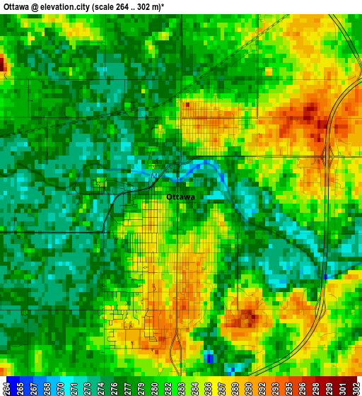
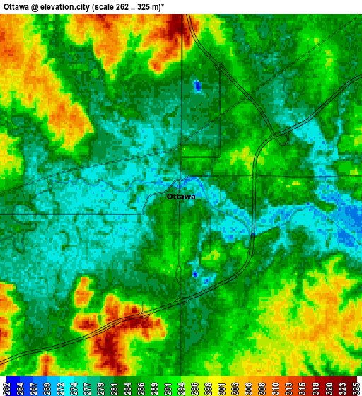
Below is the Elevation map of Ottawa, which displays elevation range with different colors. Scale of the first map is from 264 to 302 m (866 to 991 ft) with average elevation of 280.8 meters (=921 ft) [note 1]
These maps also provides idea of topography and contour of this city, they are displayed at different zoom levels. More info about maps, scale and edge coordinates you can find below images.
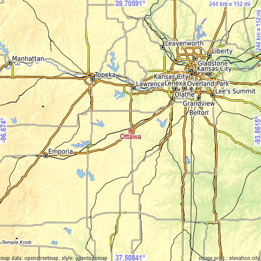
| \ | Map #1 | Map #2 | Topo.Map |
| Scale [m] | 264..302 m | 262..325 m | × |
| Scale [ft] | 866..991 ft | 860..1066 ft | × |
| Average | 280.8 m = 921 ft | 286.8 m = 941 ft | × |
| Width | 7.64 km = 4.7 mi | 15.27 km = 9.5 mi | 244.3 km = 151.8 mi |
| Height | 7.64 km = 4.7 mi | 15.27 km = 9.5 mi | 244.3 km = 151.8 mi |
| ↑Max Latitude | 38.649898° | 38.684211° | 39.70591° |
| Latitude at center | 38.61557° | 38.61557° | 38.61557° |
| ↓Min Latitude | 38.581225° | 38.546864° | 37.50841° |
| ← Min Longitude | -95.311695° | -95.355641° | -96.674° |
| Longitude center | -95.26775° | -95.26775° | -95.26775° |
| →Max Longitude | -95.223805° | -95.179859° | -93.8615° |
Nearby cities:
Cities around Ottawa sort by population:
• Lawrence elevation 267 m
39.7 km,  4°
4°
• Gardner 327 m
36.7 km,  53°
53°
• Eudora 260 m
39.3 km,  21°
21°
• Paola 284 m
34.1 km,  98°
98°
• Baldwin City 320 m
19.1 km, 21°
• Osawatomie 268 m
30.6 km,  115°
115°
• Garnett 330 m
37.3 km,  176°
176°
• Wellsville 320 m
19.8 km, 54°
• Edgerton 311 m
28 km, 53°
• New Century, KS 319 m
39.4 km, 54°
• Overbrook 372 m
31.1 km,  306°
306°
• Lyndon 320 m
36.2 km,  269°
269°
Multilingual:
 En español:
Ottawa elevación 277 m.
 En France:
Ottawa élévation 277 m.


Sources and notes:
- [note 1] Map square and city borders are not equal. Map elevation data is calculated only from area inside that square.
- [src 1] Elevation data from geonames database provided with same terms of usage.
- [src 2] The elevation map of Ottawa is generated using elevation data from NASA's 3 arcsec (90m) resolution SRTM data.
- [src 3] Base (background) map © OpenStreetMap contributors tiles are generated by Geofabrik and OpenTopoMap.
Copyright & License:
This Ottawa Elevation Map is licensed under CC BY-SA. You may reuse any part from this page, if you give a proper credit by linking to this URL:
 More info on terms of use page.