Eudora elevation
Eudora (Kansas, Douglas County), United States elevation is 260 meters and Eudora elevation in feet is 853 ft above sea level [src 1]. Eudora is a populated place (feature code) with elevation that is 19 meters (62 ft) smaller than average city elevation in United States.
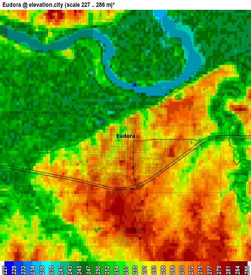
Below is the Elevation map of Eudora, which displays elevation range with different colors. Scale of the first map is from 227 to 286 m (745 to 938 ft) with average elevation of 258 meters (=846 ft) [note 1]
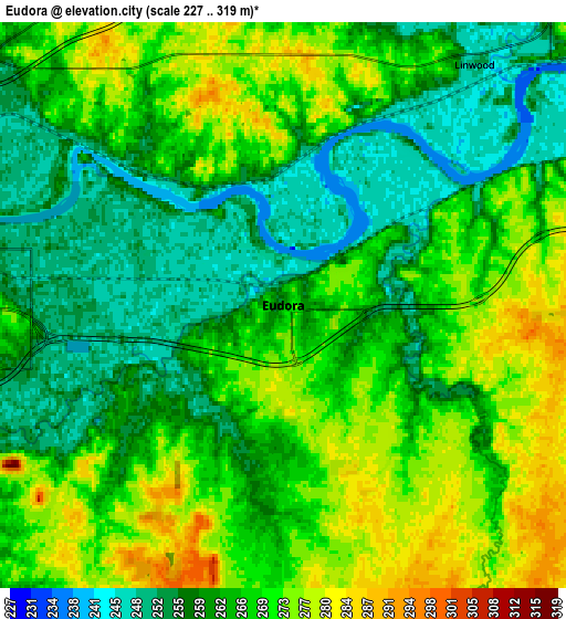
These maps also provides idea of topography and contour of this city, they are displayed at different zoom levels. More info about maps, scale and edge coordinates you can find below images.
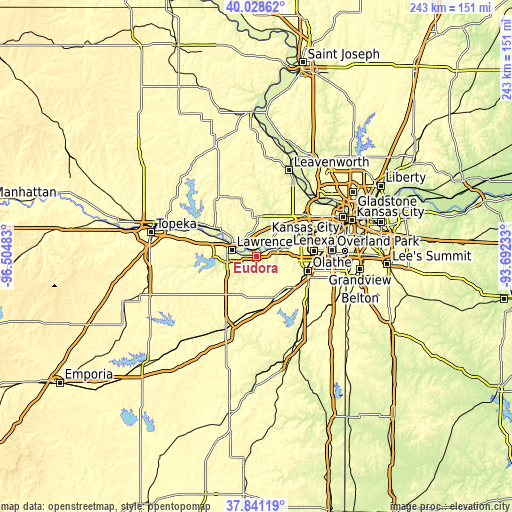
| \ | Map #1 | Map #2 | Topo.Map |
| Scale [m] | 227..286 m | 227..319 m | × |
| Scale [ft] | 745..938 ft | 745..1047 ft | × |
| Average | 258 m = 846 ft | 265.1 m = 870 ft | × |
| Width | 7.6 km = 4.7 mi | 15.2 km = 9.4 mi | 243.2 km = 151.1 mi |
| Height | 7.6 km = 4.7 mi | 15.2 km = 9.4 mi | 243.2 km = 151.1 mi |
| ↑Max Latitude | 38.977511° | 39.011666° | 40.02862° |
| Latitude at center | 38.94334° | 38.94334° | 38.94334° |
| ↓Min Latitude | 38.909153° | 38.874949° | 37.84119° |
| ← Min Longitude | -95.142525° | -95.186471° | -96.50483° |
| Longitude center | -95.09858° | -95.09858° | -95.09858° |
| →Max Longitude | -95.054635° | -95.010689° | -93.69233° |
Nearby cities:
Cities around Eudora sort by population:
• Olathe elevation 324 m
25.1 km,  105°
105°
• Lawrence 267 m
12.2 km,  284°
284°
• Gardner 327 m
20.9 km,  134°
134°
• Bonner Springs 271 m
22.6 km,  55°
55°
• De Soto 267 m
11.9 km,  70°
70°
• Basehor 304 m
26 km,  32°
32°
• Tonganoxie 275 m
18.5 km,  2°
2°
• Baldwin City 320 m
20.2 km,  202°
202°
• Edwardsville 242 m
27.4 km, 61°
• Wellsville 320 m
25.1 km,  176°
176°
• Edgerton 311 m
21.4 km,  158°
158°
• New Century, KS 319 m
21.8 km, 127°
Multilingual:
 En español:
Eudora elevación 260 m.
 En France:
Eudora élévation 260 m.


Sources and notes:
- [note 1] Map square and city borders are not equal. Map elevation data is calculated only from area inside that square.
- [src 1] Elevation data from geonames database provided with same terms of usage.
- [src 2] The elevation map of Eudora is generated using elevation data from NASA's 3 arcsec (90m) resolution SRTM data.
- [src 3] Base (background) map © OpenStreetMap contributors tiles are generated by Geofabrik and OpenTopoMap.
Copyright & License:
This Eudora Elevation Map is licensed under CC BY-SA. You may reuse any part from this page, if you give a proper credit by linking to this URL:
 More info on terms of use page.