Zionsville elevation
Zionsville (Indiana, Boone County), United States elevation is 259 meters and Zionsville elevation in feet is 850 ft above sea level [src 1]. Zionsville is a populated place (feature code) with elevation that is 20 meters (66 ft) smaller than average city elevation in United States.
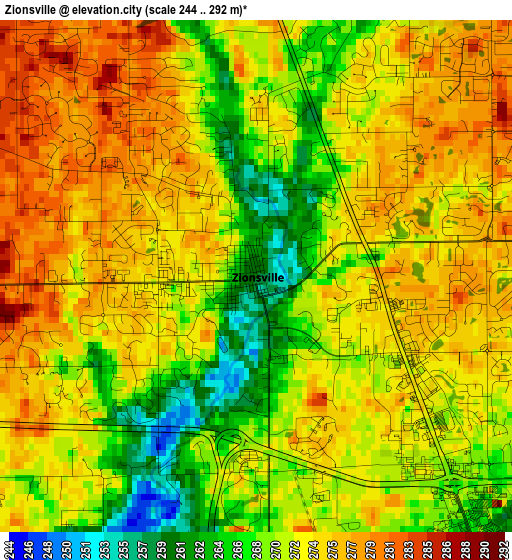
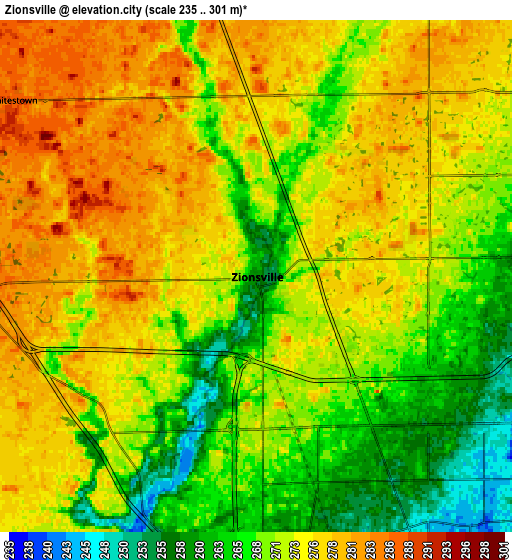
Below is the Elevation map of Zionsville, which displays elevation range with different colors. Scale of the first map is from 244 to 292 m (801 to 958 ft) with average elevation of 272 meters (=892 ft) [note 1]
These maps also provides idea of topography and contour of this city, they are displayed at different zoom levels. More info about maps, scale and edge coordinates you can find below images.
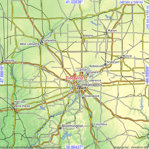
| \ | Map #1 | Map #2 | Topo.Map |
| Scale [m] | 244..292 m | 235..301 m | × |
| Scale [ft] | 801..958 ft | 771..988 ft | × |
| Average | 272 m = 892 ft | 272 m = 892 ft | × |
| Width | 7.49 km = 4.7 mi | 14.98 km = 9.3 mi | 239.7 km = 148.9 mi |
| Height | 7.49 km = 4.7 mi | 14.98 km = 9.3 mi | 239.7 km = 148.9 mi |
| ↑Max Latitude | 39.98455° | 40.018213° | 41.02038° |
| Latitude at center | 39.95087° | 39.95087° | 39.95087° |
| ↓Min Latitude | 39.917173° | 39.88346° | 38.86437° |
| ← Min Longitude | -86.305885° | -86.349831° | -87.66819° |
| Longitude center | -86.26194° | -86.26194° | -86.26194° |
| →Max Longitude | -86.217995° | -86.174049° | -84.85569° |
Nearby cities:
Cities around Zionsville sort by population:
• Carmel elevation 262 m
12.6 km,  75°
75°
• Westfield 270 m
15.4 km,  48°
48°
• Brownsburg 268 m
16.6 km,  224°
224°
• Fairfield Heights 270 m
17 km, 217°
• Broad Ripple 222 m
13.9 km,  132°
132°
• Lebanon 291 m
20.7 km,  301°
301°
• Speedway 231 m
16.5 km,  181°
181°
• Whitestown 287 m
8.8 km,  305°
305°
• Pittsboro 289 m
20 km,  241°
241°
• Meridian Hills 246 m
11.2 km, 127°
• Dale 295 m
13.9 km, 301°
• Clermont 258 m
16.5 km,  198°
198°
Multilingual:
 En español:
Zionsville elevación 259 m.
 En France:
Zionsville élévation 259 m.
 Auf Deutsch:
Zionsville höhe über dem Meeresspiegel ist 259 m.

Sources and notes:
- [note 1] Map square and city borders are not equal. Map elevation data is calculated only from area inside that square.
- [src 1] Elevation data from geonames database provided with same terms of usage.
- [src 2] The elevation map of Zionsville is generated using elevation data from NASA's 3 arcsec (90m) resolution SRTM data.
- [src 3] Base (background) map © OpenStreetMap contributors tiles are generated by Geofabrik and OpenTopoMap.
Copyright & License:
This Zionsville Elevation Map is licensed under CC BY-SA. You may reuse any part from this page, if you give a proper credit by linking to this URL:
 More info on terms of use page.