Pittsboro elevation
Pittsboro (Indiana, Hendricks County), United States elevation is 289 meters and Pittsboro elevation in feet is 948 ft above sea level [src 1]. Pittsboro is a populated place (feature code) with elevation that is 10 meters (33 ft) bigger than average city elevation in United States.
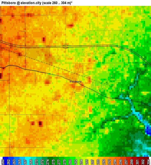
Below is the Elevation map of Pittsboro, which displays elevation range with different colors. Scale of the first map is from 260 to 304 m (853 to 997 ft) with average elevation of 285.2 meters (=936 ft) [note 1]
These maps also provides idea of topography and contour of this city, they are displayed at different zoom levels. More info about maps, scale and edge coordinates you can find below images.
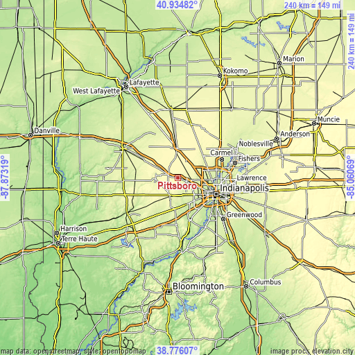
| \ | Map #1 | Topo.Map |
| Scale [m] | 260..304 m | × |
| Scale [ft] | 853..997 ft | × |
| Average | 285.2 m = 936 ft | × |
| Width | 7.5 km = 4.7 mi | 240 km = 149.1 mi |
| Height | 7.5 km = 4.7 mi | 240 km = 149.1 mi |
| ↑Max Latitude | 39.897653° | 40.93482° |
| Latitude at center | 39.86393° | 39.86393° |
| ↓Min Latitude | 39.830191° | 38.77607° |
| ← Min Longitude | -86.510885° | -87.87319° |
| Longitude center | -86.46694° | -86.46694° |
| →Max Longitude | -86.422995° | -85.06069° |
Nearby cities:
Cities around Pittsboro sort by population:
• Plainfield elevation 224 m
18.7 km,  162°
162°
• Zionsville 259 m
20 km,  61°
61°
• Brownsburg 268 m
6.3 km,  111°
111°
• Fairfield Heights 270 m
8.2 km,  118°
118°
• Avon 254 m
12.6 km,  152°
152°
• Lebanon 291 m
20.5 km,  359°
359°
• Speedway 231 m
18.4 km, 111°
• Danville 295 m
12.6 km,  203°
203°
• Whitestown 287 m
18.1 km,  34°
34°
• Heritage Lake 261 m
25.7 km,  233°
233°
• Dale 295 m
17.9 km,  18°
18°
• Clermont 258 m
13.7 km, 116°
Multilingual:
 En español:
Pittsboro elevación 289 m.
 En France:
Pittsboro élévation 289 m.
 Auf Deutsch:
Pittsboro höhe über dem Meeresspiegel ist 289 m.

Sources and notes:
- [note 1] Map square and city borders are not equal. Map elevation data is calculated only from area inside that square.
- [src 1] Elevation data from geonames database provided with same terms of usage.
- [src 2] The elevation map of Pittsboro is generated using elevation data from NASA's 3 arcsec (90m) resolution SRTM data.
- [src 3] Base (background) map © OpenStreetMap contributors tiles are generated by Geofabrik and OpenTopoMap.
Copyright & License:
This Pittsboro Elevation Map is licensed under CC BY-SA. You may reuse any part from this page, if you give a proper credit by linking to this URL:
 More info on terms of use page.