Louisville elevation
Louisville (Illinois, Clay County), United States elevation is 147 meters and Louisville elevation in feet is 482 ft above sea level [src 1]. Louisville is a seat of a second-order administrative division (feature code) with elevation that is 132 meters (433 ft) smaller than average city elevation in United States.
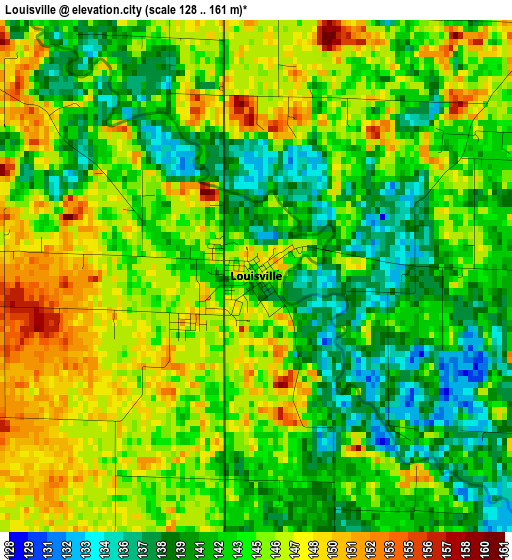
Below is the Elevation map of Louisville, which displays elevation range with different colors. Scale of the first map is from 128 to 161 m (420 to 528 ft) with average elevation of 143.7 meters (=471 ft) [note 1]
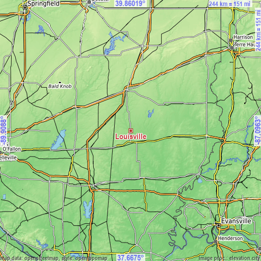
These maps also provides idea of topography and contour of this city, they are displayed at different zoom levels. More info about maps, scale and edge coordinates you can find below images.
| \ | Map #1 | Topo.Map |
| Scale [m] | 128..161 m | × |
| Scale [ft] | 420..528 ft | × |
| Average | 143.7 m = 471 ft | × |
| Width | 7.62 km = 4.7 mi | 243.8 km = 151.5 mi |
| Height | 7.62 km = 4.7 mi | 243.8 km = 151.5 mi |
| ↑Max Latitude | 38.806523° | 39.86019° |
| Latitude at center | 38.77227° | 38.77227° |
| ↓Min Latitude | 38.738° | 37.6675° |
| ← Min Longitude | -88.546495° | -89.9088° |
| Longitude center | -88.50255° | -88.50255° |
| →Max Longitude | -88.458605° | -87.0963° |
Nearby cities:
Cities around Louisville sort by population:
• Effingham elevation 181 m
38.8 km,  354°
354°
• Olney 145 m
36.5 km,  97°
97°
• Salem 165 m
41.7 km,  247°
247°
• Vandalia 161 m
55.3 km,  292°
292°
• Fairfield 134 m
45.5 km,  164°
164°
• Flora 154 m
11.6 km,  172°
172°
• Newton 165 m
38.2 km,  50°
50°
• Altamont 190 m
38.6 km,  326°
326°
• Teutopolis 185 m
40.2 km,  3°
3°
• Saint Elmo 187 m
41.2 km,  313°
313°
• Odin 160 m
50.7 km, 250°
• Wayne City 129 m
48 km,  188°
188°
Multilingual:
 En español:
Louisville elevación 147 m.
 En France:
Louisville élévation 147 m.
 Auf Deutsch:
Louisville höhe über dem Meeresspiegel ist 147 m.

Sources and notes:
- [note 1] Map square and city borders are not equal. Map elevation data is calculated only from area inside that square.
- [src 1] Elevation data from geonames database provided with same terms of usage.
- [src 2] The elevation map of Louisville is generated using elevation data from NASA's 3 arcsec (90m) resolution SRTM data.
- [src 3] Base (background) map © OpenStreetMap contributors tiles are generated by Geofabrik and OpenTopoMap.
Copyright & License:
This Louisville Elevation Map is licensed under CC BY-SA. You may reuse any part from this page, if you give a proper credit by linking to this URL:
 More info on terms of use page.