Auburn elevation
Auburn (Illinois, Sangamon County), United States elevation is 191 meters and Auburn elevation in feet is 627 ft above sea level [src 1]. Auburn is a populated place (feature code) with elevation that is 88 meters (289 ft) smaller than average city elevation in United States.
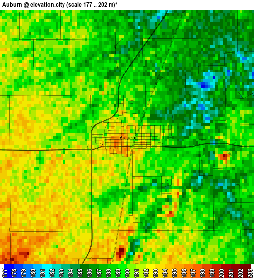
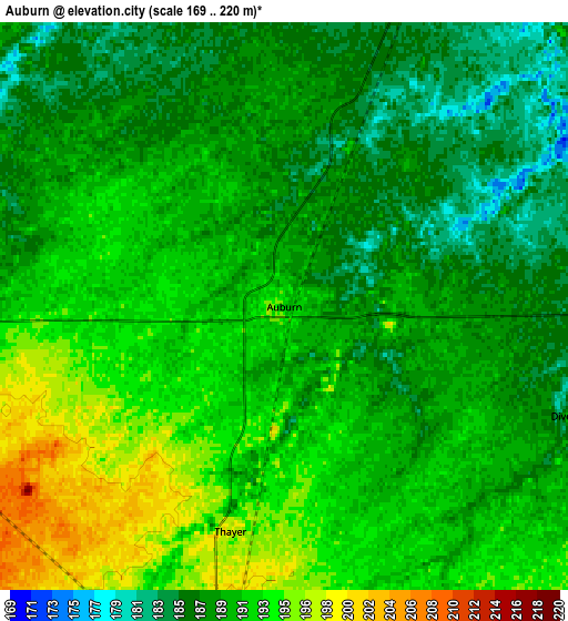
Below is the Elevation map of Auburn, which displays elevation range with different colors. Scale of the first map is from 177 to 202 m (581 to 663 ft) with average elevation of 189.2 meters (=621 ft) [note 1]
These maps also provides idea of topography and contour of this city, they are displayed at different zoom levels. More info about maps, scale and edge coordinates you can find below images.
| \ | Map #1 | Map #2 | Topo.Map |
| Scale [m] | 177..202 m | 169..220 m | × |
| Scale [ft] | 581..663 ft | 554..722 ft | × |
| Average | 189.2 m = 621 ft | 189.6 m = 622 ft | × |
| Width | 7.53 km = 4.7 mi | 15.06 km = 9.4 mi | 241 km = 149.8 mi |
| Height | 7.53 km = 4.7 mi | 15.06 km = 9.4 mi | 241 km = 149.8 mi |
| ↑Max Latitude | 39.625576° | 39.659416° | 40.66689° |
| Latitude at center | 39.59172° | 39.59172° | 39.59172° |
| ↓Min Latitude | 39.557847° | 39.523958° | 38.4996° |
| ← Min Longitude | -89.790435° | -89.834381° | -91.15274° |
| Longitude center | -89.74649° | -89.74649° | -89.74649° |
| →Max Longitude | -89.702545° | -89.658599° | -88.34024° |
Nearby cities:
Cities around Auburn sort by population:
• Springfield elevation 184 m
25 km,  20°
20°
• Chatham 185 m
10.1 km, 20°
• Rochester 172 m
25.4 km,  46°
46°
• Virden 210 m
10.3 km,  190°
190°
• Pawnee 186 m
14.2 km,  90°
90°
• Girard 205 m
16.4 km, 190°
• Jerome 185 m
20.3 km, 16°
• Southern View 189 m
20 km, 23°
• Leland Grove 187 m
21.4 km, 15°
• New Berlin 199 m
20.4 km,  316°
316°
• Waverly 210 m
17.7 km,  270°
270°
• Divernon 187 m
8.2 km,  110°
110°
Multilingual:
 En español:
Auburn elevación 191 m.
 En France:
Auburn élévation 191 m.


Sources and notes:
- [note 1] Map square and city borders are not equal. Map elevation data is calculated only from area inside that square.
- [src 1] Elevation data from geonames database provided with same terms of usage.
- [src 2] The elevation map of Auburn is generated using elevation data from NASA's 3 arcsec (90m) resolution SRTM data.
- [src 3] Base (background) map © OpenStreetMap contributors tiles are generated by Geofabrik and OpenTopoMap.
Copyright & License:
This Auburn Elevation Map is licensed under CC BY-SA. You may reuse any part from this page, if you give a proper credit by linking to this URL:
 More info on terms of use page.