Ashland elevation
Ashland (Illinois, Cass County), United States elevation is 194 meters and Ashland elevation in feet is 636 ft above sea level [src 1]. Ashland is a populated place (feature code) with elevation that is 85 meters (279 ft) smaller than average city elevation in United States.
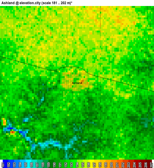
Below is the Elevation map of Ashland, which displays elevation range with different colors. Scale of the first map is from 181 to 202 m (594 to 663 ft) with average elevation of 192.5 meters (=632 ft) [note 1]
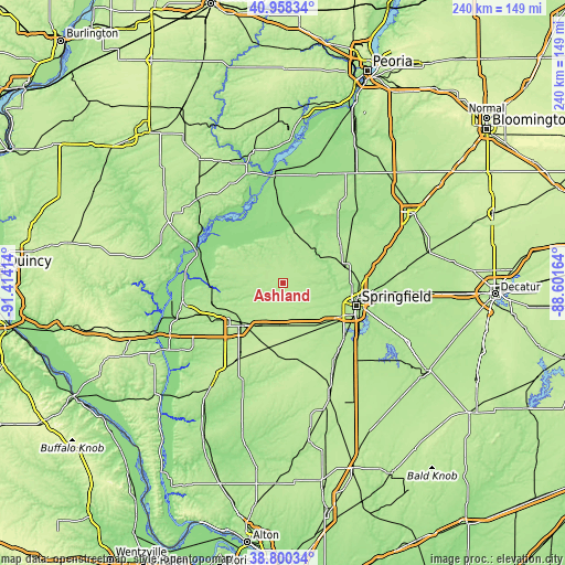
These maps also provides idea of topography and contour of this city, they are displayed at different zoom levels. More info about maps, scale and edge coordinates you can find below images.
| \ | Map #1 | Topo.Map |
| Scale [m] | 181..202 m | × |
| Scale [ft] | 594..663 ft | × |
| Average | 192.5 m = 632 ft | × |
| Width | 7.5 km = 4.7 mi | 239.9 km = 149.1 mi |
| Height | 7.5 km = 4.7 mi | 239.9 km = 149.1 mi |
| ↑Max Latitude | 39.921541° | 40.95834° |
| Latitude at center | 39.88783° | 39.88783° |
| ↓Min Latitude | 39.854102° | 38.80034° |
| ← Min Longitude | -90.051835° | -91.41414° |
| Longitude center | -90.00789° | -90.00789° |
| →Max Longitude | -89.963945° | -88.60164° |
Nearby cities:
Cities around Ashland sort by population:
• Springfield elevation 184 m
32.5 km,  107°
107°
• Jacksonville 190 m
25.5 km,  227°
227°
• South Jacksonville 191 m
27.4 km,  223°
223°
• Petersburg 157 m
19.4 km,  44°
44°
• Athens 184 m
25.5 km,  71°
71°
• Jerome 185 m
31 km,  115°
115°
• Southern View 189 m
33.5 km, 115°
• Leland Grove 187 m
30.6 km, 113°
• Virginia 189 m
18.8 km,  291°
291°
• Grandview 181 m
34.2 km,  103°
103°
• New Berlin 199 m
19.9 km,  155°
155°
• Waverly 210 m
33.3 km,  171°
171°
Multilingual:
 En español:
Ashland elevación 194 m.
 En France:
Ashland élévation 194 m.


Sources and notes:
- [note 1] Map square and city borders are not equal. Map elevation data is calculated only from area inside that square.
- [src 1] Elevation data from geonames database provided with same terms of usage.
- [src 2] The elevation map of Ashland is generated using elevation data from NASA's 3 arcsec (90m) resolution SRTM data.
- [src 3] Base (background) map © OpenStreetMap contributors tiles are generated by Geofabrik and OpenTopoMap.
Copyright & License:
This Ashland Elevation Map is licensed under CC BY-SA. You may reuse any part from this page, if you give a proper credit by linking to this URL:
 More info on terms of use page.