Albers elevation
Albers (Illinois, Clinton County), United States elevation is 135 meters and Albers elevation in feet is 443 ft above sea level [src 1]. Albers is a populated place (feature code) with elevation that is 144 meters (472 ft) smaller than average city elevation in United States.
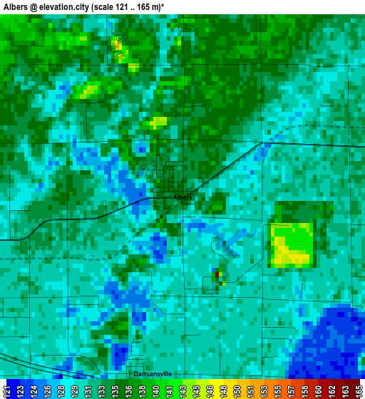
Below is the Elevation map of Albers, which displays elevation range with different colors. Scale of the first map is from 121 to 165 m (397 to 541 ft) with average elevation of 131.9 meters (=433 ft) [note 1]
These maps also provides idea of topography and contour of this city, they are displayed at different zoom levels. More info about maps, scale and edge coordinates you can find below images.
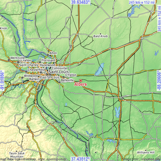
| \ | Map #1 | Topo.Map |
| Scale [m] | 121..165 m | × |
| Scale [ft] | 397..541 ft | × |
| Average | 131.9 m = 433 ft | × |
| Width | 7.64 km = 4.7 mi | 244.6 km = 152 mi |
| Height | 7.64 km = 4.7 mi | 244.6 km = 152 mi |
| ↑Max Latitude | 38.577743° | 39.63483° |
| Latitude at center | 38.54338° | 38.54338° |
| ↓Min Latitude | 38.509001° | 37.43512° |
| ← Min Longitude | -89.656255° | -91.01856° |
| Longitude center | -89.61231° | -89.61231° |
| →Max Longitude | -89.568365° | -88.20606° |
Nearby cities:
Cities around Albers sort by population:
• Highland elevation 162 m
22.4 km,  346°
346°
• Mascoutah 131 m
16.8 km,  249°
249°
• Breese 139 m
10.5 km,  44°
44°
• Lebanon 159 m
18.2 km,  291°
291°
• Scott Air Force Base 127 m
20.7 km,  269°
269°
• New Baden 141 m
7.7 km,  263°
263°
• Carlyle 137 m
22.1 km,  70°
70°
• Trenton 152 m
9.2 km,  318°
318°
• Aviston 146 m
7.1 km,  3°
3°
• Okawville 137 m
13.3 km,  156°
156°
• Germantown 133 m
6.5 km,  79°
79°
• Beckemeyer 140 m
16.8 km, 65°
Multilingual:
 En español:
Albers elevación 135 m.
 En France:
Albers élévation 135 m.


Sources and notes:
- [note 1] Map square and city borders are not equal. Map elevation data is calculated only from area inside that square.
- [src 1] Elevation data from geonames database provided with same terms of usage.
- [src 2] The elevation map of Albers is generated using elevation data from NASA's 3 arcsec (90m) resolution SRTM data.
- [src 3] Base (background) map © OpenStreetMap contributors tiles are generated by Geofabrik and OpenTopoMap.
Copyright & License:
This Albers Elevation Map is licensed under CC BY-SA. You may reuse any part from this page, if you give a proper credit by linking to this URL:
 More info on terms of use page.