West Point elevation
West Point (Georgia, Troup County), United States elevation is 178 meters and West Point elevation in feet is 584 ft above sea level [src 1]. West Point is a populated place (feature code) with elevation that is 101 meters (331 ft) smaller than average city elevation in United States.
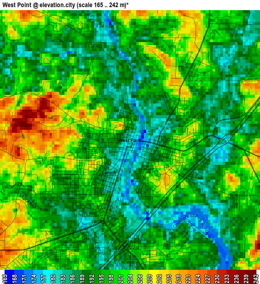
Below is the Elevation map of West Point, which displays elevation range with different colors. Scale of the first map is from 165 to 242 m (541 to 794 ft) with average elevation of 196.5 meters (=645 ft) [note 1]
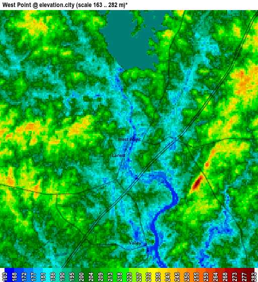
These maps also provides idea of topography and contour of this city, they are displayed at different zoom levels. More info about maps, scale and edge coordinates you can find below images.
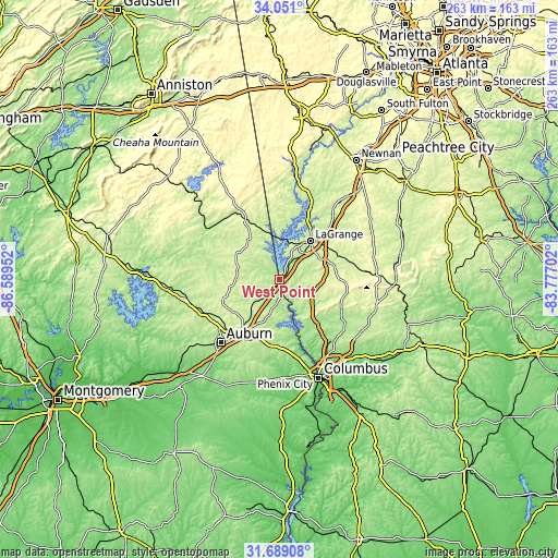
| \ | Map #1 | Map #2 | Topo.Map |
| Scale [m] | 165..242 m | 163..282 m | × |
| Scale [ft] | 541..794 ft | 535..925 ft | × |
| Average | 196.5 m = 645 ft | 203.4 m = 667 ft | × |
| Width | 8.21 km = 5.1 mi | 16.41 km = 10.2 mi | 262.6 km = 163.2 mi |
| Height | 8.21 km = 5.1 mi | 16.41 km = 10.2 mi | 262.6 km = 163.2 mi |
| ↑Max Latitude | 32.914809° | 32.951692° | 34.051° |
| Latitude at center | 32.87791° | 32.87791° | 32.87791° |
| ↓Min Latitude | 32.840996° | 32.804066° | 31.68908° |
| ← Min Longitude | -85.227215° | -85.271161° | -86.58952° |
| Longitude center | -85.18327° | -85.18327° | -85.18327° |
| →Max Longitude | -85.139325° | -85.095379° | -83.77702° |
Nearby cities:
Cities around West Point sort by population:
• Auburn elevation 220 m
40.8 km,  223°
223°
• LaGrange 243 m
22.9 km,  38°
38°
• Opelika 254 m
31.6 km, 215°
• Valley 184 m
6.6 km,  176°
176°
• Lanett 182 m
1.2 km,  213°
213°
• Roanoke 258 m
35.1 km,  329°
329°
• Smiths Station 165 m
38.4 km,  168°
168°
• Hogansville 215 m
41.3 km, 37°
• Lafayette 264 m
20.5 km,  276°
276°
• Huguley 216 m
6.5 km, 221°
• Pine Mountain 281 m
30.8 km,  92°
92°
• Hamilton 238 m
31.8 km,  114°
114°
Multilingual:
 En español:
West Point elevación 178 m.
 En France:
West Point élévation 178 m.
 Auf Deutsch:
West Point höhe über dem Meeresspiegel ist 178 m.

Sources and notes:
- [note 1] Map square and city borders are not equal. Map elevation data is calculated only from area inside that square.
- [src 1] Elevation data from geonames database provided with same terms of usage.
- [src 2] The elevation map of West Point is generated using elevation data from NASA's 3 arcsec (90m) resolution SRTM data.
- [src 3] Base (background) map © OpenStreetMap contributors tiles are generated by Geofabrik and OpenTopoMap.
Copyright & License:
This West Point Elevation Map is licensed under CC BY-SA. You may reuse any part from this page, if you give a proper credit by linking to this URL:
 More info on terms of use page.