Union Point elevation
Union Point (Georgia, Greene County), United States elevation is 214 meters and Union Point elevation in feet is 702 ft above sea level [src 1]. Union Point is a populated place (feature code) with elevation that is 65 meters (213 ft) smaller than average city elevation in United States.
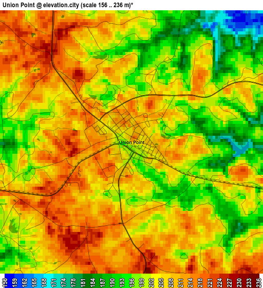
Below is the Elevation map of Union Point, which displays elevation range with different colors. Scale of the first map is from 156 to 236 m (512 to 774 ft) with average elevation of 204.6 meters (=671 ft) [note 1]
These maps also provides idea of topography and contour of this city, they are displayed at different zoom levels. More info about maps, scale and edge coordinates you can find below images.
| \ | Map #1 | Topo.Map |
| Scale [m] | 156..236 m | × |
| Scale [ft] | 512..774 ft | × |
| Average | 204.6 m = 671 ft | × |
| Width | 8.14 km = 5.1 mi | 260.4 km = 161.8 mi |
| Height | 8.14 km = 5.1 mi | 260.4 km = 161.8 mi |
| ↑Max Latitude | 33.652269° | 34.77876° |
| Latitude at center | 33.61568° | 33.61568° |
| ↓Min Latitude | 33.579076° | 32.43669° |
| ← Min Longitude | -83.118545° | -84.48085° |
| Longitude center | -83.0746° | -83.0746° |
| →Max Longitude | -83.030655° | -81.66835° |
Nearby cities:
Cities around Union Point sort by population:
• Eatonton elevation 175 m
43.4 km,  222°
222°
• Jefferson 171 m
28.7 km,  229°
229°
• Madison 209 m
36.5 km,  266°
266°
• Washington 189 m
33.8 km,  66°
66°
• Greensboro 198 m
10.9 km,  245°
245°
• Watkinsville 224 m
41.4 km,  311°
311°
• West Warrenton 149 m
43.4 km,  121°
121°
• Firing Range 183 m
40.7 km, 119°
• Mount Zion 165 m
29 km,  167°
167°
• Sparta 174 m
38.9 km, 166°
• Crawfordville 188 m
17.9 km,  112°
112°
• Lexington 213 m
28.5 km,  353°
353°
Multilingual:
 En español:
Union Point elevación 214 m.
 En France:
Union Point élévation 214 m.
 Auf Deutsch:
Union Point höhe über dem Meeresspiegel ist 214 m.

Sources and notes:
- [note 1] Map square and city borders are not equal. Map elevation data is calculated only from area inside that square.
- [src 1] Elevation data from geonames database provided with same terms of usage.
- [src 2] The elevation map of Union Point is generated using elevation data from NASA's 3 arcsec (90m) resolution SRTM data.
- [src 3] Base (background) map © OpenStreetMap contributors tiles are generated by Geofabrik and OpenTopoMap.
Copyright & License:
This Union Point Elevation Map is licensed under CC BY-SA. You may reuse any part from this page, if you give a proper credit by linking to this URL:
 More info on terms of use page.