Trion elevation
Trion (Georgia, Chattooga County), United States elevation is 203 meters and Trion elevation in feet is 666 ft above sea level [src 1]. Trion is a populated place (feature code) with elevation that is 76 meters (249 ft) smaller than average city elevation in United States.
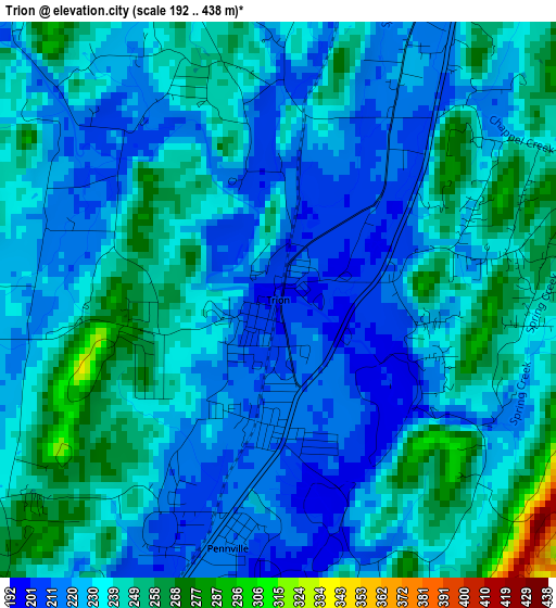
Below is the Elevation map of Trion, which displays elevation range with different colors. Scale of the first map is from 192 to 438 m (630 to 1437 ft) with average elevation of 233.9 meters (=767 ft) [note 1]
These maps also provides idea of topography and contour of this city, they are displayed at different zoom levels. More info about maps, scale and edge coordinates you can find below images.
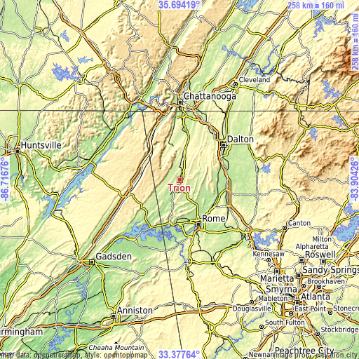
| \ | Map #1 | Topo.Map |
| Scale [m] | 192..438 m | × |
| Scale [ft] | 630..1437 ft | × |
| Average | 233.9 m = 767 ft | × |
| Width | 8.05 km = 5 mi | 257.6 km = 160.1 mi |
| Height | 8.05 km = 5 mi | 257.6 km = 160.1 mi |
| ↑Max Latitude | 34.580159° | 35.69419° |
| Latitude at center | 34.54397° | 34.54397° |
| ↓Min Latitude | 34.507765° | 33.37764° |
| ← Min Longitude | -85.354455° | -86.71676° |
| Longitude center | -85.31051° | -85.31051° |
| →Max Longitude | -85.266565° | -83.90426° |
Nearby cities:
Cities around Trion sort by population:
• Rome elevation 190 m
34.6 km,  157°
157°
• Dalton 232 m
40 km,  51°
51°
• Calhoun 207 m
33.2 km,  97°
97°
• Fort Payne 278 m
39.1 km,  253°
253°
• LaFayette 249 m
18.1 km,  8°
8°
• Adairsville 226 m
39.6 km,  119°
119°
• Summerville 199 m
7.8 km,  205°
205°
• Lindale 205 m
41.6 km, 162°
• Chickamauga 225 m
36.4 km,  2°
2°
• Henagar 446 m
43 km,  283°
283°
• Trenton 227 m
40.7 km,  333°
333°
• Shannon 212 m
31.8 km,  136°
136°
Multilingual:
 En español:
Trion elevación 203 m.
 En France:
Trion élévation 203 m.


Sources and notes:
- [note 1] Map square and city borders are not equal. Map elevation data is calculated only from area inside that square.
- [src 1] Elevation data from geonames database provided with same terms of usage.
- [src 2] The elevation map of Trion is generated using elevation data from NASA's 3 arcsec (90m) resolution SRTM data.
- [src 3] Base (background) map © OpenStreetMap contributors tiles are generated by Geofabrik and OpenTopoMap.
Copyright & License:
This Trion Elevation Map is licensed under CC BY-SA. You may reuse any part from this page, if you give a proper credit by linking to this URL:
 More info on terms of use page.