McDonough elevation
McDonough (Georgia, Henry County), United States elevation is 267 meters and McDonough elevation in feet is 876 ft above sea level [src 1]. McDonough is a seat of a second-order administrative division (feature code) with elevation that is 12 meters (39 ft) smaller than average city elevation in United States.
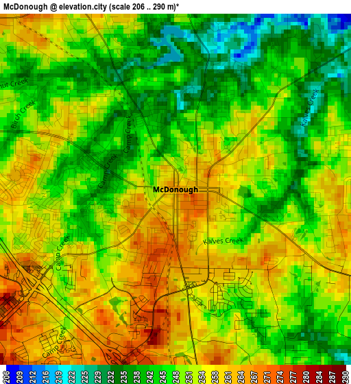
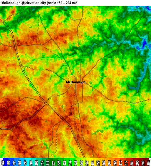
Below is the Elevation map of McDonough, which displays elevation range with different colors. Scale of the first map is from 206 to 290 m (676 to 951 ft) with average elevation of 250.4 meters (=822 ft) [note 1]
These maps also provides idea of topography and contour of this city, they are displayed at different zoom levels. More info about maps, scale and edge coordinates you can find below images.
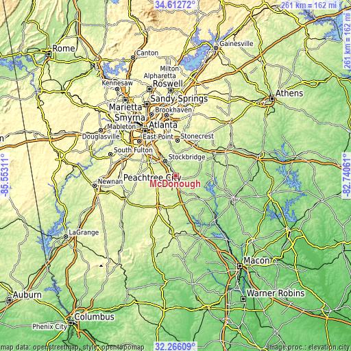
| \ | Map #1 | Map #2 | Topo.Map |
| Scale [m] | 206..290 m | 182..294 m | × |
| Scale [ft] | 676..951 ft | 597..965 ft | × |
| Average | 250.4 m = 822 ft | 248 m = 814 ft | × |
| Width | 8.15 km = 5.1 mi | 16.31 km = 10.1 mi | 260.9 km = 162.1 mi |
| Height | 8.15 km = 5.1 mi | 16.31 km = 10.1 mi | 260.9 km = 162.1 mi |
| ↑Max Latitude | 33.484° | 33.520644° | 34.61272° |
| Latitude at center | 33.44734° | 33.44734° | 33.44734° |
| ↓Min Latitude | 33.410665° | 33.373974° | 32.26609° |
| ← Min Longitude | -84.190805° | -84.234751° | -85.55311° |
| Longitude center | -84.14686° | -84.14686° | -84.14686° |
| →Max Longitude | -84.102915° | -84.058969° | -82.74061° |
Nearby cities:
Cities around McDonough sort by population:
• Stockbridge elevation 247 m
13.5 km,  323°
323°
• Irondale 263 m
20 km,  280°
280°
• Hampton 273 m
14.3 km,  242°
242°
• Morrow 281 m
23.4 km,  310°
310°
• Lovejoy 292 m
15.6 km,  265°
265°
• Locust Grove 258 m
11.8 km,  162°
162°
• Jackson 219 m
23.9 km,  135°
135°
• Jonesboro 284 m
20.9 km,  293°
293°
• Oakwood 235 m
19.5 km,  54°
54°
• Bonanza 273 m
17.7 km, 276°
• Experiment 292 m
23.8 km,  211°
211°
• East Griffin 272 m
23.9 km,  198°
198°
Multilingual:
 En español:
McDonough elevación 267 m.
 En France:
McDonough élévation 267 m.
 Auf Deutsch:
McDonough höhe über dem Meeresspiegel ist 267 m.

Sources and notes:
- [note 1] Map square and city borders are not equal. Map elevation data is calculated only from area inside that square.
- [src 1] Elevation data from geonames database provided with same terms of usage.
- [src 2] The elevation map of McDonough is generated using elevation data from NASA's 3 arcsec (90m) resolution SRTM data.
- [src 3] Base (background) map © OpenStreetMap contributors tiles are generated by Geofabrik and OpenTopoMap.
Copyright & License:
This McDonough Elevation Map is licensed under CC BY-SA. You may reuse any part from this page, if you give a proper credit by linking to this URL:
 More info on terms of use page.