McCaysville elevation
McCaysville (Georgia, Fannin County), United States elevation is 450 meters and McCaysville elevation in feet is 1476 ft above sea level [src 1]. McCaysville is a populated place (feature code) with elevation that is 171 meters (561 ft) bigger than average city elevation in United States.
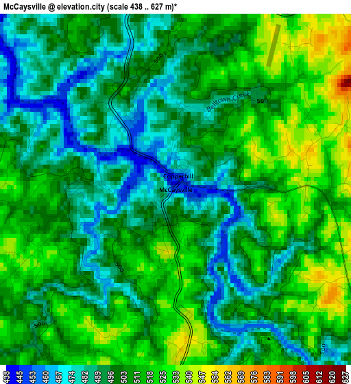
Below is the Elevation map of McCaysville, which displays elevation range with different colors. Scale of the first map is from 438 to 627 m (1437 to 2057 ft) with average elevation of 503.4 meters (=1652 ft) [note 1]
These maps also provides idea of topography and contour of this city, they are displayed at different zoom levels. More info about maps, scale and edge coordinates you can find below images.
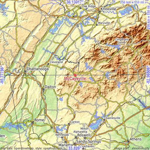
| \ | Map #1 | Topo.Map |
| Scale [m] | 438..627 m | × |
| Scale [ft] | 1437..2057 ft | × |
| Average | 503.4 m = 1652 ft | × |
| Width | 8.01 km = 5 mi | 256.2 km = 159.2 mi |
| Height | 8.01 km = 5 mi | 256.2 km = 159.2 mi |
| ↑Max Latitude | 35.022186° | 36.13017° |
| Latitude at center | 34.98619° | 34.98619° |
| ↓Min Latitude | 34.950178° | 33.826° |
| ← Min Longitude | -84.415255° | -85.77756° |
| Longitude center | -84.37131° | -84.37131° |
| →Max Longitude | -84.327365° | -82.96506° |
Nearby cities:
Cities around McCaysville sort by population:
• Cleveland elevation 261 m
49.9 km,  292°
292°
• South Cleveland 284 m
48.7 km, 290°
• Chatsworth 227 m
43.8 km,  236°
236°
• Etowah 244 m
40 km,  339°
339°
• Wildwood Lake 254 m
45.5 km,  284°
284°
• Ellijay 392 m
33.9 km,  197°
197°
• Murphy 484 m
32.7 km,  69°
69°
• East Cleveland 295 m
48.3 km, 293°
• Young Harris 585 m
48.1 km,  97°
97°
• Benton 225 m
33.1 km,  309°
309°
• Blue Ridge 535 m
14.3 km,  162°
162°
• Blairsville 577 m
39.6 km,  107°
107°
Multilingual:
 En español:
McCaysville elevación 450 m.
 En France:
McCaysville élévation 450 m.
 Auf Deutsch:
McCaysville höhe über dem Meeresspiegel ist 450 m.

Sources and notes:
- [note 1] Map square and city borders are not equal. Map elevation data is calculated only from area inside that square.
- [src 1] Elevation data from geonames database provided with same terms of usage.
- [src 2] The elevation map of McCaysville is generated using elevation data from NASA's 3 arcsec (90m) resolution SRTM data.
- [src 3] Base (background) map © OpenStreetMap contributors tiles are generated by Geofabrik and OpenTopoMap.
Copyright & License:
This McCaysville Elevation Map is licensed under CC BY-SA. You may reuse any part from this page, if you give a proper credit by linking to this URL:
 More info on terms of use page.