Manchester elevation
Manchester (Georgia, Meriwether County), United States elevation is 268 meters and Manchester elevation in feet is 879 ft above sea level [src 1]. Manchester is a populated place (feature code) with elevation that is 11 meters (36 ft) smaller than average city elevation in United States.
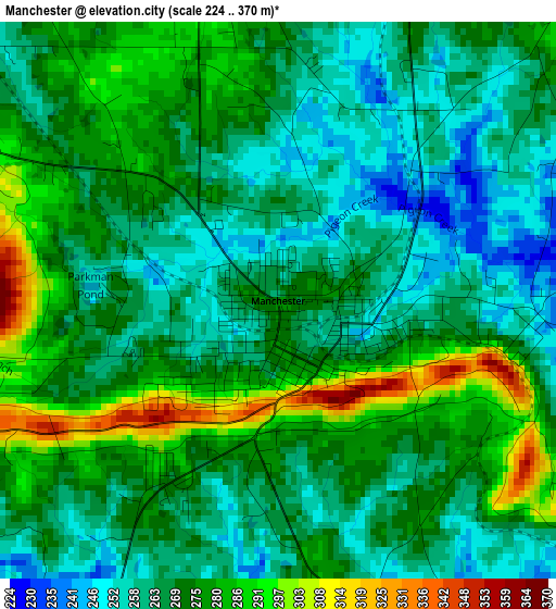
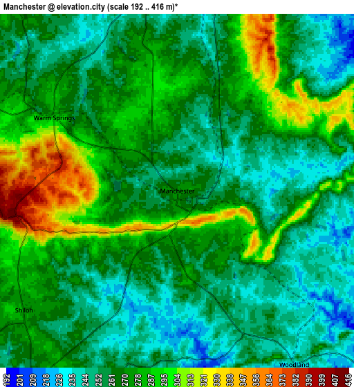
Below is the Elevation map of Manchester, which displays elevation range with different colors. Scale of the first map is from 224 to 370 m (735 to 1214 ft) with average elevation of 270.4 meters (=887 ft) [note 1]
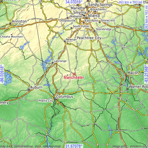
These maps also provides idea of topography and contour of this city, they are displayed at different zoom levels. More info about maps, scale and edge coordinates you can find below images.
| \ | Map #1 | Map #2 | Topo.Map |
| Scale [m] | 224..370 m | 192..416 m | × |
| Scale [ft] | 735..1214 ft | 630..1365 ft | × |
| Average | 270.4 m = 887 ft | 268.9 m = 882 ft | × |
| Width | 8.21 km = 5.1 mi | 16.42 km = 10.2 mi | 262.7 km = 163.2 mi |
| Height | 8.21 km = 5.1 mi | 16.42 km = 10.2 mi | 262.7 km = 163.2 mi |
| ↑Max Latitude | 32.896756° | 32.933647° | 34.03319° |
| Latitude at center | 32.85985° | 32.85985° | 32.85985° |
| ↓Min Latitude | 32.822928° | 32.785991° | 31.67078° |
| ← Min Longitude | -84.663875° | -84.707821° | -86.02618° |
| Longitude center | -84.61993° | -84.61993° | -84.61993° |
| →Max Longitude | -84.575985° | -84.532039° | -83.21368° |
Nearby cities:
Cities around Manchester sort by population:
• LaGrange elevation 243 m
43.3 km,  297°
297°
• Thomaston 233 m
27.6 km,  83°
83°
• Barnesville 264 m
48.4 km,  63°
63°
• Hannahs Mill 229 m
26.5 km,  72°
72°
• Grantville 267 m
46.3 km,  334°
334°
• Hogansville 215 m
44.4 km,  321°
321°
• Pine Mountain 281 m
21.9 km,  271°
271°
• Sardis 251 m
7.3 km,  194°
194°
• Hamilton 238 m
26.4 km,  244°
244°
• Zebulon 267 m
37.4 km,  43°
43°
• Talbotton 216 m
21.6 km,  159°
159°
• Greenville 268 m
20.7 km,  335°
335°
Multilingual:
 En español:
Manchester elevación 268 m.
 En France:
Manchester élévation 268 m.
 Auf Deutsch:
Manchester höhe über dem Meeresspiegel ist 268 m.

Sources and notes:
- [note 1] Map square and city borders are not equal. Map elevation data is calculated only from area inside that square.
- [src 1] Elevation data from geonames database provided with same terms of usage.
- [src 2] The elevation map of Manchester is generated using elevation data from NASA's 3 arcsec (90m) resolution SRTM data.
- [src 3] Base (background) map © OpenStreetMap contributors tiles are generated by Geofabrik and OpenTopoMap.
Copyright & License:
This Manchester Elevation Map is licensed under CC BY-SA. You may reuse any part from this page, if you give a proper credit by linking to this URL:
 More info on terms of use page.