Fayetteville elevation
Fayetteville (Georgia, Fayette County), United States elevation is 289 meters and Fayetteville elevation in feet is 948 ft above sea level [src 1]. Fayetteville is a seat of a second-order administrative division (feature code) with elevation that is 10 meters (33 ft) bigger than average city elevation in United States.
Below is the Elevation map of Fayetteville, which displays elevation range with different colors. Scale of the first map is from 242 to 306 m (794 to 1004 ft) with average elevation of 271.4 meters (=890 ft) [note 1]
These maps also provides idea of topography and contour of this city, they are displayed at different zoom levels. More info about maps, scale and edge coordinates you can find below images.
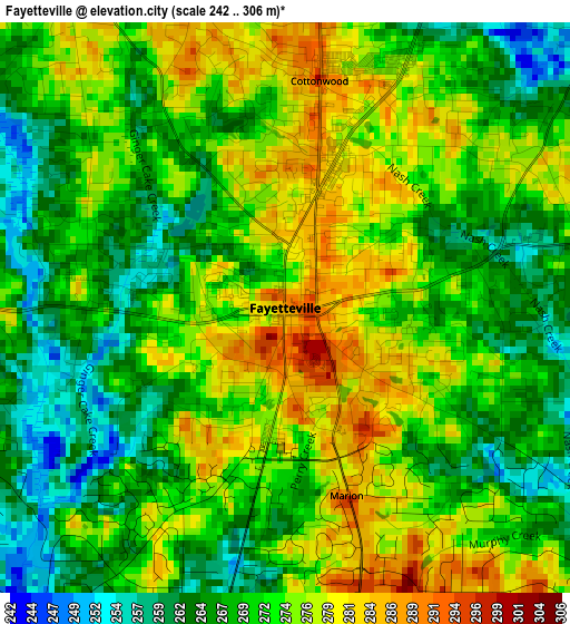
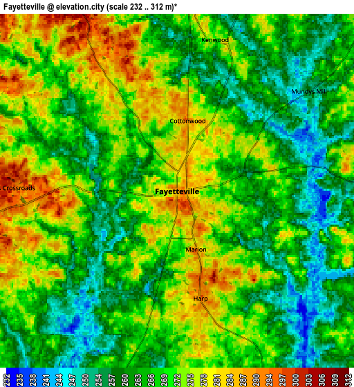

| \ | Map #1 | Map #2 | Topo.Map |
| Scale [m] | 242..306 m | 232..312 m | × |
| Scale [ft] | 794..1004 ft | 761..1024 ft | × |
| Average | 271.4 m = 890 ft | 268 m = 879 ft | × |
| Width | 8.15 km = 5.1 mi | 16.31 km = 10.1 mi | 260.9 km = 162.1 mi |
| Height | 8.15 km = 5.1 mi | 16.31 km = 10.1 mi | 260.9 km = 162.1 mi |
| ↑Max Latitude | 33.485389° | 33.522033° | 34.61409° |
| Latitude at center | 33.44873° | 33.44873° | 33.44873° |
| ↓Min Latitude | 33.412055° | 33.375365° | 32.26749° |
| ← Min Longitude | -84.498875° | -84.542821° | -85.86118° |
| Longitude center | -84.45493° | -84.45493° | -84.45493° |
| →Max Longitude | -84.410985° | -84.367039° | -83.04868° |
Nearby cities:
Cities around Fayetteville sort by population:
• Peachtree City elevation 273 m
14.3 km,  246°
246°
• Union City 299 m
17.4 km,  332°
332°
• Riverdale 285 m
14.3 km,  15°
15°
• Fairburn 316 m
17.6 km,  318°
318°
• Irondale 263 m
9.6 km,  68°
68°
• Hampton 273 m
17.4 km,  113°
113°
• Morrow 281 m
18.4 km,  35°
35°
• Tyrone 299 m
13.4 km,  280°
280°
• Lovejoy 292 m
13.1 km,  96°
96°
• Jonesboro 284 m
12.4 km,  49°
49°
• Bonanza 273 m
11.1 km,  80°
80°
• Shannon 258 m
5.1 km,  194°
194°
Multilingual:
 En español:
Fayetteville elevación 289 m.
 En France:
Fayetteville élévation 289 m.
 Auf Deutsch:
Fayetteville höhe über dem Meeresspiegel ist 289 m.

Sources and notes:
- [note 1] Map square and city borders are not equal. Map elevation data is calculated only from area inside that square.
- [src 1] Elevation data from geonames database provided with same terms of usage.
- [src 2] The elevation map of Fayetteville is generated using elevation data from NASA's 3 arcsec (90m) resolution SRTM data.
- [src 3] Base (background) map © OpenStreetMap contributors tiles are generated by Geofabrik and OpenTopoMap.
Copyright & License:
This Fayetteville Elevation Map is licensed under CC BY-SA. You may reuse any part from this page, if you give a proper credit by linking to this URL:
 More info on terms of use page.