Canton elevation
Canton (Georgia, Cherokee County), United States elevation is 296 meters and Canton elevation in feet is 971 ft above sea level [src 1]. Canton is a seat of a second-order administrative division (feature code) with elevation that is 17 meters (56 ft) bigger than average city elevation in United States.
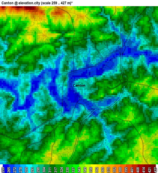
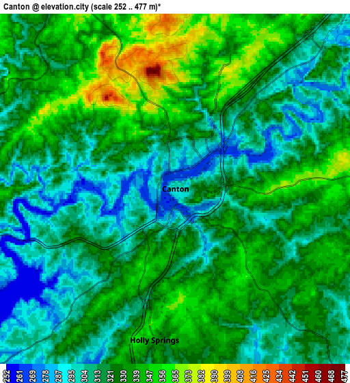
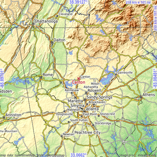
Below is the Elevation map of Canton, which displays elevation range with different colors. Scale of the first map is from 259 to 427 m (850 to 1401 ft) with average elevation of 312.8 meters (=1026 ft) [note 1]
These maps also provides idea of topography and contour of this city, they are displayed at different zoom levels. More info about maps, scale and edge coordinates you can find below images.
| \ | Map #1 | Map #2 | Topo.Map |
| Scale [m] | 259..427 m | 252..477 m | × |
| Scale [ft] | 850..1401 ft | 827..1565 ft | × |
| Average | 312.8 m = 1026 ft | 324 m = 1063 ft | × |
| Width | 8.08 km = 5 mi | 16.16 km = 10 mi | 258.5 km = 160.6 mi |
| Height | 8.08 km = 5 mi | 16.16 km = 10 mi | 258.5 km = 160.6 mi |
| ↑Max Latitude | 34.273083° | 34.30939° | 35.39127° |
| Latitude at center | 34.23676° | 34.23676° | 34.23676° |
| ↓Min Latitude | 34.200422° | 34.164068° | 33.0662° |
| ← Min Longitude | -84.534705° | -84.578651° | -85.89701° |
| Longitude center | -84.49076° | -84.49076° | -84.49076° |
| →Max Longitude | -84.446815° | -84.402869° | -83.08451° |
Nearby cities:
Cities around Canton sort by population:
• Roswell elevation 333 m
26.6 km,  153°
153°
• Alpharetta 348 m
25.5 km,  134°
134°
• Milton 305 m
21 km,  123°
123°
• Kennesaw 331 m
26.4 km,  205°
205°
• Woodstock 298 m
15.3 km,  189°
189°
• Acworth 277 m
25.6 km,  222°
222°
• Holly Springs 342 m
7 km, 187°
• Rydal 265 m
23.4 km,  297°
297°
• Jasper 450 m
26.3 km,  12°
12°
• Ball Ground 337 m
15.4 km,  42°
42°
• Emerson 253 m
27.2 km,  243°
243°
• Nelson 379 m
19.5 km,  34°
34°
Multilingual:
 En español:
Canton elevación 296 m.
 En France:
Canton élévation 296 m.


Sources and notes:
- [note 1] Map square and city borders are not equal. Map elevation data is calculated only from area inside that square.
- [src 1] Elevation data from geonames database provided with same terms of usage.
- [src 2] The elevation map of Canton is generated using elevation data from NASA's 3 arcsec (90m) resolution SRTM data.
- [src 3] Base (background) map © OpenStreetMap contributors tiles are generated by Geofabrik and OpenTopoMap.
Copyright & License:
This Canton Elevation Map is licensed under CC BY-SA. You may reuse any part from this page, if you give a proper credit by linking to this URL:
 More info on terms of use page.