Broxton elevation
Broxton (Georgia, Coffee County), United States elevation is 89 meters and Broxton elevation in feet is 292 ft above sea level [src 1]. Broxton is a populated place (feature code) with elevation that is 190 meters (623 ft) smaller than average city elevation in United States.
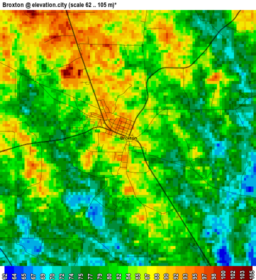
Below is the Elevation map of Broxton, which displays elevation range with different colors. Scale of the first map is from 62 to 105 m (203 to 344 ft) with average elevation of 81 meters (=266 ft) [note 1]
These maps also provides idea of topography and contour of this city, they are displayed at different zoom levels. More info about maps, scale and edge coordinates you can find below images.
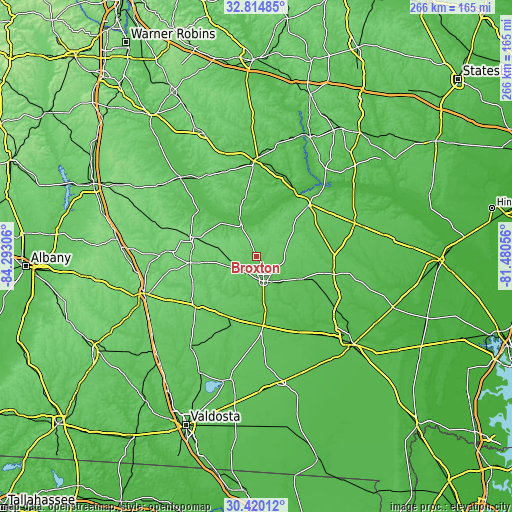
| \ | Map #1 | Topo.Map |
| Scale [m] | 62..105 m | × |
| Scale [ft] | 203..344 ft | × |
| Average | 81 m = 266 ft | × |
| Width | 8.32 km = 5.2 mi | 266.3 km = 165.5 mi |
| Height | 8.32 km = 5.2 mi | 266.3 km = 165.5 mi |
| ↑Max Latitude | 31.662602° | 32.81485° |
| Latitude at center | 31.62519° | 31.62519° |
| ↓Min Latitude | 31.587763° | 30.42012° |
| ← Min Longitude | -82.930755° | -84.29306° |
| Longitude center | -82.88681° | -82.88681° |
| →Max Longitude | -82.842865° | -81.48056° |
Nearby cities:
Cities around Broxton sort by population:
• Douglas elevation 80 m
13.4 km,  164°
164°
• Fitzgerald 110 m
36 km,  286°
286°
• McRae 76 m
49.2 km,  358°
358°
• Hazlehurst 80 m
38.8 km,  45°
45°
• Alma 62 m
41.3 km,  103°
103°
• Ocilla 109 m
34.7 km,  264°
264°
• Nicholls 63 m
26.7 km,  116°
116°
• Helena 74 m
49.9 km, 356°
• Pearson 65 m
36.6 km,  174°
174°
• Willacoochee 78 m
35 km,  205°
205°
• Enigma 97 m
48.1 km,  240°
240°
• Lumber City 48 m
39.1 km,  30°
30°
Multilingual:
 En español:
Broxton elevación 89 m.
 En France:
Broxton élévation 89 m.


Sources and notes:
- [note 1] Map square and city borders are not equal. Map elevation data is calculated only from area inside that square.
- [src 1] Elevation data from geonames database provided with same terms of usage.
- [src 2] The elevation map of Broxton is generated using elevation data from NASA's 3 arcsec (90m) resolution SRTM data.
- [src 3] Base (background) map © OpenStreetMap contributors tiles are generated by Geofabrik and OpenTopoMap.
Copyright & License:
This Broxton Elevation Map is licensed under CC BY-SA. You may reuse any part from this page, if you give a proper credit by linking to this URL:
 More info on terms of use page.