Wedgefield elevation
Wedgefield (Florida, Orange County), United States elevation is 23 meters and Wedgefield elevation in feet is 75 ft above sea level [src 1]. Wedgefield is a populated place (feature code) with elevation that is 256 meters (840 ft) smaller than average city elevation in United States.
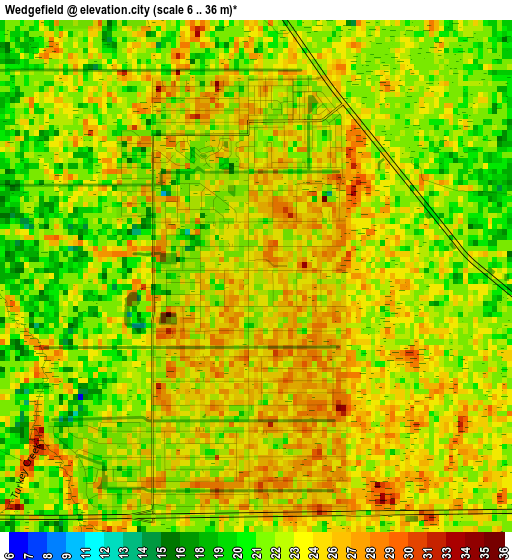
Below is the Elevation map of Wedgefield, which displays elevation range with different colors. Scale of the first map is from 6 to 36 m (20 to 118 ft) with average elevation of 23.3 meters (=76 ft) [note 1]
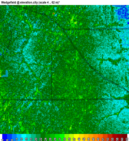
These maps also provides idea of topography and contour of this city, they are displayed at different zoom levels. More info about maps, scale and edge coordinates you can find below images.
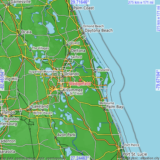
| \ | Map #1 | Map #2 | Topo.Map |
| Scale [m] | 6..36 m | 4..62 m | × |
| Scale [ft] | 20..118 ft | 13..203 ft | × |
| Average | 23.3 m = 76 ft | 21.9 m = 72 ft | × |
| Width | 8.59 km = 5.3 mi | 17.18 km = 10.7 mi | 274.8 km = 170.8 mi |
| Height | 8.59 km = 5.3 mi | 17.18 km = 10.7 mi | 274.8 km = 170.8 mi |
| ↑Max Latitude | 28.526397° | 28.565° | 29.71646° |
| Latitude at center | 28.48778° | 28.48778° | 28.48778° |
| ↓Min Latitude | 28.449149° | 28.410503° | 27.24463° |
| ← Min Longitude | -81.121235° | -81.165181° | -82.48354° |
| Longitude center | -81.07729° | -81.07729° | -81.07729° |
| →Max Longitude | -81.033345° | -80.989399° | -79.67104° |
Nearby cities:
Cities around Wedgefield sort by population:
• Alafaya elevation 31 m
15.6 km,  302°
302°
• Oviedo 19 m
24 km,  327°
327°
• Conway 36 m
24.8 km,  273°
273°
• Azalea Park 32 m
22.6 km,  285°
285°
• Port Saint John 11 m
28.2 km,  92°
92°
• Goldenrod 30 m
24.7 km, 303°
• Union Park 26 m
22.3 km, 293°
• Bithlo 22 m
8 km,  339°
339°
• Belle Isle 38 m
27.8 km,  263°
263°
• Geneva 24 m
28.3 km,  352°
352°
• Chuluota 22 m
17.7 km, 345°
• Christmas 17 m
8 km,  47°
47°
Multilingual:
 En español:
Wedgefield elevación 23 m.
 En France:
Wedgefield élévation 23 m.
 Auf Deutsch:
Wedgefield höhe über dem Meeresspiegel ist 23 m.

Sources and notes:
- [note 1] Map square and city borders are not equal. Map elevation data is calculated only from area inside that square.
- [src 1] Elevation data from geonames database provided with same terms of usage.
- [src 2] The elevation map of Wedgefield is generated using elevation data from NASA's 3 arcsec (90m) resolution SRTM data.
- [src 3] Base (background) map © OpenStreetMap contributors tiles are generated by Geofabrik and OpenTopoMap.
Copyright & License:
This Wedgefield Elevation Map is licensed under CC BY-SA. You may reuse any part from this page, if you give a proper credit by linking to this URL:
 More info on terms of use page.