Oviedo elevation
Oviedo (Florida, Seminole County), United States elevation is 19 meters and Oviedo elevation in feet is 62 ft above sea level [src 1]. Oviedo is a populated place (feature code) with elevation that is 260 meters (853 ft) smaller than average city elevation in United States.
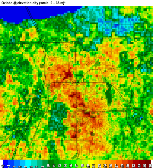
Below is the Elevation map of Oviedo, which displays elevation range with different colors. Scale of the first map is from -2 to 36 m (-7 to 118 ft) with average elevation of 16.3 meters (=53 ft) [note 1]
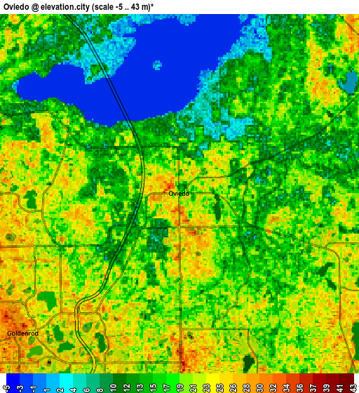
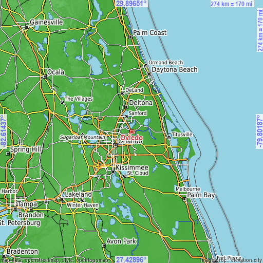
These maps also provides idea of topography and contour of this city, they are displayed at different zoom levels. More info about maps, scale and edge coordinates you can find below images.
| \ | Map #1 | Map #2 | Topo.Map |
| Scale [m] | -2..36 m | -5..43 m | × |
| Scale [ft] | -7..118 ft | -16..141 ft | × |
| Average | 16.3 m = 53 ft | 16.3 m = 53 ft | × |
| Width | 8.57 km = 5.3 mi | 17.15 km = 10.7 mi | 274.4 km = 170.5 mi |
| Height | 8.57 km = 5.3 mi | 17.15 km = 10.7 mi | 274.4 km = 170.5 mi |
| ↑Max Latitude | 28.70855° | 28.747087° | 29.89651° |
| Latitude at center | 28.67° | 28.67° | 28.67° |
| ↓Min Latitude | 28.631435° | 28.592857° | 27.42896° |
| ← Min Longitude | -81.252065° | -81.296011° | -82.61437° |
| Longitude center | -81.20812° | -81.20812° | -81.20812° |
| →Max Longitude | -81.164175° | -81.120229° | -79.80187° |
Nearby cities:
Cities around Oviedo sort by population:
• Alafaya elevation 31 m
11.8 km,  181°
181°
• Winter Springs 17 m
10.3 km,  288°
288°
• Winter Park 39 m
15 km,  238°
238°
• Casselberry 19 m
11.7 km,  274°
274°
• Lake Mary 23 m
14.6 km,  312°
312°
• Longwood 32 m
13.2 km, 286°
• Goldenrod 30 m
10.3 km,  229°
229°
• Union Park 26 m
13.7 km,  213°
213°
• Fern Park 32 m
14.1 km,  260°
260°
• Geneva 24 m
11.9 km,  49°
49°
• Chuluota 22 m
8.8 km,  110°
110°
• Midway 13 m
13.6 km,  350°
350°
Multilingual:
 En español:
Oviedo elevación 19 m.
 En France:
Oviedo élévation 19 m.


Sources and notes:
- [note 1] Map square and city borders are not equal. Map elevation data is calculated only from area inside that square.
- [src 1] Elevation data from geonames database provided with same terms of usage.
- [src 2] The elevation map of Oviedo is generated using elevation data from NASA's 3 arcsec (90m) resolution SRTM data.
- [src 3] Base (background) map © OpenStreetMap contributors tiles are generated by Geofabrik and OpenTopoMap.
Copyright & License:
This Oviedo Elevation Map is licensed under CC BY-SA. You may reuse any part from this page, if you give a proper credit by linking to this URL:
 More info on terms of use page.