Cantonment elevation
Cantonment (Florida, Escambia County), United States elevation is 50 meters and Cantonment elevation in feet is 164 ft above sea level [src 1]. Cantonment is a section of populated place (feature code) with elevation that is 229 meters (751 ft) smaller than average city elevation in United States.
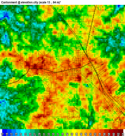
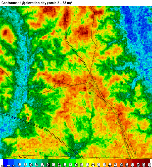
Below is the Elevation map of Cantonment, which displays elevation range with different colors. Scale of the first map is from 13 to 64 m (43 to 210 ft) with average elevation of 40.2 meters (=132 ft) [note 1]
These maps also provides idea of topography and contour of this city, they are displayed at different zoom levels. More info about maps, scale and edge coordinates you can find below images.
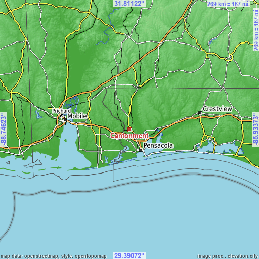
| \ | Map #1 | Map #2 | Topo.Map |
| Scale [m] | 13..64 m | 2..68 m | × |
| Scale [ft] | 43..210 ft | 7..223 ft | × |
| Average | 40.2 m = 132 ft | 34.1 m = 112 ft | × |
| Width | 8.41 km = 5.2 mi | 16.82 km = 10.5 mi | 269.1 km = 167.2 mi |
| Height | 8.41 km = 5.2 mi | 16.82 km = 10.5 mi | 269.1 km = 167.2 mi |
| ↑Max Latitude | 30.646345° | 30.684145° | 31.81122° |
| Latitude at center | 30.60853° | 30.60853° | 30.60853° |
| ↓Min Latitude | 30.5707° | 30.532856° | 29.39072° |
| ← Min Longitude | -87.383925° | -87.427871° | -88.74623° |
| Longitude center | -87.33998° | -87.33998° | -87.33998° |
| →Max Longitude | -87.296035° | -87.252089° | -85.93373° |
Nearby cities:
Cities around Cantonment sort by population:
• Pensacola elevation 24 m
23.9 km,  150°
150°
• Ferry Pass 45 m
16.4 km,  131°
131°
• Bellview 34 m
16.5 km,  171°
171°
• Brent 35 m
18.4 km, 147°
• West Pensacola 29 m
21 km,  164°
164°
• Ensley 45 m
11.9 km, 147°
• Pace 24 m
17.2 km,  93°
93°
• Myrtle Grove 24 m
21.1 km, 171°
• Gonzalez 57 m
5.5 km,  122°
122°
• Goulding 28 m
21.6 km, 148°
• Wallace 65 m
17.1 km,  63°
63°
• Molino 19 m
13.1 km,  10°
10°
Multilingual:
 En español:
Cantonment elevación 50 m.
 En France:
Cantonment élévation 50 m.
 Auf Deutsch:
Cantonment höhe über dem Meeresspiegel ist 50 m.

Sources and notes:
- [note 1] Map square and city borders are not equal. Map elevation data is calculated only from area inside that square.
- [src 1] Elevation data from geonames database provided with same terms of usage.
- [src 2] The elevation map of Cantonment is generated using elevation data from NASA's 3 arcsec (90m) resolution SRTM data.
- [src 3] Base (background) map © OpenStreetMap contributors tiles are generated by Geofabrik and OpenTopoMap.
Copyright & License:
This Cantonment Elevation Map is licensed under CC BY-SA. You may reuse any part from this page, if you give a proper credit by linking to this URL:
 More info on terms of use page.