Bagdad elevation
Bagdad (Florida, Santa Rosa County), United States elevation is 17 meters and Bagdad elevation in feet is 56 ft above sea level [src 1]. Bagdad is a populated place (feature code) with elevation that is 262 meters (860 ft) smaller than average city elevation in United States.
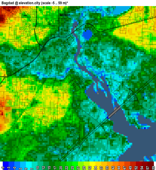
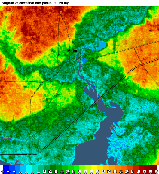
Below is the Elevation map of Bagdad, which displays elevation range with different colors. Scale of the first map is from -5 to 59 m (-16 to 194 ft) with average elevation of 18.6 meters (=61 ft) [note 1]
These maps also provides idea of topography and contour of this city, they are displayed at different zoom levels. More info about maps, scale and edge coordinates you can find below images.
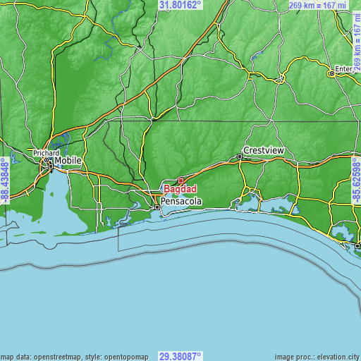
| \ | Map #1 | Map #2 | Topo.Map |
| Scale [m] | -5..59 m | -9..69 m | × |
| Scale [ft] | -16..194 ft | -30..226 ft | × |
| Average | 18.6 m = 61 ft | 25.5 m = 84 ft | × |
| Width | 8.41 km = 5.2 mi | 16.82 km = 10.5 mi | 269.2 km = 167.3 mi |
| Height | 8.41 km = 5.2 mi | 16.82 km = 10.5 mi | 269.2 km = 167.3 mi |
| ↑Max Latitude | 30.636619° | 30.674423° | 31.80162° |
| Latitude at center | 30.5988° | 30.5988° | 30.5988° |
| ↓Min Latitude | 30.560967° | 30.523118° | 29.38087° |
| ← Min Longitude | -87.076175° | -87.120121° | -88.43848° |
| Longitude center | -87.03223° | -87.03223° | -87.03223° |
| →Max Longitude | -86.988285° | -86.944339° | -85.62598° |
Nearby cities:
Cities around Bagdad sort by population:
• East Pensacola Heights elevation 21 m
23.6 km,  216°
216°
• Ferry Pass 45 m
19.9 km,  240°
240°
• Brent 35 m
24.3 km,  233°
233°
• Pace 24 m
12.3 km,  270°
270°
• Midway 11 m
21.5 km,  173°
173°
• East Milton 10 m
2.1 km,  29°
29°
• Milton 14 m
3.8 km,  349°
349°
• Tiger Point 8 m
24.6 km,  185°
185°
• Point Baker 64 m
10.4 km, 348°
• Woodlawn Beach 13 m
23.7 km, 170°
• Wallace 65 m
16.6 km,  301°
301°
• Holley 9 m
20.7 km,  144°
144°
Multilingual:
 En español:
Bagdad elevación 17 m.
 En France:
Bagdad élévation 17 m.


Sources and notes:
- [note 1] Map square and city borders are not equal. Map elevation data is calculated only from area inside that square.
- [src 1] Elevation data from geonames database provided with same terms of usage.
- [src 2] The elevation map of Bagdad is generated using elevation data from NASA's 3 arcsec (90m) resolution SRTM data.
- [src 3] Base (background) map © OpenStreetMap contributors tiles are generated by Geofabrik and OpenTopoMap.
Copyright & License:
This Bagdad Elevation Map is licensed under CC BY-SA. You may reuse any part from this page, if you give a proper credit by linking to this URL:
 More info on terms of use page.