Tuckerman elevation
Tuckerman (Arkansas, Jackson County), United States elevation is 74 meters and Tuckerman elevation in feet is 243 ft above sea level [src 1]. Tuckerman is a populated place (feature code) with elevation that is 205 meters (673 ft) smaller than average city elevation in United States.
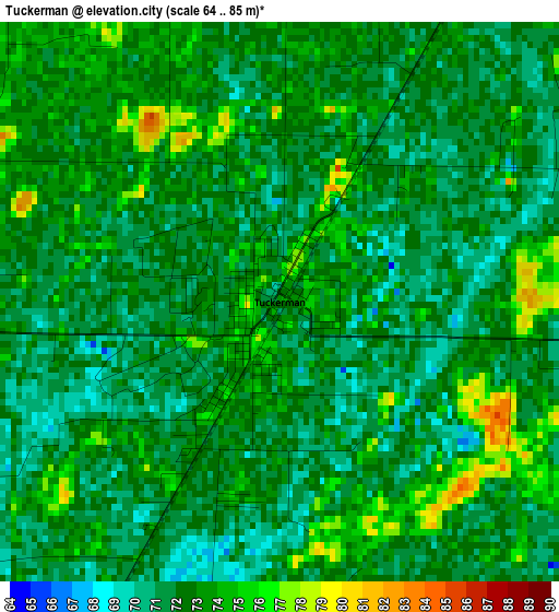
Below is the Elevation map of Tuckerman, which displays elevation range with different colors. Scale of the first map is from 64 to 85 m (210 to 279 ft) with average elevation of 72.1 meters (=237 ft) [note 1]
These maps also provides idea of topography and contour of this city, they are displayed at different zoom levels. More info about maps, scale and edge coordinates you can find below images.
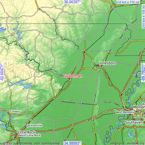
| \ | Map #1 | Topo.Map |
| Scale [m] | 64..85 m | × |
| Scale [ft] | 210..279 ft | × |
| Average | 72.1 m = 237 ft | × |
| Width | 7.93 km = 4.9 mi | 253.9 km = 157.8 mi |
| Height | 7.93 km = 4.9 mi | 253.8 km = 157.7 mi |
| ↑Max Latitude | 35.766296° | 36.86397° |
| Latitude at center | 35.73063° | 35.73063° |
| ↓Min Latitude | 35.694948° | 34.58093° |
| ← Min Longitude | -91.242405° | -92.60471° |
| Longitude center | -91.19846° | -91.19846° |
| →Max Longitude | -91.154515° | -89.79221° |
Nearby cities:
Cities around Tuckerman sort by population:
• Jonesboro elevation 96 m
46.3 km,  74°
74°
• Batesville 105 m
40.2 km,  276°
276°
• Newport 70 m
15.9 km,  208°
208°
• Walnut Ridge 82 m
43.4 km,  30°
30°
• Hoxie 79 m
40.8 km, 29°
• Harrisburg 94 m
47.3 km,  113°
113°
• Bono 79 m
40.8 km,  60°
60°
• Southside 107 m
38.5 km,  264°
264°
• Augusta 71 m
52.1 km,  196°
196°
• Cave City 204 m
39.3 km,  306°
306°
• Diaz 70 m
11.9 km, 210°
• Newark 87 m
22.2 km, 261°
Multilingual:
 En español:
Tuckerman elevación 74 m.
 En France:
Tuckerman élévation 74 m.
 Auf Deutsch:
Tuckerman höhe über dem Meeresspiegel ist 74 m.

Sources and notes:
- [note 1] Map square and city borders are not equal. Map elevation data is calculated only from area inside that square.
- [src 1] Elevation data from geonames database provided with same terms of usage.
- [src 2] The elevation map of Tuckerman is generated using elevation data from NASA's 3 arcsec (90m) resolution SRTM data.
- [src 3] Base (background) map © OpenStreetMap contributors tiles are generated by Geofabrik and OpenTopoMap.
Copyright & License:
This Tuckerman Elevation Map is licensed under CC BY-SA. You may reuse any part from this page, if you give a proper credit by linking to this URL:
 More info on terms of use page.