Stamps elevation
Stamps (Arkansas, Lafayette County), United States elevation is 101 meters and Stamps elevation in feet is 331 ft above sea level [src 1]. Stamps is a populated place (feature code) with elevation that is 178 meters (584 ft) smaller than average city elevation in United States.
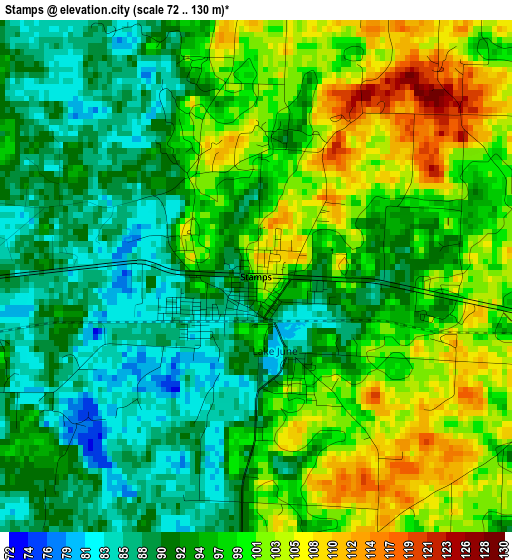
Below is the Elevation map of Stamps, which displays elevation range with different colors. Scale of the first map is from 72 to 130 m (236 to 427 ft) with average elevation of 95.6 meters (=314 ft) [note 1]
These maps also provides idea of topography and contour of this city, they are displayed at different zoom levels. More info about maps, scale and edge coordinates you can find below images.
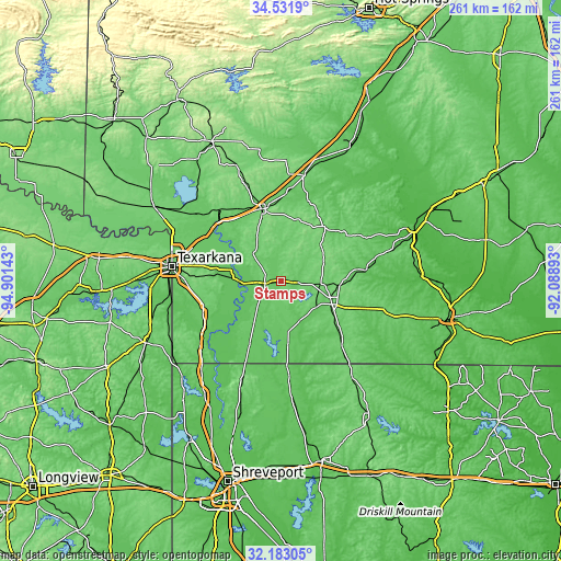
| \ | Map #1 | Topo.Map |
| Scale [m] | 72..130 m | × |
| Scale [ft] | 236..427 ft | × |
| Average | 95.6 m = 314 ft | × |
| Width | 8.16 km = 5.1 mi | 261.2 km = 162.3 mi |
| Height | 8.16 km = 5.1 mi | 261.2 km = 162.3 mi |
| ↑Max Latitude | 33.402095° | 34.5319° |
| Latitude at center | 33.3654° | 33.3654° |
| ↓Min Latitude | 33.32869° | 32.18305° |
| ← Min Longitude | -93.539125° | -94.90143° |
| Longitude center | -93.49518° | -93.49518° |
| →Max Longitude | -93.451235° | -92.08893° |
Nearby cities:
Cities around Stamps sort by population:
• Texarkana elevation 95 m
51.7 km,  277°
277°
• Texarkana 118 m
51.1 km, 279°
• Magnolia 106 m
26.2 km,  114°
114°
• Hope 112 m
34.7 km,  345°
345°
• Wake Village 106 m
57.1 km, 276°
• Springhill 93 m
40.1 km,  176°
176°
• Nash 112 m
59.6 km, 278°
• Prescott 106 m
49.8 km,  12°
12°
• Haynesville 114 m
55.7 km,  143°
143°
• Waldo 113 m
18.6 km,  94°
94°
• Lewisville 95 m
7.7 km,  264°
264°
• Cullen 76 m
44.3 km,  174°
174°
Multilingual:
 En español:
Stamps elevación 101 m.
 En France:
Stamps élévation 101 m.


Sources and notes:
- [note 1] Map square and city borders are not equal. Map elevation data is calculated only from area inside that square.
- [src 1] Elevation data from geonames database provided with same terms of usage.
- [src 2] The elevation map of Stamps is generated using elevation data from NASA's 3 arcsec (90m) resolution SRTM data.
- [src 3] Base (background) map © OpenStreetMap contributors tiles are generated by Geofabrik and OpenTopoMap.
Copyright & License:
This Stamps Elevation Map is licensed under CC BY-SA. You may reuse any part from this page, if you give a proper credit by linking to this URL:
 More info on terms of use page.