Helena elevation
Helena (Arkansas, Phillips County), United States elevation is 61 meters and Helena elevation in feet is 200 ft above sea level [src 1]. Helena is a seat of a second-order administrative division (feature code) with elevation that is 218 meters (715 ft) smaller than average city elevation in United States.
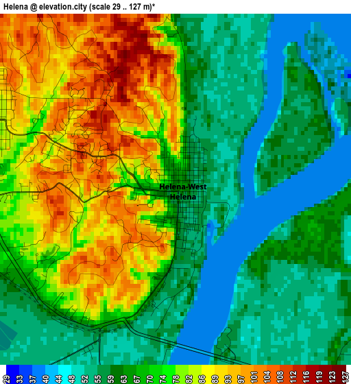
Below is the Elevation map of Helena, which displays elevation range with different colors. Scale of the first map is from 29 to 127 m (95 to 417 ft) with average elevation of 69.8 meters (=229 ft) [note 1]
These maps also provides idea of topography and contour of this city, they are displayed at different zoom levels. More info about maps, scale and edge coordinates you can find below images.
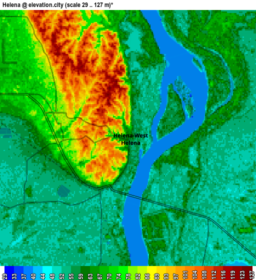
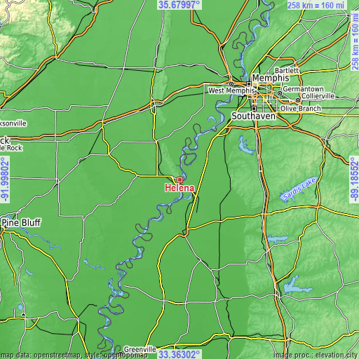
| \ | Map #1 | Map #2 | Topo.Map |
| Scale [m] | 29..127 m | 29..127 m | × |
| Scale [ft] | 95..417 ft | 95..417 ft | × |
| Average | 69.8 m = 229 ft | 63.4 m = 208 ft | × |
| Width | 8.05 km = 5 mi | 16.1 km = 10 mi | 257.6 km = 160.1 mi |
| Height | 8.05 km = 5 mi | 16.1 km = 10 mi | 257.6 km = 160.1 mi |
| ↑Max Latitude | 34.565746° | 34.601926° | 35.67997° |
| Latitude at center | 34.52955° | 34.52955° | 34.52955° |
| ↓Min Latitude | 34.493338° | 34.457111° | 33.36302° |
| ← Min Longitude | -90.635715° | -90.679661° | -91.99802° |
| Longitude center | -90.59177° | -90.59177° | -90.59177° |
| →Max Longitude | -90.547825° | -90.503879° | -89.18552° |
Nearby cities:
Cities around Helena sort by population:
• Clarksdale elevation 54 m
36.7 km,  177°
177°
• Helena-West Helena 62 m
0.2 km,  107°
107°
• West Helena 74 m
5.1 km,  297°
297°
• Marianna 71 m
31.1 km,  330°
330°
• Tunica Resorts 65 m
40.8 km,  33°
33°
• Marks 49 m
42.1 km,  136°
136°
• Lambert 48 m
46.1 km, 142°
• Jonestown 51 m
26.5 km,  151°
151°
• Friars Point 52 m
18.2 km,  193°
193°
• Marvell 62 m
29.6 km,  275°
275°
• North Tunica 60 m
27.3 km,  45°
45°
• Tunica 63 m
25.7 km, 47°
Multilingual:
 En español:
Helena elevación 61 m.
 En France:
Helena élévation 61 m.


Sources and notes:
- [note 1] Map square and city borders are not equal. Map elevation data is calculated only from area inside that square.
- [src 1] Elevation data from geonames database provided with same terms of usage.
- [src 2] The elevation map of Helena is generated using elevation data from NASA's 3 arcsec (90m) resolution SRTM data.
- [src 3] Base (background) map © OpenStreetMap contributors tiles are generated by Geofabrik and OpenTopoMap.
Copyright & License:
This Helena Elevation Map is licensed under CC BY-SA. You may reuse any part from this page, if you give a proper credit by linking to this URL:
 More info on terms of use page.