Taylor elevation
Taylor (Alabama, Montgomery County), United States elevation is 168 meters and Taylor elevation in feet is 551 ft above sea level [src 1]. Taylor is a populated place (feature code) with elevation that is 111 meters (364 ft) smaller than average city elevation in United States.
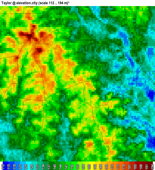
Below is the Elevation map of Taylor, which displays elevation range with different colors. Scale of the first map is from 112 to 194 m (367 to 636 ft) with average elevation of 145 meters (=476 ft) [note 1]
These maps also provides idea of topography and contour of this city, they are displayed at different zoom levels. More info about maps, scale and edge coordinates you can find below images.
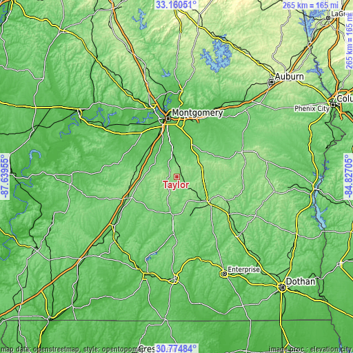
| \ | Map #1 | Topo.Map |
| Scale [m] | 112..194 m | × |
| Scale [ft] | 367..636 ft | × |
| Average | 145 m = 476 ft | × |
| Width | 8.29 km = 5.2 mi | 265.3 km = 164.8 mi |
| Height | 8.29 km = 5.2 mi | 265.3 km = 164.8 mi |
| ↑Max Latitude | 32.0127° | 33.16051° |
| Latitude at center | 31.97543° | 31.97543° |
| ↓Min Latitude | 31.938145° | 30.77484° |
| ← Min Longitude | -86.277245° | -87.63955° |
| Longitude center | -86.2333° | -86.2333° |
| →Max Longitude | -86.189355° | -84.82705° |
Nearby cities:
Cities around Taylor sort by population:
• Montgomery elevation 76 m
44 km,  351°
351°
• Troy 169 m
31 km,  126°
126°
• Millbrook 63 m
57.4 km, 347°
• Pike Road 95 m
36.5 km,  19°
19°
• Greenville 135 m
39.7 km,  245°
245°
• Union Springs 161 m
52.3 km,  68°
68°
• Luverne 111 m
28.9 km,  185°
185°
• Emerald Mountain 106 m
54.1 km,  13°
13°
• Brundidge 150 m
48.6 km, 125°
• Inverness 136 m
46.2 km,  84°
84°
• Fort Deposit 144 m
32.6 km,  271°
271°
• Hayneville 78 m
40.1 km,  305°
305°
Multilingual:
 En español:
Taylor elevación 168 m.
 En France:
Taylor élévation 168 m.


Sources and notes:
- [note 1] Map square and city borders are not equal. Map elevation data is calculated only from area inside that square.
- [src 1] Elevation data from geonames database provided with same terms of usage.
- [src 2] The elevation map of Taylor is generated using elevation data from NASA's 3 arcsec (90m) resolution SRTM data.
- [src 3] Base (background) map © OpenStreetMap contributors tiles are generated by Geofabrik and OpenTopoMap.
Copyright & License:
This Taylor Elevation Map is licensed under CC BY-SA. You may reuse any part from this page, if you give a proper credit by linking to this URL:
 More info on terms of use page.