Bashtanka elevation
Bashtanka (Mykolaiv), Ukraine elevation is 77 meters and Bashtanka elevation in feet is 253 ft above sea level [src 1]. Bashtanka is a seat of a second-order administrative division (feature code) with elevation that is 80 meters (262 ft) smaller than average city elevation in Ukraine.
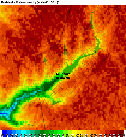
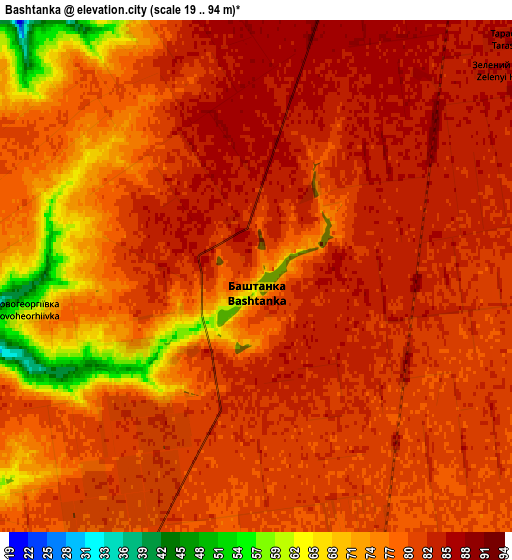
Below is the Elevation map of Bashtanka, which displays elevation range with different colors. Scale of the first map is from 46 to 90 m (151 to 295 ft) with average elevation of 80.4 meters (=264 ft) [note 1]
These maps also provides idea of topography and contour of this city, they are displayed at different zoom levels. More info about maps, scale and edge coordinates you can find below images.
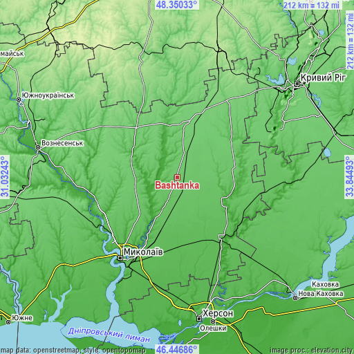
| \ | Map #1 | Map #2 | Topo.Map |
| Scale [m] | 46..90 m | 19..94 m | × |
| Scale [ft] | 151..295 ft | 62..308 ft | × |
| Average | 80.4 m = 264 ft | 79.1 m = 260 ft | × |
| Width | 6.61 km = 4.1 mi | 13.23 km = 8.2 mi | 211.6 km = 131.5 mi |
| Height | 6.61 km = 4.1 mi | 13.23 km = 8.2 mi | 211.6 km = 131.5 mi |
| ↑Max Latitude | 47.436923° | 47.466639° | 48.35033° |
| Latitude at center | 47.40719° | 47.40719° | 47.40719° |
| ↓Min Latitude | 47.37744° | 47.347673° | 46.44686° |
| ← Min Longitude | 32.394735° | 32.350789° | 31.03243° |
| Longitude center | 32.43868° | 32.43868° | 32.43868° |
| →Max Longitude | 32.482625° | 32.526571° | 33.84493° |
Nearby cities:
Cities around Bashtanka sort by population:
• Mykolayiv elevation 18 m
59.3 km,  214°
214°
• Novyy Buh 100 m
32.4 km,  11°
11°
• Snihurivka 51 m
46.1 km,  143°
143°
• Nova Odesa 25 m
50.5 km,  257°
257°
• Kazanka 92 m
56.6 km,  30°
30°
• Bereznehuvate 20 m
32.9 km,  109°
109°
• Velyka Oleksandrivka 45 m
65.9 km,  98°
98°
• Oleksandrivka 37 m
67.8 km,  158°
158°
• Ol'shanskoye 70 m
54.6 km,  242°
242°
• Ustynivka 84 m
61.4 km, 6°
• Shevchenkove 44 m
63.1 km,  196°
196°
• Yelanets’ 73 m
54.5 km,  306°
306°
Multilingual:
 En español:
Bashtanka elevación 77 m.
 En France:
Bachtanka élévation 77 m.
 Auf Deutsch:
Baschtanka höhe über dem Meeresspiegel ist 77 m.

Sources and notes:
- [note 1] Map square and city borders are not equal. Map elevation data is calculated only from area inside that square.
- [src 1] Elevation data from geonames database provided with same terms of usage.
- [src 2] The elevation map of Bashtanka is generated using elevation data from NASA's 3 arcsec (90m) resolution SRTM data.
- [src 3] Base (background) map © OpenStreetMap contributors tiles are generated by Geofabrik and OpenTopoMap.
Copyright & License:
This Bashtanka Elevation Map is licensed under CC BY-SA. You may reuse any part from this page, if you give a proper credit by linking to this URL:
 More info on terms of use page.