Mykolayiv elevation
Mykolayiv (Mykolaiv), Ukraine elevation is 18 meters and Mykolayiv elevation in feet is 59 ft above sea level [src 1]. Mykolayiv is a seat of a first-order administrative division (feature code) with elevation that is 139 meters (456 ft) smaller than average city elevation in Ukraine.
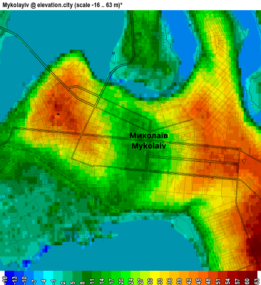
Below is the Elevation map of Mykolayiv, which displays elevation range with different colors. Scale of the first map is from -16 to 63 m (-52 to 207 ft) with average elevation of 16.9 meters (=55 ft) [note 1]
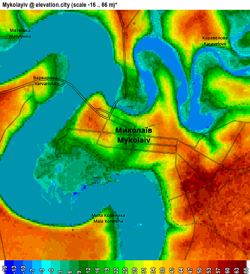
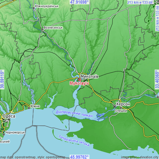
These maps also provides idea of topography and contour of this city, they are displayed at different zoom levels. More info about maps, scale and edge coordinates you can find below images.
| \ | Map #1 | Map #2 | Topo.Map |
| Scale [m] | -16..63 m | -16..66 m | × |
| Scale [ft] | -52..207 ft | -52..217 ft | × |
| Average | 16.9 m = 55 ft | 20.5 m = 67 ft | × |
| Width | 6.67 km = 4.1 mi | 13.34 km = 8.3 mi | 213.4 km = 132.6 mi |
| Height | 6.67 km = 4.1 mi | 13.34 km = 8.3 mi | 213.4 km = 132.6 mi |
| ↑Max Latitude | 46.995891° | 47.025856° | 47.91698° |
| Latitude at center | 46.96591° | 46.96591° | 46.96591° |
| ↓Min Latitude | 46.935912° | 46.905897° | 45.99762° |
| ← Min Longitude | 31.953455° | 31.909509° | 30.59115° |
| Longitude center | 31.9974° | 31.9974° | 31.9974° |
| →Max Longitude | 32.041345° | 32.085291° | 33.40365° |
Nearby cities:
Cities around Mykolayiv sort by population:
• Kherson elevation 51 m
58.5 km,  126°
126°
• Ochakiv 37 m
52 km,  220°
220°
• Nova Odesa 25 m
41.3 km,  337°
337°
• Bashtanka 77 m
59.3 km,  34°
34°
• Bilozerka 18 m
50.9 km,  138°
138°
• Chornobayivka 19 m
52 km, 125°
• Komyshany 23 m
53.3 km, 133°
• Stanislav 40 m
45.6 km,  165°
165°
• Ol'shanskoye 70 m
28.7 km,  327°
327°
• Berezanka 15 m
48 km,  254°
254°
• Shevchenkove 44 m
19.4 km, 126°
• Parutyne 28 m
30 km,  194°
194°
Multilingual:
 En español:
Mykolayiv elevación 18 m.
 En France:
Mykolayiv élévation 18 m.
 Auf Deutsch:
Mykolayiv höhe über dem Meeresspiegel ist 18 m.

Sources and notes:
- [note 1] Map square and city borders are not equal. Map elevation data is calculated only from area inside that square.
- [src 1] Elevation data from geonames database provided with same terms of usage.
- [src 2] The elevation map of Mykolayiv is generated using elevation data from NASA's 3 arcsec (90m) resolution SRTM data.
- [src 3] Base (background) map © OpenStreetMap contributors tiles are generated by Geofabrik and OpenTopoMap.
Copyright & License:
This Mykolayiv Elevation Map is licensed under CC BY-SA. You may reuse any part from this page, if you give a proper credit by linking to this URL:
 More info on terms of use page.