Inkerman elevation
Inkerman (Sevastopol City, Balaklava District), Ukraine elevation is 19 meters and Inkerman elevation in feet is 62 ft above sea level [src 1]. Inkerman is a seat of a third-order administrative division (feature code) with elevation that is 138 meters (453 ft) smaller than average city elevation in Ukraine.
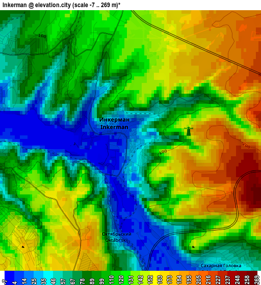
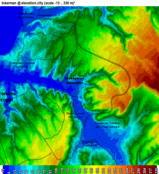
Below is the Elevation map of Inkerman, which displays elevation range with different colors. Scale of the first map is from -7 to 269 m (-23 to 883 ft) with average elevation of 111 meters (=364 ft) [note 1]
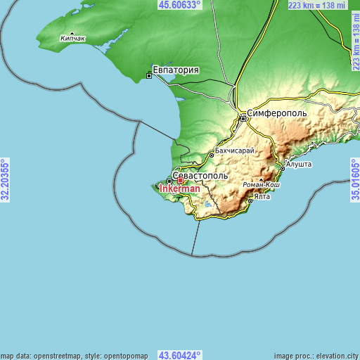
These maps also provides idea of topography and contour of this city, they are displayed at different zoom levels. More info about maps, scale and edge coordinates you can find below images.
| \ | Map #1 | Map #2 | Topo.Map |
| Scale [m] | -7..269 m | -13..330 m | × |
| Scale [ft] | -23..883 ft | -43..1083 ft | × |
| Average | 111 m = 364 ft | 110 m = 361 ft | × |
| Width | 6.96 km = 4.3 mi | 13.91 km = 8.6 mi | 222.6 km = 138.3 mi |
| Height | 6.96 km = 4.3 mi | 13.91 km = 8.6 mi | 222.6 km = 138.3 mi |
| ↑Max Latitude | 44.645184° | 44.676442° | 45.60633° |
| Latitude at center | 44.61391° | 44.61391° | 44.61391° |
| ↓Min Latitude | 44.582619° | 44.551311° | 43.60424° |
| ← Min Longitude | 33.565855° | 33.521909° | 32.20355° |
| Longitude center | 33.6098° | 33.6098° | 33.6098° |
| →Max Longitude | 33.653745° | 33.697691° | 35.01605° |
Nearby cities:
Cities around Inkerman sort by population:
• Sevastopol elevation 72 m
7.5 km,  248°
248°
• Balaklava 12 m
11.5 km,  184°
184°
• Sakharnaya Golovka 44 m
4.3 km,  141°
141°
• Verkhnesadovoye 69 m
11.1 km,  41°
41°
• Kholmovka 87 m
12.5 km,  66°
66°
• Polyushko 33 m
14.4 km,  353°
353°
• Ternovka 192 m
11.8 km,  109°
109°
• Krasnyi Mak 117 m
13.9 km,  76°
76°
• Tankovoye 150 m
16.5 km, 72°
• Shturmovoye 13 m
5.2 km,  168°
168°
• Tenistoye 32 m
15.1 km,  17°
17°
• Frontovoye 82 m
11.8 km,  59°
59°
Multilingual:
 En español:
Inkerman elevación 19 m.
 En France:
Inkerman élévation 19 m.


Sources and notes:
- [note 1] Map square and city borders are not equal. Map elevation data is calculated only from area inside that square.
- [src 1] Elevation data from geonames database provided with same terms of usage.
- [src 2] The elevation map of Inkerman is generated using elevation data from NASA's 3 arcsec (90m) resolution SRTM data.
- [src 3] Base (background) map © OpenStreetMap contributors tiles are generated by Geofabrik and OpenTopoMap.
Copyright & License:
This Inkerman Elevation Map is licensed under CC BY-SA. You may reuse any part from this page, if you give a proper credit by linking to this URL:
 More info on terms of use page.