Polyushko elevation
Polyushko (Sevastopol City, Nakhimovskiy rayon), Ukraine elevation is 33 meters and Polyushko elevation in feet is 108 ft above sea level [src 1]. Polyushko is a populated place (feature code) with elevation that is 124 meters (407 ft) smaller than average city elevation in Ukraine.
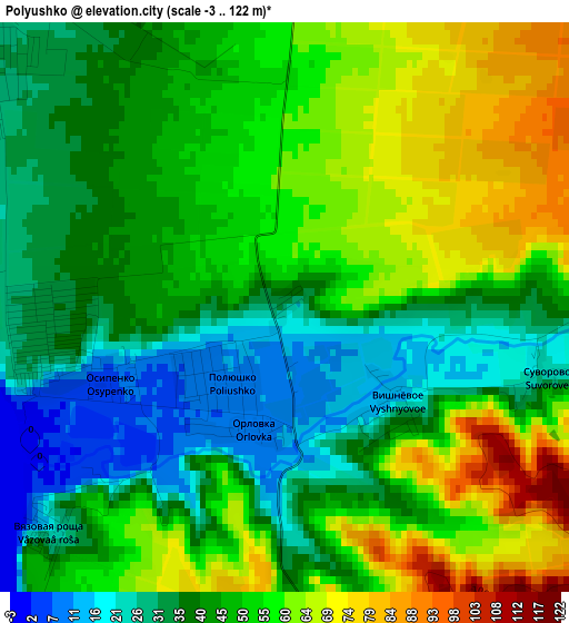
Below is the Elevation map of Polyushko, which displays elevation range with different colors. Scale of the first map is from -3 to 122 m (-10 to 400 ft) with average elevation of 47 meters (=154 ft) [note 1]
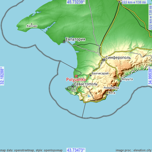
These maps also provides idea of topography and contour of this city, they are displayed at different zoom levels. More info about maps, scale and edge coordinates you can find below images.
| \ | Map #1 | Topo.Map |
| Scale [m] | -3..122 m | × |
| Scale [ft] | -10..400 ft | × |
| Average | 47 m = 154 ft | × |
| Width | 6.94 km = 4.3 mi | 222.1 km = 138 mi |
| Height | 6.94 km = 4.3 mi | 222.1 km = 138 mi |
| ↑Max Latitude | 44.773395° | 45.73239° |
| Latitude at center | 44.74219° | 44.74219° |
| ↓Min Latitude | 44.710968° | 43.73473° |
| ← Min Longitude | 33.545185° | 32.18288° |
| Longitude center | 33.58913° | 33.58913° |
| →Max Longitude | 33.633075° | 34.99538° |
Nearby cities:
Cities around Polyushko sort by population:
• Inkerman elevation 19 m
14.4 km,  173°
173°
• Vilino 34 m
13.2 km,  29°
29°
• Kacha 28 m
5.2 km,  316°
316°
• Uglovoye 36 m
8.9 km,  7°
7°
• Verkhnesadovoye 69 m
10.7 km,  123°
123°
• Kholmovka 87 m
16.1 km,  125°
125°
• Solnechniy 80 m
5.5 km,  24°
24°
• Dolinnoye 104 m
14.9 km,  85°
85°
• Andreyevka 29 m
8.5 km,  346°
346°
• Tenistoye 32 m
6.2 km, 89°
• Frontovoye 82 m
14.4 km, 125°
• Peschanoye 8 m
11.4 km, 8°
Multilingual:
 En español:
Polyushko elevación 33 m.
 En France:
Polyushko élévation 33 m.
 Auf Deutsch:
Polyushko höhe über dem Meeresspiegel ist 33 m.

Sources and notes:
- [note 1] Map square and city borders are not equal. Map elevation data is calculated only from area inside that square.
- [src 1] Elevation data from geonames database provided with same terms of usage.
- [src 2] The elevation map of Polyushko is generated using elevation data from NASA's 3 arcsec (90m) resolution SRTM data.
- [src 3] Base (background) map © OpenStreetMap contributors tiles are generated by Geofabrik and OpenTopoMap.
Copyright & License:
This Polyushko Elevation Map is licensed under CC BY-SA. You may reuse any part from this page, if you give a proper credit by linking to this URL:
 More info on terms of use page.