Chutove elevation
Chutove (Poltava), Ukraine elevation is 101 meters and Chutove elevation in feet is 331 ft above sea level [src 1]. Chutove is a seat of a second-order administrative division (feature code) with elevation that is 56 meters (184 ft) smaller than average city elevation in Ukraine.
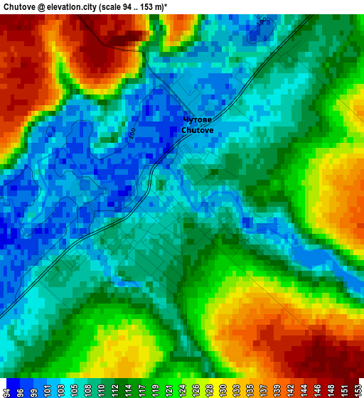
Below is the Elevation map of Chutove, which displays elevation range with different colors. Scale of the first map is from 94 to 153 m (308 to 502 ft) with average elevation of 116 meters (=381 ft) [note 1]
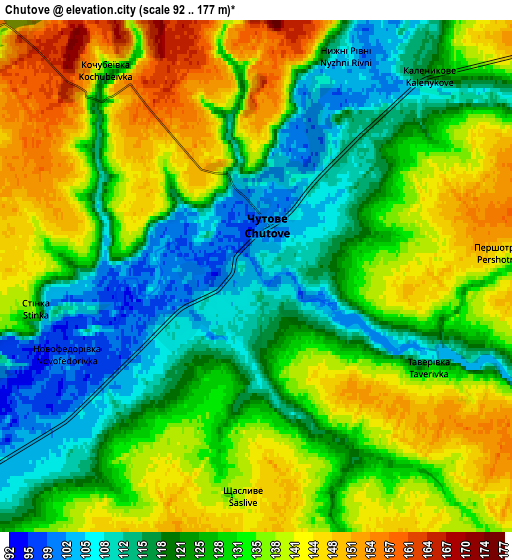
These maps also provides idea of topography and contour of this city, they are displayed at different zoom levels. More info about maps, scale and edge coordinates you can find below images.
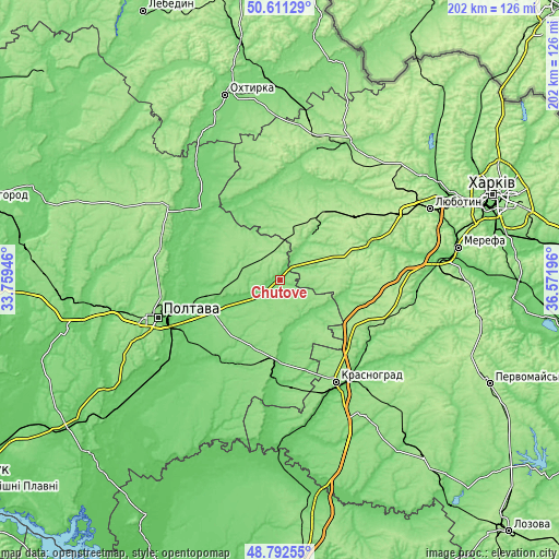
| \ | Map #1 | Map #2 | Topo.Map |
| Scale [m] | 94..153 m | 92..177 m | × |
| Scale [ft] | 308..502 ft | 302..581 ft | × |
| Average | 116 m = 381 ft | 129.3 m = 424 ft | × |
| Width | 6.32 km = 3.9 mi | 12.64 km = 7.9 mi | 202.2 km = 125.6 mi |
| Height | 6.32 km = 3.9 mi | 12.64 km = 7.9 mi | 202.2 km = 125.6 mi |
| ↑Max Latitude | 49.738839° | 49.767231° | 50.61129° |
| Latitude at center | 49.71043° | 49.71043° | 49.71043° |
| ↓Min Latitude | 49.682004° | 49.653562° | 48.79255° |
| ← Min Longitude | 35.121765° | 35.077819° | 33.75946° |
| Longitude center | 35.16571° | 35.16571° | 35.16571° |
| →Max Longitude | 35.209655° | 35.253601° | 36.57196° |
Nearby cities:
Cities around Chutove sort by population:
• Poltava elevation 159 m
46.8 km,  253°
253°
• Krasnohrad 159 m
41.8 km,  151°
151°
• Karlivka 151 m
28.3 km,  185°
185°
• Valky 138 m
35 km,  66°
66°
• Krasnokuts’k 122 m
39.5 km,  359°
359°
• Dykan’ka 168 m
47.5 km,  285°
285°
• Oposhnya 173 m
48.2 km,  304°
304°
• Mashivka 98 m
36.7 km,  215°
215°
• Kolomak 115 m
17.5 km,  34°
34°
• Verbivka 102 m
42.1 km,  140°
140°
• Huty 120 m
48.7 km,  15°
15°
• Varvarivka 105 m
19.4 km,  172°
172°
Multilingual:
 En español:
Chutove elevación 101 m.
 En France:
Chutove élévation 101 m.


Sources and notes:
- [note 1] Map square and city borders are not equal. Map elevation data is calculated only from area inside that square.
- [src 1] Elevation data from geonames database provided with same terms of usage.
- [src 2] The elevation map of Chutove is generated using elevation data from NASA's 3 arcsec (90m) resolution SRTM data.
- [src 3] Base (background) map © OpenStreetMap contributors tiles are generated by Geofabrik and OpenTopoMap.
Copyright & License:
This Chutove Elevation Map is licensed under CC BY-SA. You may reuse any part from this page, if you give a proper credit by linking to this URL:
 More info on terms of use page.