Valky elevation
Valky (Kharkiv), Ukraine elevation is 138 meters and Valky elevation in feet is 453 ft above sea level [src 1]. Valky is a seat of a second-order administrative division (feature code) with elevation that is 19 meters (62 ft) smaller than average city elevation in Ukraine.
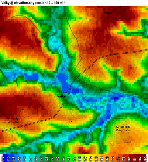
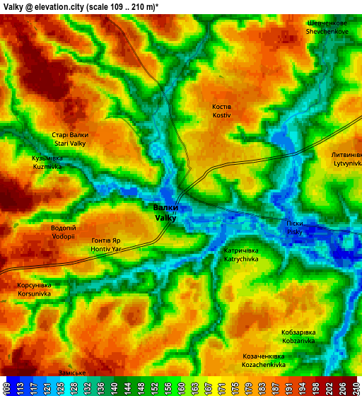
Below is the Elevation map of Valky, which displays elevation range with different colors. Scale of the first map is from 112 to 190 m (367 to 623 ft) with average elevation of 155.1 meters (=509 ft) [note 1]
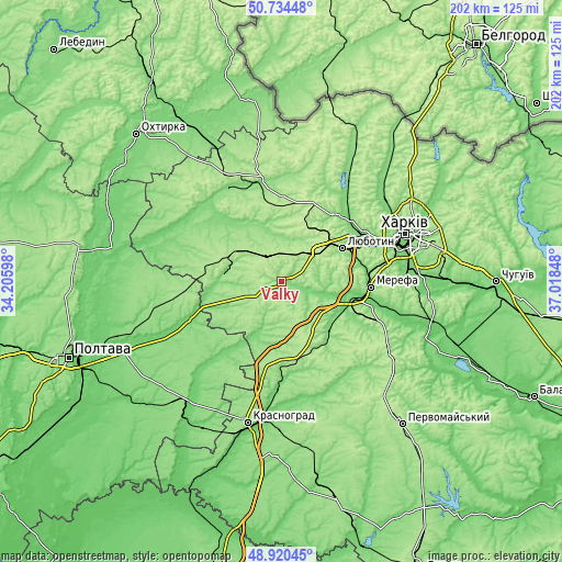
These maps also provides idea of topography and contour of this city, they are displayed at different zoom levels. More info about maps, scale and edge coordinates you can find below images.
| \ | Map #1 | Map #2 | Topo.Map |
| Scale [m] | 112..190 m | 109..210 m | × |
| Scale [ft] | 367..623 ft | 358..689 ft | × |
| Average | 155.1 m = 509 ft | 164 m = 538 ft | × |
| Width | 6.3 km = 3.9 mi | 12.61 km = 7.8 mi | 201.7 km = 125.3 mi |
| Height | 6.3 km = 3.9 mi | 12.61 km = 7.8 mi | 201.7 km = 125.3 mi |
| ↑Max Latitude | 49.864305° | 49.892624° | 50.73448° |
| Latitude at center | 49.83597° | 49.83597° | 49.83597° |
| ↓Min Latitude | 49.807618° | 49.779249° | 48.92045° |
| ← Min Longitude | 35.568285° | 35.524339° | 34.20598° |
| Longitude center | 35.61223° | 35.61223° | 35.61223° |
| →Max Longitude | 35.656175° | 35.700121° | 37.01848° |
Nearby cities:
Cities around Valky sort by population:
• Merefa elevation 102 m
31.5 km,  92°
92°
• Lyubotyn 182 m
25.8 km,  61°
61°
• Nova Vodolaha 116 m
22.4 km,  125°
125°
• Pivdenne 180 m
33.1 km,  80°
80°
• Peresichna 121 m
33.6 km,  51°
51°
• Budy 122 m
29.9 km, 78°
• Chutove 101 m
35 km,  246°
246°
• Korotych 138 m
32.9 km,  67°
67°
• Kolomak 115 m
22.1 km,  271°
271°
• Staryy Merchyk 186 m
19.3 km,  33°
33°
• Utkivka 98 m
33.7 km,  99°
99°
• Manchenky 214 m
23.8 km, 47°
Multilingual:
 En español:
Valky elevación 138 m.
 En France:
Valky élévation 138 m.


Sources and notes:
- [note 1] Map square and city borders are not equal. Map elevation data is calculated only from area inside that square.
- [src 1] Elevation data from geonames database provided with same terms of usage.
- [src 2] The elevation map of Valky is generated using elevation data from NASA's 3 arcsec (90m) resolution SRTM data.
- [src 3] Base (background) map © OpenStreetMap contributors tiles are generated by Geofabrik and OpenTopoMap.
Copyright & License:
This Valky Elevation Map is licensed under CC BY-SA. You may reuse any part from this page, if you give a proper credit by linking to this URL:
 More info on terms of use page.