Myrnohrad elevation
Myrnohrad (Donetsk, Myrnohrad Municipality), Ukraine elevation is 179 meters and Myrnohrad elevation in feet is 587 ft above sea level [src 1]. Myrnohrad is a seat of a second-order administrative division (feature code) with elevation that is 22 meters (72 ft) bigger than average city elevation in Ukraine.
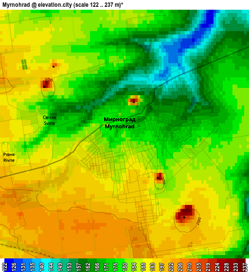
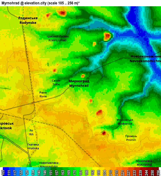
Below is the Elevation map of Myrnohrad, which displays elevation range with different colors. Scale of the first map is from 122 to 237 m (400 to 778 ft) with average elevation of 181.8 meters (=596 ft) [note 1]
These maps also provides idea of topography and contour of this city, they are displayed at different zoom levels. More info about maps, scale and edge coordinates you can find below images.
| \ | Map #1 | Map #2 | Topo.Map |
| Scale [m] | 122..237 m | 105..256 m | × |
| Scale [ft] | 400..778 ft | 344..840 ft | × |
| Average | 181.8 m = 596 ft | 180.3 m = 592 ft | × |
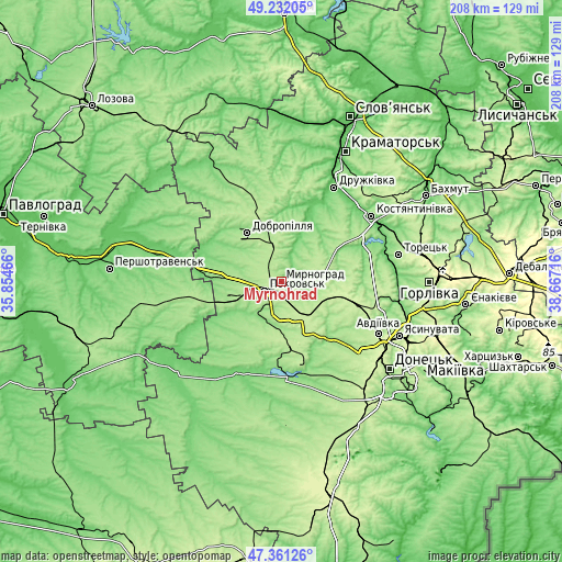
| Width | 6.5 km = 4 mi | 13 km = 8.1 mi | 208 km = 129.2 mi |
| Height | 6.5 km = 4 mi | 13 km = 8.1 mi | 208 km = 129.2 mi |
| ↑Max Latitude | 48.334452° | 48.363658° | 49.23205° |
| Latitude at center | 48.30523° | 48.30523° | 48.30523° |
| ↓Min Latitude | 48.275991° | 48.246735° | 47.36126° |
| ← Min Longitude | 37.216965° | 37.173019° | 35.85466° |
| Longitude center | 37.26091° | 37.26091° | 37.26091° |
| →Max Longitude | 37.304855° | 37.348801° | 38.66716° |
Nearby cities:
Cities around Myrnohrad sort by population:
• Kostyantynivka elevation 87 m
41.2 km,  53°
53°
• Pokrovsk 199 m
6.8 km,  247°
247°
• Druzhkivka 101 m
42 km,  30°
30°
• Dobropillya 183 m
21.7 km,  323°
323°
• Avdiyivka 212 m
40.1 km,  117°
117°
• Selydove 167 m
17.8 km,  170°
170°
• Kurakhovo 132 m
35.6 km,  177°
177°
• Rodyns’ke 192 m
6.6 km, 322°
• Bilyts’ke 193 m
12.7 km,  332°
332°
• Mezhova 181 m
39.4 km,  261°
261°
• Novodonets’ke 150 m
42 km, 330°
• Shcherbynivka 101 m
40.4 km,  75°
75°
Multilingual:
 En español:
Myrnohrad elevación 179 m.
 En France:
Myrnohrad élévation 179 m.
 Auf Deutsch:
Dymytrow höhe über dem Meeresspiegel ist 179 m.
 На русском:
Dimitrovo, Мирноград, Dimitrov высота над уровнем моря 179 м
Sources and notes:
- [note 1] Map square and city borders are not equal. Map elevation data is calculated only from area inside that square.
- [src 1] Elevation data from geonames database provided with same terms of usage.
- [src 2] The elevation map of Myrnohrad is generated using elevation data from NASA's 3 arcsec (90m) resolution SRTM data.
- [src 3] Base (background) map © OpenStreetMap contributors tiles are generated by Geofabrik and OpenTopoMap.
Copyright & License:
This Myrnohrad Elevation Map is licensed under CC BY-SA. You may reuse any part from this page, if you give a proper credit by linking to this URL:
 More info on terms of use page.