Kurakhovo elevation
Kurakhovo (Donetsk), Ukraine elevation is 132 meters and Kurakhovo elevation in feet is 433 ft above sea level [src 1]. Kurakhovo is a populated place (feature code) with elevation that is 25 meters (82 ft) smaller than average city elevation in Ukraine.
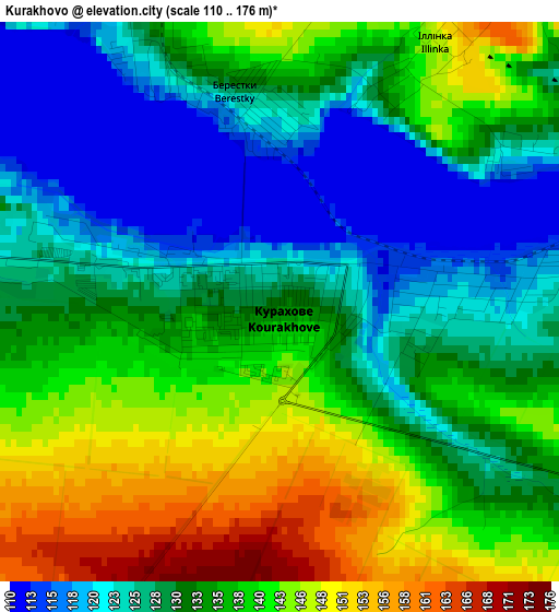
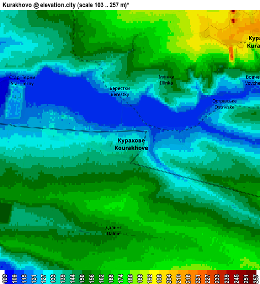
Below is the Elevation map of Kurakhovo, which displays elevation range with different colors. Scale of the first map is from 110 to 176 m (361 to 577 ft) with average elevation of 133.5 meters (=438 ft) [note 1]
These maps also provides idea of topography and contour of this city, they are displayed at different zoom levels. More info about maps, scale and edge coordinates you can find below images.
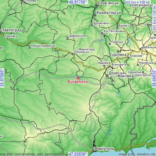
| \ | Map #1 | Map #2 | Topo.Map |
| Scale [m] | 110..176 m | 103..257 m | × |
| Scale [ft] | 361..577 ft | 338..843 ft | × |
| Average | 133.5 m = 438 ft | 147.6 m = 484 ft | × |
| Width | 6.54 km = 4.1 mi | 13.08 km = 8.1 mi | 209.3 km = 130.1 mi |
| Height | 6.54 km = 4.1 mi | 13.08 km = 8.1 mi | 209.3 km = 130.1 mi |
| ↑Max Latitude | 48.014625° | 48.044014° | 48.91788° |
| Latitude at center | 47.98522° | 47.98522° | 47.98522° |
| ↓Min Latitude | 47.955798° | 47.926359° | 47.03539° |
| ← Min Longitude | 37.238155° | 37.194209° | 35.87585° |
| Longitude center | 37.2821° | 37.2821° | 37.2821° |
| →Max Longitude | 37.326045° | 37.369991° | 38.68835° |
Nearby cities:
Cities around Kurakhovo sort by population:
• Donetsk elevation 223 m
38.9 km,  83°
83°
• Pokrovsk 199 m
33.9 km,  346°
346°
• Myrnohrad 179 m
35.6 km,  357°
357°
• Yasynuvata 263 m
45.8 km,  69°
69°
• Avdiyivka 212 m
38.3 km,  63°
63°
• Selydove 167 m
18 km,  4°
4°
• Dokuchayevs’k 158 m
39.5 km,  131°
131°
• Volnovakha 260 m
45.6 km,  159°
159°
• Rodyns’ke 192 m
41.2 km, 352°
• Mar'yinka 139 m
17.2 km,  104°
104°
• Blahodatne 212 m
33.3 km, 162°
• Velyka Novosilka 106 m
36.7 km,  244°
244°
Multilingual:
 En español:
Kurakhovo elevación 132 m.
 En France:
Kurakhovo élévation 132 m.
 Auf Deutsch:
Kurakhovo höhe über dem Meeresspiegel ist 132 m.

Sources and notes:
- [note 1] Map square and city borders are not equal. Map elevation data is calculated only from area inside that square.
- [src 1] Elevation data from geonames database provided with same terms of usage.
- [src 2] The elevation map of Kurakhovo is generated using elevation data from NASA's 3 arcsec (90m) resolution SRTM data.
- [src 3] Base (background) map © OpenStreetMap contributors tiles are generated by Geofabrik and OpenTopoMap.
Copyright & License:
This Kurakhovo Elevation Map is licensed under CC BY-SA. You may reuse any part from this page, if you give a proper credit by linking to this URL:
 More info on terms of use page.