Ivanivka elevation
Ivanivka (Odesa, Ivanivs’kyy Rayon), Ukraine elevation is 19 meters and Ivanivka elevation in feet is 62 ft above sea level [src 1]. Ivanivka is a seat of a second-order administrative division (feature code) with elevation that is 138 meters (453 ft) smaller than average city elevation in Ukraine.
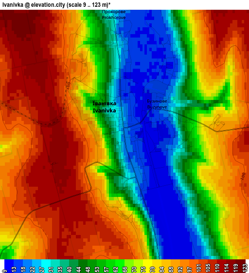
Below is the Elevation map of Ivanivka, which displays elevation range with different colors. Scale of the first map is from 9 to 123 m (30 to 404 ft) with average elevation of 72 meters (=236 ft) [note 1]
These maps also provides idea of topography and contour of this city, they are displayed at different zoom levels. More info about maps, scale and edge coordinates you can find below images.
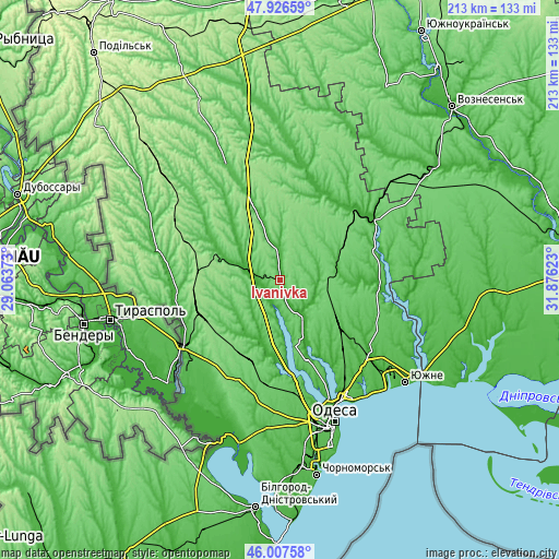
| \ | Map #1 | Topo.Map |
| Scale [m] | 9..123 m | × |
| Scale [ft] | 30..404 ft | × |
| Average | 72 m = 236 ft | × |
| Width | 6.67 km = 4.1 mi | 213.4 km = 132.6 mi |
| Height | 6.67 km = 4.1 mi | 213.4 km = 132.6 mi |
| ↑Max Latitude | 47.005666° | 47.92659° |
| Latitude at center | 46.97569° | 46.97569° |
| ↓Min Latitude | 46.945697° | 46.00758° |
| ← Min Longitude | 30.426035° | 29.06373° |
| Longitude center | 30.46998° | 30.46998° |
| →Max Longitude | 30.513925° | 31.87623° |
Nearby cities:
Cities around Ivanivka sort by population:
• Rozdil’na elevation 146 m
33.1 km,  243°
243°
• Berezivka 14 m
41.8 km,  52°
52°
• Lymanske 11 m
52.2 km,  227°
227°
• Usatove 25 m
51.3 km,  163°
163°
• Shyryayeve 54 m
49.5 km,  335°
335°
• Velyka Mykhaylivka 48 m
47.8 km,  283°
283°
• Kurisove 9 m
37.1 km,  91°
91°
• Krasnosilka 38 m
45.6 km,  149°
149°
• Kremidivka 75 m
36 km,  138°
138°
• Stepanivka 10 m
41.9 km, 241°
• Stepove 53 m
42.4 km,  224°
224°
• Dobroslav 49 m
40 km,  116°
116°
Multilingual:
 En español:
Ivanivka elevación 19 m.
 En France:
Ivanivka élévation 19 m.


Sources and notes:
- [note 1] Map square and city borders are not equal. Map elevation data is calculated only from area inside that square.
- [src 1] Elevation data from geonames database provided with same terms of usage.
- [src 2] The elevation map of Ivanivka is generated using elevation data from NASA's 3 arcsec (90m) resolution SRTM data.
- [src 3] Base (background) map © OpenStreetMap contributors tiles are generated by Geofabrik and OpenTopoMap.
Copyright & License:
This Ivanivka Elevation Map is licensed under CC BY-SA. You may reuse any part from this page, if you give a proper credit by linking to this URL:
 More info on terms of use page.