Izyum elevation
Izyum (Kharkiv), Ukraine elevation is 79 meters and Izyum elevation in feet is 259 ft above sea level [src 1]. Izyum is a seat of a second-order administrative division (feature code) with elevation that is 78 meters (256 ft) smaller than average city elevation in Ukraine.
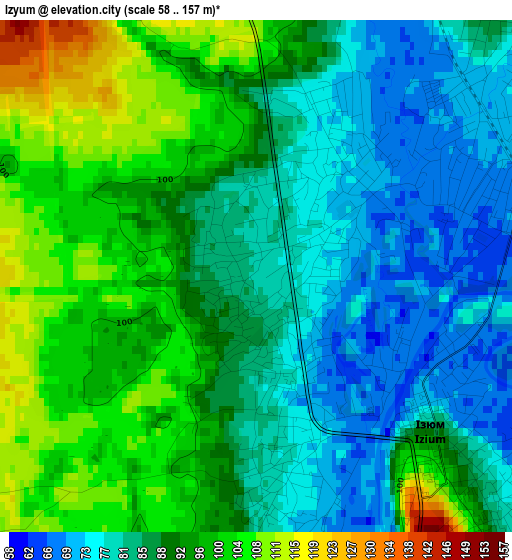
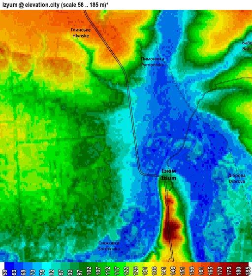
Below is the Elevation map of Izyum, which displays elevation range with different colors. Scale of the first map is from 58 to 157 m (190 to 515 ft) with average elevation of 89.4 meters (=293 ft) [note 1]
These maps also provides idea of topography and contour of this city, they are displayed at different zoom levels. More info about maps, scale and edge coordinates you can find below images.
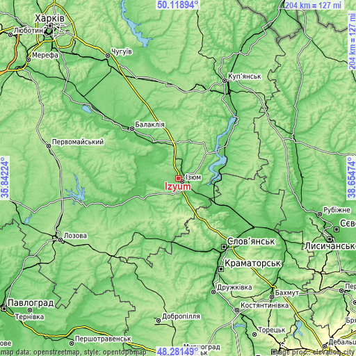
| \ | Map #1 | Map #2 | Topo.Map |
| Scale [m] | 58..157 m | 58..185 m | × |
| Scale [ft] | 190..515 ft | 190..607 ft | × |
| Average | 89.4 m = 293 ft | 102.1 m = 335 ft | × |
| Width | 6.38 km = 4 mi | 12.77 km = 7.9 mi | 204.3 km = 126.9 mi |
| Height | 6.38 km = 4 mi | 12.77 km = 7.9 mi | 204.3 km = 126.9 mi |
| ↑Max Latitude | 49.237451° | 49.266136° | 50.11894° |
| Latitude at center | 49.20875° | 49.20875° | 49.20875° |
| ↓Min Latitude | 49.180032° | 49.151297° | 48.28149° |
| ← Min Longitude | 37.204545° | 37.160599° | 35.84224° |
| Longitude center | 37.24849° | 37.24849° | 37.24849° |
| →Max Longitude | 37.292435° | 37.336381° | 38.65474° |
Nearby cities:
Cities around Izyum sort by population:
• Sloviansk elevation 61 m
46.6 km,  144°
144°
• Balakliya 79 m
39.9 km,  315°
315°
• Barvinkove 92 m
37.2 km,  206°
206°
• Borova 88 m
32.9 km,  55°
55°
• Savyntsi 101 m
25.4 km,  327°
327°
• Svyatogorsk 66 m
30.3 km,  130°
130°
• Petrivs’ke 97 m
25.6 km,  262°
262°
• Chervonyy Oskil 81 m
13.3 km,  104°
104°
• Studenok 72 m
21.7 km, 127°
• Drobysheve 100 m
39.6 km,  117°
117°
• Novoselivka 103 m
36 km, 115°
• Yats’kivka 85 m
20.3 km, 99°
Multilingual:
 En español:
Izyum elevación 79 m.
 En France:
Izyum élévation 79 m.


Sources and notes:
- [note 1] Map square and city borders are not equal. Map elevation data is calculated only from area inside that square.
- [src 1] Elevation data from geonames database provided with same terms of usage.
- [src 2] The elevation map of Izyum is generated using elevation data from NASA's 3 arcsec (90m) resolution SRTM data.
- [src 3] Base (background) map © OpenStreetMap contributors tiles are generated by Geofabrik and OpenTopoMap.
Copyright & License:
This Izyum Elevation Map is licensed under CC BY-SA. You may reuse any part from this page, if you give a proper credit by linking to this URL:
 More info on terms of use page.