Savyntsi elevation
Savyntsi (Kharkiv), Ukraine elevation is 101 meters and Savyntsi elevation in feet is 331 ft above sea level [src 1]. Savyntsi is a populated place (feature code) with elevation that is 56 meters (184 ft) smaller than average city elevation in Ukraine.
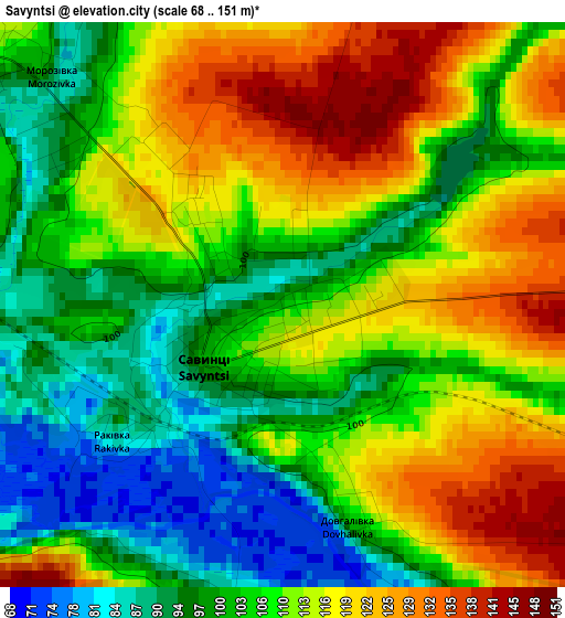
Below is the Elevation map of Savyntsi, which displays elevation range with different colors. Scale of the first map is from 68 to 151 m (223 to 495 ft) with average elevation of 108.3 meters (=355 ft) [note 1]
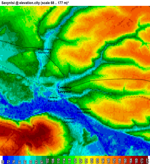
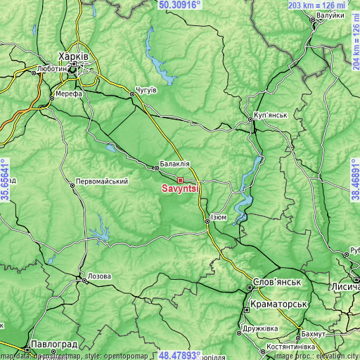
These maps also provides idea of topography and contour of this city, they are displayed at different zoom levels. More info about maps, scale and edge coordinates you can find below images.
| \ | Map #1 | Map #2 | Topo.Map |
| Scale [m] | 68..151 m | 68..177 m | × |
| Scale [ft] | 223..495 ft | 223..581 ft | × |
| Average | 108.3 m = 355 ft | 117.4 m = 385 ft | × |
| Width | 6.36 km = 4 mi | 12.72 km = 7.9 mi | 203.5 km = 126.4 mi |
| Height | 6.36 km = 4 mi | 12.72 km = 7.9 mi | 203.5 km = 126.4 mi |
| ↑Max Latitude | 49.431159° | 49.459731° | 50.30916° |
| Latitude at center | 49.40257° | 49.40257° | 49.40257° |
| ↓Min Latitude | 49.373965° | 49.345343° | 48.47893° |
| ← Min Longitude | 37.018715° | 36.974769° | 35.65641° |
| Longitude center | 37.06266° | 37.06266° | 37.06266° |
| →Max Longitude | 37.106605° | 37.150551° | 38.46891° |
Nearby cities:
Cities around Savyntsi sort by population:
• Izyum elevation 79 m
25.4 km,  147°
147°
• Balakliya 79 m
16.1 km,  294°
294°
• Kivsharivka 95 m
51.8 km,  60°
60°
• Slobozhans’ke 99 m
44.4 km,  299°
299°
• Malynivka 100 m
51.8 km,  332°
332°
• Shevchenkove 171 m
33.6 km,  13°
13°
• Borova 88 m
40.5 km,  93°
93°
• Lyman 94 m
48 km, 296°
• Petrivs’ke 97 m
27.7 km,  205°
205°
• Chervonyy Oskil 81 m
36.2 km,  133°
133°
• Studenok 72 m
46.3 km,  138°
138°
• Yats’kivka 85 m
41.6 km, 126°
Multilingual:
 En español:
Savyntsi elevación 101 m.
 En France:
Savyntsi élévation 101 m.
 Auf Deutsch:
Savyntsi höhe über dem Meeresspiegel ist 101 m.

Sources and notes:
- [note 1] Map square and city borders are not equal. Map elevation data is calculated only from area inside that square.
- [src 1] Elevation data from geonames database provided with same terms of usage.
- [src 2] The elevation map of Savyntsi is generated using elevation data from NASA's 3 arcsec (90m) resolution SRTM data.
- [src 3] Base (background) map © OpenStreetMap contributors tiles are generated by Geofabrik and OpenTopoMap.
Copyright & License:
This Savyntsi Elevation Map is licensed under CC BY-SA. You may reuse any part from this page, if you give a proper credit by linking to this URL:
 More info on terms of use page.