Drobysheve elevation
Drobysheve (Donetsk, Lyman Amalgated Territorial Community), Ukraine elevation is 100 meters and Drobysheve elevation in feet is 328 ft above sea level [src 1]. Drobysheve is a seat of a third-order administrative division (feature code) with elevation that is 57 meters (187 ft) smaller than average city elevation in Ukraine.
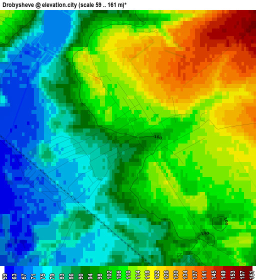
Below is the Elevation map of Drobysheve, which displays elevation range with different colors. Scale of the first map is from 59 to 161 m (194 to 528 ft) with average elevation of 98.9 meters (=324 ft) [note 1]
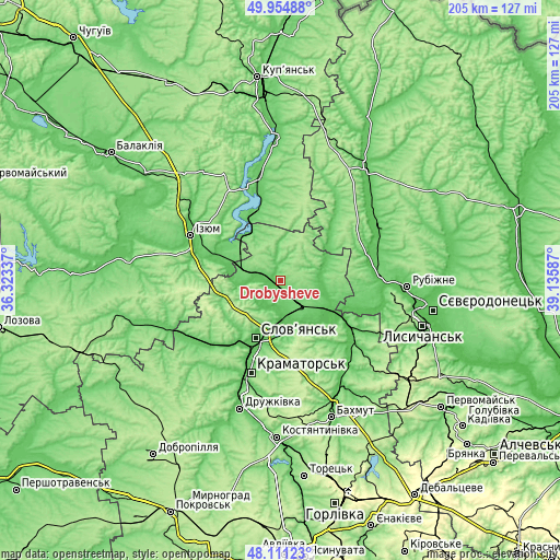
These maps also provides idea of topography and contour of this city, they are displayed at different zoom levels. More info about maps, scale and edge coordinates you can find below images.
| \ | Map #1 | Topo.Map |
| Scale [m] | 59..161 m | × |
| Scale [ft] | 194..528 ft | × |
| Average | 98.9 m = 324 ft | × |
| Width | 6.41 km = 4 mi | 205 km = 127.4 mi |
| Height | 6.41 km = 4 mi | 205 km = 127.4 mi |
| ↑Max Latitude | 49.070398° | 49.95488° |
| Latitude at center | 49.0416° | 49.0416° |
| ↓Min Latitude | 49.012785° | 48.11123° |
| ← Min Longitude | 37.685675° | 36.32337° |
| Longitude center | 37.72962° | 37.72962° |
| →Max Longitude | 37.773565° | 39.13587° |
Nearby cities:
Cities around Drobysheve sort by population:
• Sloviansk elevation 61 m
21.1 km,  202°
202°
• Lyman 101 m
7.9 km,  138°
138°
• Svyatogorsk 66 m
11.9 km,  265°
265°
• Chervonyy Oskil 81 m
26.9 km,  304°
304°
• Studenok 72 m
18.5 km,  287°
287°
• Serebryanka 77 m
32.6 km,  114°
114°
• Kryva Luka 67 m
22.6 km,  145°
145°
• Yats’kivka 85 m
21.5 km,  315°
315°
• Yampil’ 57 m
20.3 km,  125°
125°
• Terny 76 m
17.8 km,  71°
71°
• Zarichne 71 m
14.9 km,  97°
97°
• Novoselivka 103 m
4 km, 321°
Multilingual:
 En español:
Drobysheve elevación 100 m.
 En France:
Drobysheve élévation 100 m.
 Auf Deutsch:
Drobysheve höhe über dem Meeresspiegel ist 100 m.
 На русском:
Drobyshevo, Дробышево высота над уровнем моря 100 м
Sources and notes:
- [note 1] Map square and city borders are not equal. Map elevation data is calculated only from area inside that square.
- [src 1] Elevation data from geonames database provided with same terms of usage.
- [src 2] The elevation map of Drobysheve is generated using elevation data from NASA's 3 arcsec (90m) resolution SRTM data.
- [src 3] Base (background) map © OpenStreetMap contributors tiles are generated by Geofabrik and OpenTopoMap.
Copyright & License:
This Drobysheve Elevation Map is licensed under CC BY-SA. You may reuse any part from this page, if you give a proper credit by linking to this URL:
 More info on terms of use page.