Khmilnyk elevation
Khmilnyk (Vinnyts'ka), Ukraine elevation is 266 meters and Khmilnyk elevation in feet is 873 ft above sea level [src 1]. Khmilnyk is a populated place (feature code) with elevation that is 109 meters (358 ft) bigger than average city elevation in Ukraine.
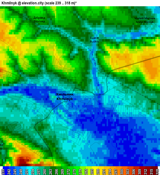
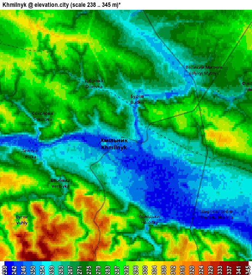
Below is the Elevation map of Khmilnyk, which displays elevation range with different colors. Scale of the first map is from 239 to 318 m (784 to 1043 ft) with average elevation of 262.6 meters (=862 ft) [note 1]
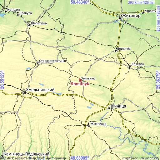
These maps also provides idea of topography and contour of this city, they are displayed at different zoom levels. More info about maps, scale and edge coordinates you can find below images.
| \ | Map #1 | Map #2 | Topo.Map |
| Scale [m] | 239..318 m | 238..345 m | × |
| Scale [ft] | 784..1043 ft | 781..1132 ft | × |
| Average | 262.6 m = 862 ft | 275.8 m = 905 ft | × |
| Width | 6.34 km = 3.9 mi | 12.68 km = 7.9 mi | 202.9 km = 126.1 mi |
| Height | 6.34 km = 3.9 mi | 12.68 km = 7.9 mi | 202.8 km = 126 mi |
| ↑Max Latitude | 49.588287° | 49.616767° | 50.46346° |
| Latitude at center | 49.55979° | 49.55979° | 49.55979° |
| ↓Min Latitude | 49.531276° | 49.502746° | 48.63909° |
| ← Min Longitude | 27.913595° | 27.869649° | 26.55129° |
| Longitude center | 27.95754° | 27.95754° | 27.95754° |
| →Max Longitude | 28.001485° | 28.045431° | 29.36379° |
Nearby cities:
Cities around Khmilnyk sort by population:
• Vinnytsia elevation 235 m
52.5 km,  133°
133°
• Kalynivka 280 m
42.7 km,  106°
106°
• Letychiv 278 m
30.8 km,  230°
230°
• Derazhnya 281 m
49.8 km, 229°
• Lityn 268 m
27.6 km,  161°
161°
• Chudniv 246 m
55.9 km,  11°
11°
• Stara Syniava 292 m
24.9 km,  281°
281°
• Brailiv 260 m
52.4 km, 162°
• Pavlivka 261 m
38.6 km, 109°
• Ulaniv 269 m
19.6 km,  40°
40°
• Liubar 236 m
42.6 km,  340°
340°
• Medzhybizh 293 m
42.2 km,  251°
251°
Multilingual:
 En español:
Khmilnyk elevación 266 m.
 En France:
Khmilnyk élévation 266 m.
 Auf Deutsch:
Khmilnyk höhe über dem Meeresspiegel ist 266 m.

Sources and notes:
- [note 1] Map square and city borders are not equal. Map elevation data is calculated only from area inside that square.
- [src 1] Elevation data from geonames database provided with same terms of usage.
- [src 2] The elevation map of Khmilnyk is generated using elevation data from NASA's 3 arcsec (90m) resolution SRTM data.
- [src 3] Base (background) map © OpenStreetMap contributors tiles are generated by Geofabrik and OpenTopoMap.
Copyright & License:
This Khmilnyk Elevation Map is licensed under CC BY-SA. You may reuse any part from this page, if you give a proper credit by linking to this URL:
 More info on terms of use page.