Liubar elevation
Liubar (Zhytomyr), Ukraine elevation is 236 meters and Liubar elevation in feet is 774 ft above sea level [src 1]. Liubar is a seat of a second-order administrative division (feature code) with elevation that is 79 meters (259 ft) bigger than average city elevation in Ukraine.
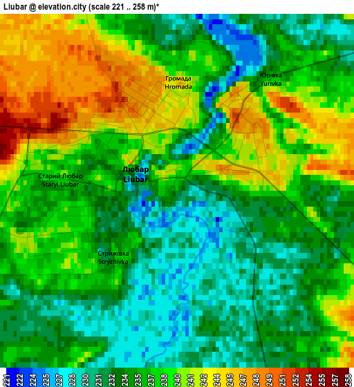
Below is the Elevation map of Liubar, which displays elevation range with different colors. Scale of the first map is from 221 to 258 m (725 to 846 ft) with average elevation of 236.4 meters (=776 ft) [note 1]
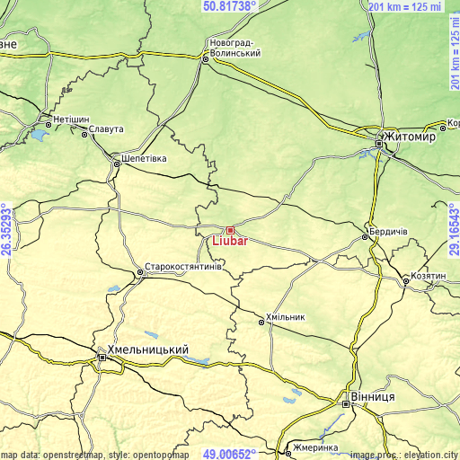
These maps also provides idea of topography and contour of this city, they are displayed at different zoom levels. More info about maps, scale and edge coordinates you can find below images.
| \ | Map #1 | Topo.Map |
| Scale [m] | 221..258 m | × |
| Scale [ft] | 725..846 ft | × |
| Average | 236.4 m = 776 ft | × |
| Width | 6.29 km = 3.9 mi | 201.3 km = 125.1 mi |
| Height | 6.29 km = 3.9 mi | 201.3 km = 125.1 mi |
| ↑Max Latitude | 49.948736° | 50.81738° |
| Latitude at center | 49.92045° | 49.92045° |
| ↓Min Latitude | 49.892147° | 49.00652° |
| ← Min Longitude | 27.715235° | 26.35293° |
| Longitude center | 27.75918° | 27.75918° |
| →Max Longitude | 27.803125° | 29.16543° |
Nearby cities:
Cities around Liubar sort by population:
• Starokostiantyniv elevation 268 m
43.8 km,  245°
245°
• Khmilnyk 266 m
42.6 km,  160°
160°
• Polonne 233 m
28.8 km,  321°
321°
• Baranivka 223 m
42.4 km,  350°
350°
• Poninka 239 m
33.4 km,  331°
331°
• Chudniv 246 m
29.5 km,  60°
60°
• Stara Syniava 292 m
36.7 km,  195°
195°
• Novoselytsya 239 m
23.9 km,  314°
314°
• Ulaniv 269 m
36.7 km,  133°
133°
• Bykivka 250 m
44.4 km,  21°
21°
• Polyanka 217 m
37.9 km, 352°
• Romaniv 239 m
28.1 km,  25°
25°
Multilingual:
 En español:
Liubar elevación 236 m.
 En France:
Liubar élévation 236 m.


Sources and notes:
- [note 1] Map square and city borders are not equal. Map elevation data is calculated only from area inside that square.
- [src 1] Elevation data from geonames database provided with same terms of usage.
- [src 2] The elevation map of Liubar is generated using elevation data from NASA's 3 arcsec (90m) resolution SRTM data.
- [src 3] Base (background) map © OpenStreetMap contributors tiles are generated by Geofabrik and OpenTopoMap.
Copyright & License:
This Liubar Elevation Map is licensed under CC BY-SA. You may reuse any part from this page, if you give a proper credit by linking to this URL:
 More info on terms of use page.