Novoselytsya elevation
Novoselytsya (Khmelnytskyi), Ukraine elevation is 239 meters and Novoselytsya elevation in feet is 784 ft above sea level [src 1]. Novoselytsya is a populated place (feature code) with elevation that is 82 meters (269 ft) bigger than average city elevation in Ukraine.
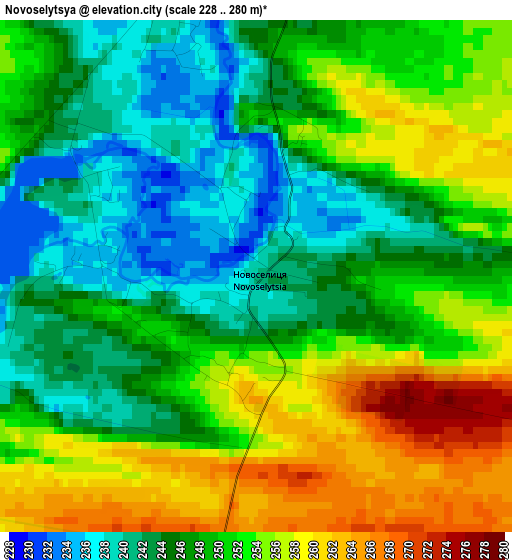
Below is the Elevation map of Novoselytsya, which displays elevation range with different colors. Scale of the first map is from 228 to 280 m (748 to 919 ft) with average elevation of 249.3 meters (=818 ft) [note 1]
These maps also provides idea of topography and contour of this city, they are displayed at different zoom levels. More info about maps, scale and edge coordinates you can find below images.
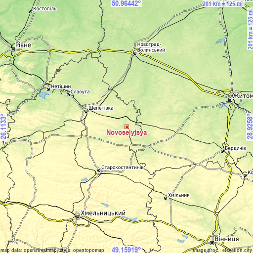
| \ | Map #1 | Topo.Map |
| Scale [m] | 228..280 m | × |
| Scale [ft] | 748..919 ft | × |
| Average | 249.3 m = 818 ft | × |
| Width | 6.27 km = 3.9 mi | 200.7 km = 124.7 mi |
| Height | 6.27 km = 3.9 mi | 200.7 km = 124.7 mi |
| ↑Max Latitude | 50.098498° | 50.96442° |
| Latitude at center | 50.0703° | 50.0703° |
| ↓Min Latitude | 50.042086° | 49.15919° |
| ← Min Longitude | 27.475605° | 26.1133° |
| Longitude center | 27.51955° | 27.51955° |
| →Max Longitude | 27.563495° | 28.9258° |
Nearby cities:
Cities around Novoselytsya sort by population:
• Shepetivka elevation 252 m
34.9 km,  291°
291°
• Starokostiantyniv 268 m
41.5 km,  213°
213°
• Polonne 233 m
6 km,  354°
354°
• Izyaslav 231 m
50.1 km,  276°
276°
• Baranivka 223 m
27.2 km,  21°
21°
• Poninka 239 m
12.8 km,  5°
5°
• Chudniv 246 m
42.7 km,  92°
92°
• Dovbysh 241 m
47.4 km,  44°
44°
• Liubar 236 m
23.9 km,  134°
134°
• Bykivka 250 m
41.3 km,  53°
53°
• Polyanka 217 m
24.1 km,  29°
29°
• Romaniv 239 m
30.6 km,  73°
73°
Multilingual:
 En español:
Novoselytsya elevación 239 m.
 En France:
Novoselytsya élévation 239 m.
 Auf Deutsch:
Novoselytsya höhe über dem Meeresspiegel ist 239 m.

Sources and notes:
- [note 1] Map square and city borders are not equal. Map elevation data is calculated only from area inside that square.
- [src 1] Elevation data from geonames database provided with same terms of usage.
- [src 2] The elevation map of Novoselytsya is generated using elevation data from NASA's 3 arcsec (90m) resolution SRTM data.
- [src 3] Base (background) map © OpenStreetMap contributors tiles are generated by Geofabrik and OpenTopoMap.
Copyright & License:
This Novoselytsya Elevation Map is licensed under CC BY-SA. You may reuse any part from this page, if you give a proper credit by linking to this URL:
 More info on terms of use page.