Kolomyia elevation
Kolomyia (Ivano-Frankivsk, Kolomyys’kyy Rayon), Ukraine elevation is 289 meters and Kolomyia elevation in feet is 948 ft above sea level [src 1]. Kolomyia is a seat of a second-order administrative division (feature code) with elevation that is 132 meters (433 ft) bigger than average city elevation in Ukraine.
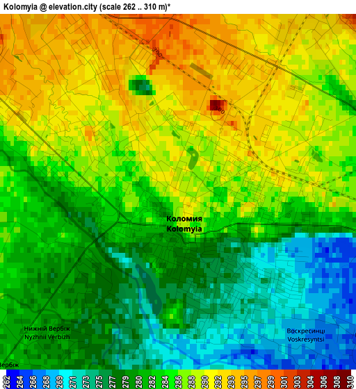
Below is the Elevation map of Kolomyia, which displays elevation range with different colors. Scale of the first map is from 262 to 310 m (860 to 1017 ft) with average elevation of 284 meters (=932 ft) [note 1]
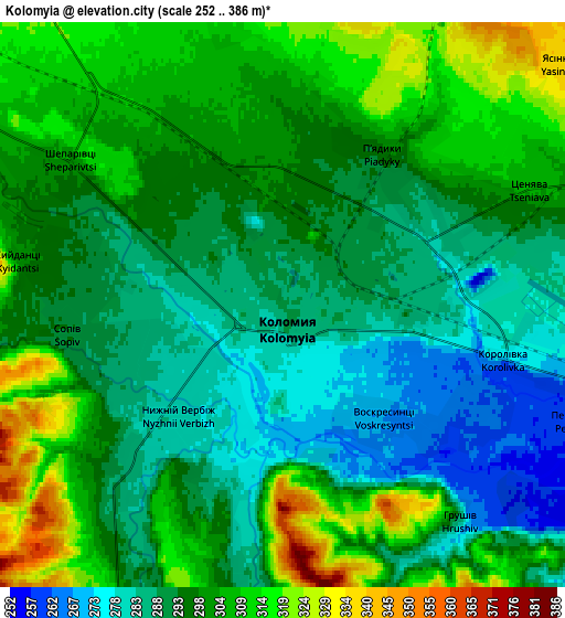
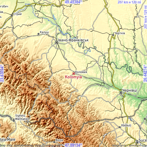
These maps also provides idea of topography and contour of this city, they are displayed at different zoom levels. More info about maps, scale and edge coordinates you can find below images.
| \ | Map #1 | Map #2 | Topo.Map |
| Scale [m] | 262..310 m | 252..386 m | × |
| Scale [ft] | 860..1017 ft | 827..1266 ft | × |
| Average | 284 m = 932 ft | 297.2 m = 975 ft | × |
| Width | 6.47 km = 4 mi | 12.94 km = 8 mi | 207.1 km = 128.7 mi |
| Height | 6.47 km = 4 mi | 12.94 km = 8 mi | 207.1 km = 128.7 mi |
| ↑Max Latitude | 48.560243° | 48.589319° | 49.45384° |
| Latitude at center | 48.53115° | 48.53115° | 48.53115° |
| ↓Min Latitude | 48.50204° | 48.472914° | 47.59134° |
| ← Min Longitude | 24.992545° | 24.948599° | 23.63024° |
| Longitude center | 25.03649° | 25.03649° | 25.03649° |
| →Max Longitude | 25.080435° | 25.124381° | 26.44274° |
Nearby cities:
Cities around Kolomyia sort by population:
• Kosiv elevation 369 m
24.9 km,  169°
169°
• Lanchyn 379 m
20.8 km,  278°
278°
• Rozhniv 282 m
23.1 km,  142°
142°
• Pechenizhyn 333 m
10.6 km,  260°
260°
• Bili Oslavy 486 m
25.2 km, 258°
• Zabolotiv 233 m
19.6 km,  110°
110°
• Velykyy Klyuchiv 378 m
9.4 km,  224°
224°
• Sadzhavka 364 m
18.7 km, 281°
• Obertyn 294 m
21.2 km,  27°
27°
• Khymchyn 363 m
18.1 km,  152°
152°
• Sheshory 432 m
22.5 km,  190°
190°
• Yabluniv 351 m
15.9 km,  207°
207°
Multilingual:
 En español:
Kolomyia elevación 289 m.
 En France:
Kolomyia élévation 289 m.
 Auf Deutsch:
Kolomea, Kolomyja höhe über dem Meeresspiegel ist 289 m.

Sources and notes:
- [note 1] Map square and city borders are not equal. Map elevation data is calculated only from area inside that square.
- [src 1] Elevation data from geonames database provided with same terms of usage.
- [src 2] The elevation map of Kolomyia is generated using elevation data from NASA's 3 arcsec (90m) resolution SRTM data.
- [src 3] Base (background) map © OpenStreetMap contributors tiles are generated by Geofabrik and OpenTopoMap.
Copyright & License:
This Kolomyia Elevation Map is licensed under CC BY-SA. You may reuse any part from this page, if you give a proper credit by linking to this URL:
 More info on terms of use page.