Rozhniv elevation
Rozhniv (Ivano-Frankivsk), Ukraine elevation is 282 meters and Rozhniv elevation in feet is 925 ft above sea level [src 1]. Rozhniv is a populated place (feature code) with elevation that is 125 meters (410 ft) bigger than average city elevation in Ukraine.
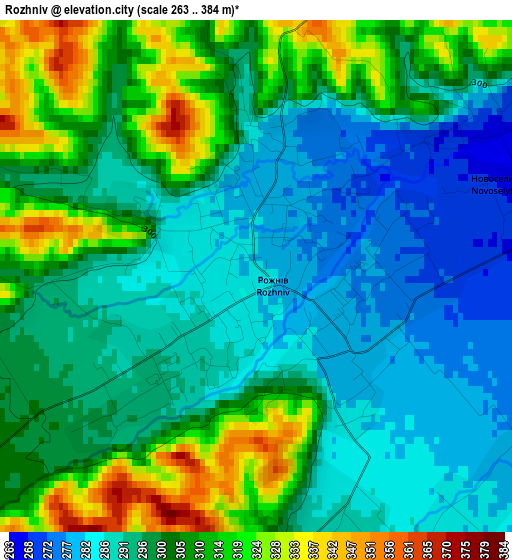
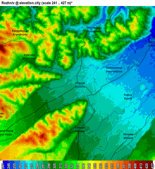
Below is the Elevation map of Rozhniv, which displays elevation range with different colors. Scale of the first map is from 263 to 384 m (863 to 1260 ft) with average elevation of 299.2 meters (=982 ft) [note 1]
These maps also provides idea of topography and contour of this city, they are displayed at different zoom levels. More info about maps, scale and edge coordinates you can find below images.
| \ | Map #1 | Map #2 | Topo.Map |
| Scale [m] | 263..384 m | 241..427 m | × |
| Scale [ft] | 863..1260 ft | 791..1401 ft | × |
| Average | 299.2 m = 982 ft | 308.5 m = 1012 ft | × |
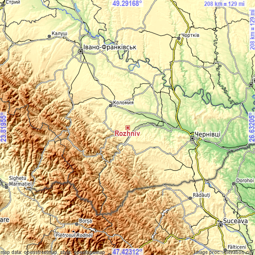
| Width | 6.49 km = 4 mi | 12.99 km = 8.1 mi | 207.8 km = 129.1 mi |
| Height | 6.49 km = 4 mi | 12.99 km = 8.1 mi | 207.8 km = 129.1 mi |
| ↑Max Latitude | 48.395158° | 48.424328° | 49.29168° |
| Latitude at center | 48.36597° | 48.36597° | 48.36597° |
| ↓Min Latitude | 48.336766° | 48.307545° | 47.42312° |
| ← Min Longitude | 25.181855° | 25.137909° | 23.81955° |
| Longitude center | 25.2258° | 25.2258° | 25.2258° |
| →Max Longitude | 25.269745° | 25.313691° | 26.63205° |
Nearby cities:
Cities around Rozhniv sort by population:
• Berehomet elevation 450 m
22.7 km,  156°
156°
• Kosiv 369 m
11.4 km,  237°
237°
• Vashkivtsi 211 m
21.1 km,  84°
84°
• Stari Kuty 347 m
11.3 km,  200°
200°
• Vyzhnytsya 338 m
13.3 km,  190°
190°
• Ispas 323 m
8.4 km,  154°
154°
• Kuty 328 m
12.4 km, 196°
• Zabolotiv 233 m
12.4 km,  20°
20°
• Banyliv 253 m
8.8 km,  89°
89°
• Khymchyn 363 m
6.2 km,  291°
291°
• Sheshory 432 m
18.3 km,  258°
258°
• Yabluniv 351 m
21.6 km,  281°
281°
Multilingual:
 En español:
Rozhniv elevación 282 m.
 En France:
Rozhniv élévation 282 m.


Sources and notes:
- [note 1] Map square and city borders are not equal. Map elevation data is calculated only from area inside that square.
- [src 1] Elevation data from geonames database provided with same terms of usage.
- [src 2] The elevation map of Rozhniv is generated using elevation data from NASA's 3 arcsec (90m) resolution SRTM data.
- [src 3] Base (background) map © OpenStreetMap contributors tiles are generated by Geofabrik and OpenTopoMap.
Copyright & License:
This Rozhniv Elevation Map is licensed under CC BY-SA. You may reuse any part from this page, if you give a proper credit by linking to this URL:
 More info on terms of use page.