Obertyn elevation
Obertyn (Ivano-Frankivsk), Ukraine elevation is 294 meters and Obertyn elevation in feet is 965 ft above sea level [src 1]. Obertyn is a populated place (feature code) with elevation that is 137 meters (449 ft) bigger than average city elevation in Ukraine.
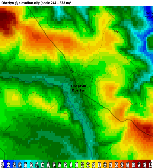
Below is the Elevation map of Obertyn, which displays elevation range with different colors. Scale of the first map is from 244 to 373 m (801 to 1224 ft) with average elevation of 303.6 meters (=996 ft) [note 1]
These maps also provides idea of topography and contour of this city, they are displayed at different zoom levels. More info about maps, scale and edge coordinates you can find below images.
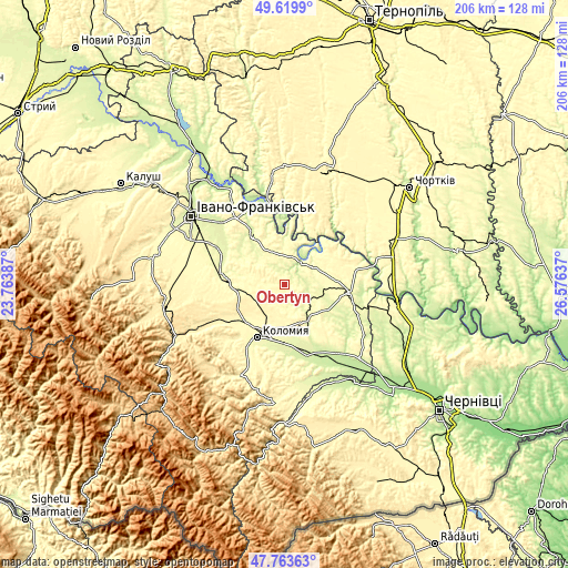
| \ | Map #1 | Topo.Map |
| Scale [m] | 244..373 m | × |
| Scale [ft] | 801..1224 ft | × |
| Average | 303.6 m = 996 ft | × |
| Width | 6.45 km = 4 mi | 206.4 km = 128.3 mi |
| Height | 6.45 km = 4 mi | 206.4 km = 128.3 mi |
| ↑Max Latitude | 48.729315° | 49.6199° |
| Latitude at center | 48.70032° | 48.70032° |
| ↓Min Latitude | 48.671308° | 47.76363° |
| ← Min Longitude | 25.126175° | 23.76387° |
| Longitude center | 25.17012° | 25.17012° |
| →Max Longitude | 25.214065° | 26.57637° |
Nearby cities:
Cities around Obertyn sort by population:
• Kolomyia elevation 289 m
21.2 km,  207°
207°
• Horodenka 267 m
24.5 km,  97°
97°
• Otyniya 284 m
23 km,  280°
280°
• Pechenizhyn 333 m
28.9 km,  224°
224°
• Zabolotiv 233 m
26.9 km,  161°
161°
• Velykyy Klyuchiv 378 m
30.3 km, 212°
• Sadzhavka 364 m
31.8 km,  241°
241°
• Chernyatyn 295 m
20.9 km, 102°
• Chornoliztsi 258 m
24.8 km,  305°
305°
• Zolotyy Potik 349 m
26.4 km,  28°
28°
• Chernelytsya 305 m
22.4 km,  56°
56°
• Tlumach 257 m
21.9 km,  326°
326°
Multilingual:
 En español:
Obertyn elevación 294 m.
 En France:
Obertyn élévation 294 m.


Sources and notes:
- [note 1] Map square and city borders are not equal. Map elevation data is calculated only from area inside that square.
- [src 1] Elevation data from geonames database provided with same terms of usage.
- [src 2] The elevation map of Obertyn is generated using elevation data from NASA's 3 arcsec (90m) resolution SRTM data.
- [src 3] Base (background) map © OpenStreetMap contributors tiles are generated by Geofabrik and OpenTopoMap.
Copyright & License:
This Obertyn Elevation Map is licensed under CC BY-SA. You may reuse any part from this page, if you give a proper credit by linking to this URL:
 More info on terms of use page.