Kramators’k elevation
Kramators’k (Donetsk), Ukraine elevation is 74 meters and Kramators’k elevation in feet is 243 ft above sea level [src 1]. Kramators’k is a populated place (feature code) with elevation that is 83 meters (272 ft) smaller than average city elevation in Ukraine.
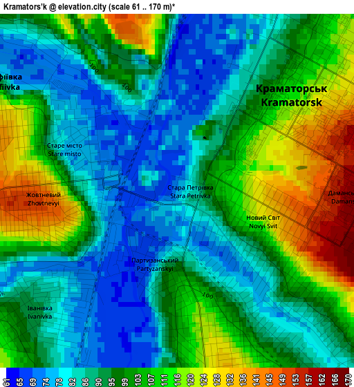
Below is the Elevation map of Kramators’k, which displays elevation range with different colors. Scale of the first map is from 61 to 170 m (200 to 558 ft) with average elevation of 97 meters (=318 ft) [note 1]
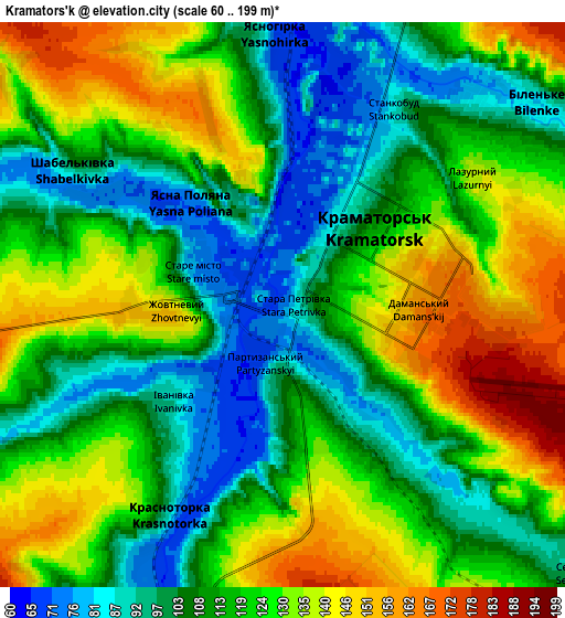
These maps also provides idea of topography and contour of this city, they are displayed at different zoom levels. More info about maps, scale and edge coordinates you can find below images.
| \ | Map #1 | Map #2 | Topo.Map |
| Scale [m] | 61..170 m | 60..199 m | × |
| Scale [ft] | 200..558 ft | 197..653 ft | × |
| Average | 97 m = 318 ft | 117.7 m = 386 ft | × |
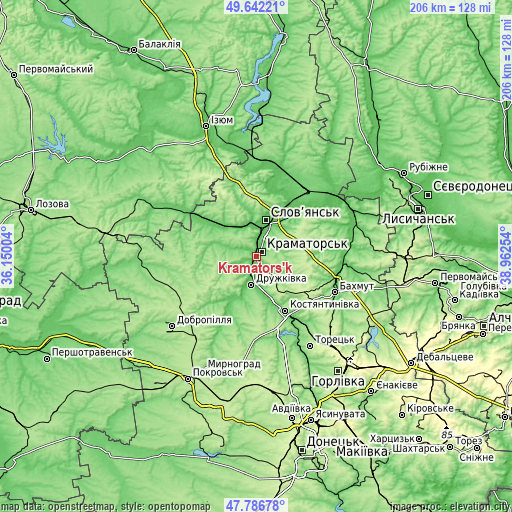
| Width | 6.45 km = 4 mi | 12.89 km = 8 mi | 206.3 km = 128.2 mi |
| Height | 6.45 km = 4 mi | 12.89 km = 8 mi | 206.3 km = 128.2 mi |
| ↑Max Latitude | 48.752032° | 48.780998° | 49.64221° |
| Latitude at center | 48.72305° | 48.72305° | 48.72305° |
| ↓Min Latitude | 48.694051° | 48.665035° | 47.78678° |
| ← Min Longitude | 37.512345° | 37.468399° | 36.15004° |
| Longitude center | 37.55629° | 37.55629° | 37.55629° |
| →Max Longitude | 37.600235° | 37.644181° | 38.96254° |
Nearby cities:
Cities around Kramators’k sort by population:
• Sloviansk elevation 61 m
16.6 km,  15°
15°
• Kostyantynivka 87 m
24.4 km,  152°
152°
• Bakhmut 102 m
35.5 km,  113°
113°
• Druzhkivka 101 m
10.3 km,  181°
181°
• Lyman 101 m
34.6 km,  31°
31°
• Chasiv Yar 230 m
26.4 km,  123°
123°
• Soledar 82 m
39.4 km,  97°
97°
• Svyatogorsk 66 m
34.5 km,  1°
1°
• Krasnotorka 72 m
4.9 km,  200°
200°
• Yampil’ 57 m
37.6 km,  51°
51°
• Drobysheve 100 m
37.6 km, 19°
• Kryva Luka 67 m
30.4 km,  56°
56°
Multilingual:
 En español:
Kramators’k elevación 74 m.
 En France:
Kramators’k élévation 74 m.
 Auf Deutsch:
Kramatorsk höhe über dem Meeresspiegel ist 74 m.

Sources and notes:
- [note 1] Map square and city borders are not equal. Map elevation data is calculated only from area inside that square.
- [src 1] Elevation data from geonames database provided with same terms of usage.
- [src 2] The elevation map of Kramators’k is generated using elevation data from NASA's 3 arcsec (90m) resolution SRTM data.
- [src 3] Base (background) map © OpenStreetMap contributors tiles are generated by Geofabrik and OpenTopoMap.
Copyright & License:
This Kramators’k Elevation Map is licensed under CC BY-SA. You may reuse any part from this page, if you give a proper credit by linking to this URL:
 More info on terms of use page.