Kryvyi Rih elevation
Kryvyi Rih (Dnipropetrovsk), Ukraine elevation is 99 meters and Kryvyi Rih elevation in feet is 325 ft above sea level [src 1]. Kryvyi Rih is a seat of a second-order administrative division (feature code) with elevation that is 58 meters (190 ft) smaller than average city elevation in Ukraine.
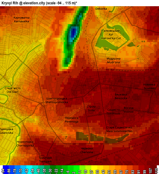
Below is the Elevation map of Kryvyi Rih, which displays elevation range with different colors. Scale of the first map is from -94 to 115 m (-308 to 377 ft) with average elevation of 72.9 meters (=239 ft) [note 1]
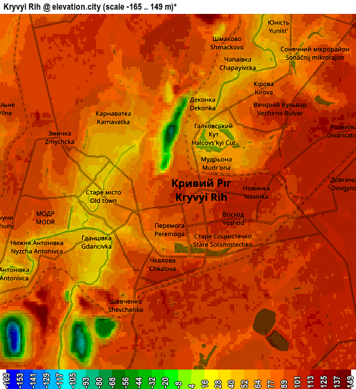
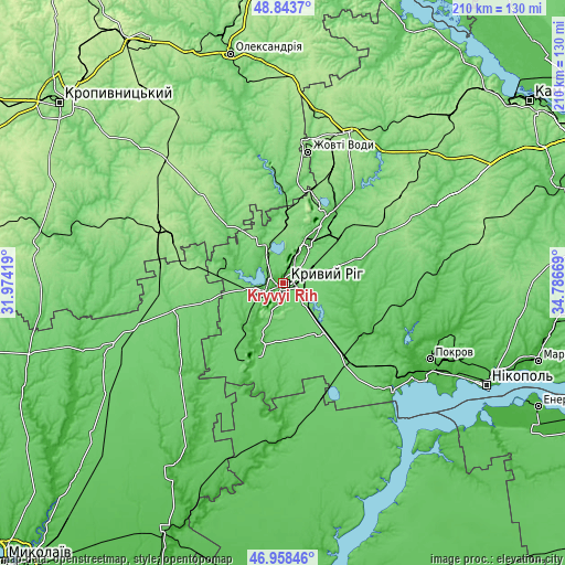
These maps also provides idea of topography and contour of this city, they are displayed at different zoom levels. More info about maps, scale and edge coordinates you can find below images.
| \ | Map #1 | Map #2 | Topo.Map |
| Scale [m] | -94..115 m | -165..149 m | × |
| Scale [ft] | -308..377 ft | -541..489 ft | × |
| Average | 72.9 m = 239 ft | 82.8 m = 272 ft | × |
| Width | 6.55 km = 4.1 mi | 13.1 km = 8.1 mi | 209.6 km = 130.2 mi |
| Height | 6.55 km = 4.1 mi | 13.1 km = 8.1 mi | 209.6 km = 130.2 mi |
| ↑Max Latitude | 47.939108° | 47.96854° | 48.8437° |
| Latitude at center | 47.90966° | 47.90966° | 47.90966° |
| ↓Min Latitude | 47.880195° | 47.850713° | 46.95846° |
| ← Min Longitude | 33.336495° | 33.292549° | 31.97419° |
| Longitude center | 33.38044° | 33.38044° | 33.38044° |
| →Max Longitude | 33.424385° | 33.468331° | 34.78669° |
Nearby cities:
Cities around Kryvyi Rih sort by population:
• Zhovti Vody elevation 151 m
49.3 km,  10°
10°
• Dolyns'ka 193 m
51 km,  295°
295°
• Apostolove 87 m
37.3 km,  138°
138°
• Shyroke 29 m
25.9 km,  200°
200°
• Petrove 104 m
47.1 km,  348°
348°
• Sofiyivka 108 m
40 km,  67°
67°
• Kazanka 92 m
42.3 km,  260°
260°
• Novovorontsovka 86 m
60.7 km, 138°
• Lozuvatka 88 m
17.8 km,  336°
336°
• Vysokopillya 86 m
47.8 km,  166°
166°
• Sholokhove 31 m
54.2 km,  116°
116°
• Ordzhonikidze 41 m
57.4 km, 117°
Multilingual:
 En español:
Kryvy Rig elevación 99 m.
 En France:
Kryvyï Rih élévation 99 m.
 Auf Deutsch:
Krywyj Rih höhe über dem Meeresspiegel ist 99 m.

Sources and notes:
- [note 1] Map square and city borders are not equal. Map elevation data is calculated only from area inside that square.
- [src 1] Elevation data from geonames database provided with same terms of usage.
- [src 2] The elevation map of Kryvyi Rih is generated using elevation data from NASA's 3 arcsec (90m) resolution SRTM data.
- [src 3] Base (background) map © OpenStreetMap contributors tiles are generated by Geofabrik and OpenTopoMap.
Copyright & License:
This Kryvyi Rih Elevation Map is licensed under CC BY-SA. You may reuse any part from this page, if you give a proper credit by linking to this URL:
 More info on terms of use page.